
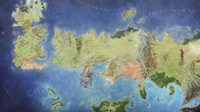
When the sixth season of Game of Thrones premieres on HBO this Sunday (April 24), one of the first thing fans will see is a camera panning across a map of Westeros, the fictional continent where the story begins. (Some may have already seen the opening credits sequence in 360-degree video.)
Starting with J. R. R. Tolkien’s hand-drawn maps in The Lord of the Rings novels, fantasy cartography—the art and science of mapping fictional worlds—has evolved into a genre of its own. Maps are the blueprints from which fantasy worlds are built, be they in games, books, or television shows prone to murdering their leading characters.
Defining the boundaries of a made-up universe takes a blend of imagination and practical knowledge of geography and physics, fantasy cartographers say. “As human beings, there’s only so much suspension of disbelief we can do,” said Robbie Powell, founder of the Cartographers’ Guild online community. “You have to have some level of reality . . . to allow the more fantastic aspect of things to thrive.”
One of the field’s best-known artists in the field is Jonathan Roberts. In 2012, the Scottish-born illustrator was tasked with creating the official maps of the world described in George R. R. Martin’s fantasy series A Song of Ice and Fire, on which Game of Thrones is based.
Quartz talked to Roberts about video games, rivers, what stresses him out about watching the show, and why he’s really, really qualified to talk about the physics of the natural world.
This interview has been condensed and edited.
Quartz: You live in New York. Where did you grow up?
Jonathan Roberts: I grew up in Scotland, just outside Edinburgh, in a house that is over 1,000 years old—because, Scotland. One thing that took me a little bit of time to get used to [in the US] is the lack of deep bones in the country. When you walk around, you don’t see half a medieval wall on the corner.
Where I grew up there was a castle down the hill. There was a Bronze Age fort behind the house. Nearby were limestone kilns from the 19th century and the palace where Mary Queen of Scots was born. It was just part of the fabric of the world that you existed in.
How did you get into mapping?
I am a gamer. That is the reason for the maps. I grew up playing Dungeons and Dragons. I ran a game at school that was a lot of fun, then moved to Poland after college and played Dungeons and Dragons over Skype to stay connected to friends back home. It’s a game of shared visualization, and it’s harder to share visualization when you’re not in the room together. You have to lay out what the world looks like so you can accurately describe it for all the people who have to believe it and know how to use it.
It’s the same reason any fantasy author has a map at the front of their books. It’s very useful to have some data visualization that gives people a point of reference for the world outside the text on the page. You need to believe there is a well-defined thing over the hill, even if the character never goes over that hill. You can’t make [decisions about a world] unless you come up with logic about the world, and for a fantasy world, you need that extra level of visualization to help.
I put the maps I made for my own games up on the internet. This led to commissions from small gaming companies. The commissions slowly got bigger. And then one day, the guys at Random House came to me and said George [R.R. Martin] loved my work and commissioned me to do The Lands of Ice and Fire [the collection of official maps published in 2012]. It was very much from hobbyist to pro illustrator, via putting fun stuff up on the internet and seeing if people liked it.
At what point in the writing of the Song of Ice and Fire series did you get involved?
When Random House approached me in 2012, the books had been in the world for a long time. [The first novel, A Game of Thrones, was published in 1996.] I first read them in college. There were these really clean, beautifully designed maps in the front of the novels.
But with the HBO show starting, there was an interest in having a properly finished world at scale, a canonized map of that world. At that point, Random House and George R.R. Martin decided they wanted a folio of poster maps. There are 12 maps. Each one is six square feet. The book covers the entire world for the first time. It was the first time the far east had ever been detailed, and the first map of the city of Braavos.
So that map in the opening credits of Game of Thrones—is that yours?
That is a beautiful piece of 3D animation work by an amazing Hollywood studio. That is in no way my map. I am not taking credit for that. That is a gorgeous piece of animation.
Is the show’s geography based on your maps?
My maps that I created for The Lands of Ice and Fire and HBO’s maps are completely different, particularly in the further east.
So is HBO wrong?
This is where it gets into an interesting discussion of cartography as fact. We live in a world where maps are a fixed static source of truth. In medieval times, that was not true. They were highly interpretive. They were more about how to get to a place, rather than exactly where that would be to the nearest mile.
My maps were intentionally created from the point of view of a maester of the Citadel in Westeros. The further east you go and the more distance you get from that location, the less detail there is on the map. There are whole kingdoms penciled in. Some areas will be labeled as lands of “men with wings.” It doesn’t mean there are literally men with wings there. It means there is a belief in Westeros that there are legends of men with wings there. So the fact that my maps and HBO’s maps disagree more and more the further east you go is a feature, not a bug.
That’s also the reason why there are no longitude or latitude lines on these maps in The Lands of Ice and Fire. That would imply a level of geospatial accuracy that is not fair to lay on these maps, given the time and technology with which they are supposed to be made. I originally included them, but George asked that those lines be removed. He said, “Don’t have them there. It’s going to make people believe these are more accurate than they should ever be interpreted as.”
Do you ever watch the show and notice inconsistencies in the landscape?
Yes. There are continuity errors for the world. I probably spot fewer than I should, but more than most.
[There was a scene of] Danaerys with her army, marching to capture another slave city. The army is marching along the coast, and as they march along the coast, the sea is to their right. And I was like, that is impossible. They are going the wrong way! They should be marching in the opposite direction. It irrationally infuriates me.
There’s a few of those. Not too many. To be fair, the HBO show has so clearly and explicitly divorced itself from the canon of the books in very particular ways that by definition there are going to be a bunch of things that are different by choice.
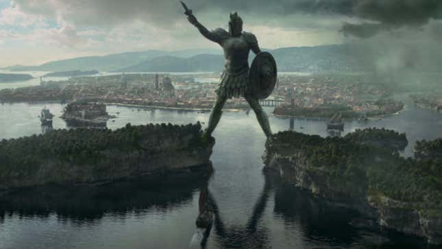
Then there are times like when they did their first establishing shot of the city of Braavos [at the end of season four]. I looked at it and saw the color palette and the rooftops and said, “That’s my map!” And that’s a wonderful feeling, to see that come to life and to know that what you saw in 2014 was the thing I spent days building in Photoshop in 2012.
What’s your relationship to the stories you illustrate? Do you ever feel like Martin’s characters are walking around in your universe?
The entire world is most definitely his. I just get to illustrate it.
It is fun to be able to dive deeper into that world than most other people get to. When you start laying out a geography on paper for the first time, you end up asking questions that most authors haven’t been asked. When we read these pages, we get to see a tiny fragment of the world the authors have in their heads. But when you illustrate, you’re stepping off that page and opening up the rest of the world. You’re asking, What kind of forest is this over here? What kind of trees? What kind of foliage? What color is the sea that you have in your mind for this section of ocean?
Sometimes you find that there’s an awful lot of intention and thought and background and lore that went into it. Those are the kinds of questions you have to answer to draw the map properly, but authors don’t get asked often. As soon as you ask, you get very clear answers very quickly.
What are your main principles of mapping fictional worlds?
The number of times I get map sketches [from authors] with rivers running uphill is incredibly frequent, or rivers that split when they go to an ocean. There are maybe one or two cases in the world where that actually exists, but it’s incredibly rare. A desert that runs up against a swamp is not feasible most of the time. Scattered mountains don’t really make sense. They generally follow tectonic plates rubbing up against each other.
There are a lot of exceptions to those rules, but if you make [the map] a little bit more normal, it just means there’s no uncanny valley effect, that sense of, “This is about right, but it’s not right.” That level of doubt causes people to doubt a fantasy world, and that’s exactly what you want to avoid. If you answer people’s first questions easily, then selling them on dragons and magic is much easier. The geography shouldn’t be the thing that makes people go “That’s weird” about a fantasy world.
Then when there is something weird, call that out. Get really obvious when there is something unusual or exceptional. If there is an enormous rift in the center of this continent caused by an ancient magical war, it better be bloody obvious and clear that this thing is not natural. If we have to suspend our disbelief about magic, we shouldn’t have to suspend our disbelief about geography, geology, and physics.
So is this your day job?
I used to be, for many years, a theoretical particle physicist. I have a PhD in theoretical particle physics, and spent a lot of time studying dark matter and cosmic rays from other galaxies. I was a postdoctoral researcher at NYU when I did the maps for The Lands of Ice and Fire. I left physics about three years ago, and now work in digital media. I run data science and audience development for About.com.
I’ve given two talks at Google. One was about theoretical physics, the other was about mapping Game of Thrones. They only put the Game of Thrones video up on YouTube.
Do you know how the series ends, and if so, could you please tell us?
I do not know how the series ends. I do know a little bit more than most about the next book. I was sent a set of chapters from The Winds of Winter [the forthcoming sixth book in the series] in 2012, with geographic details about the city of Braavos which were specifically required to be in the maps to support the plot of the upcoming novel. I do not know what those plot points are, just that they are important.
I have no idea whether Jon Snow is alive or dead. I only have the same guesses as everyone else on the entire internet.