On Nov. 7, California’s governor-elect Gavin Newsom issued a State of Emergency, as three major wildfires—the Camp, Woolsey, and Hill fires—continue to burn across the state.
On Nov. 7, California’s governor-elect Gavin Newsom issued a State of Emergency, as three major wildfires—the Camp, Woolsey, and Hill fires—continue to burn across the state.
The Camp Fire—named such because it started in Camp Creek Road, not necessarily because it started on a campground—swept through the town of Paradise, California, north of San Francisco, overnight. The Woolsey fire in Thousand Oaks (you may have heard the name this week as it was the scene of a mass shooting), just north of Los Angeles, has pushed more than 75,000 residents from their homes. The fire burned down homes and jumped highway 101, triggering the . Meanwhile, the Hill fire is also raging nearby, splitting Los Angeles area fire crews between the two. Residents have as the flames have burned a path from the Santa Rosa Valley to the Pacific Ocean.
Join 500,000+ readers who start their day with Quartz.
By subscribing, you agree to our Terms of Service and Privacy Policy.
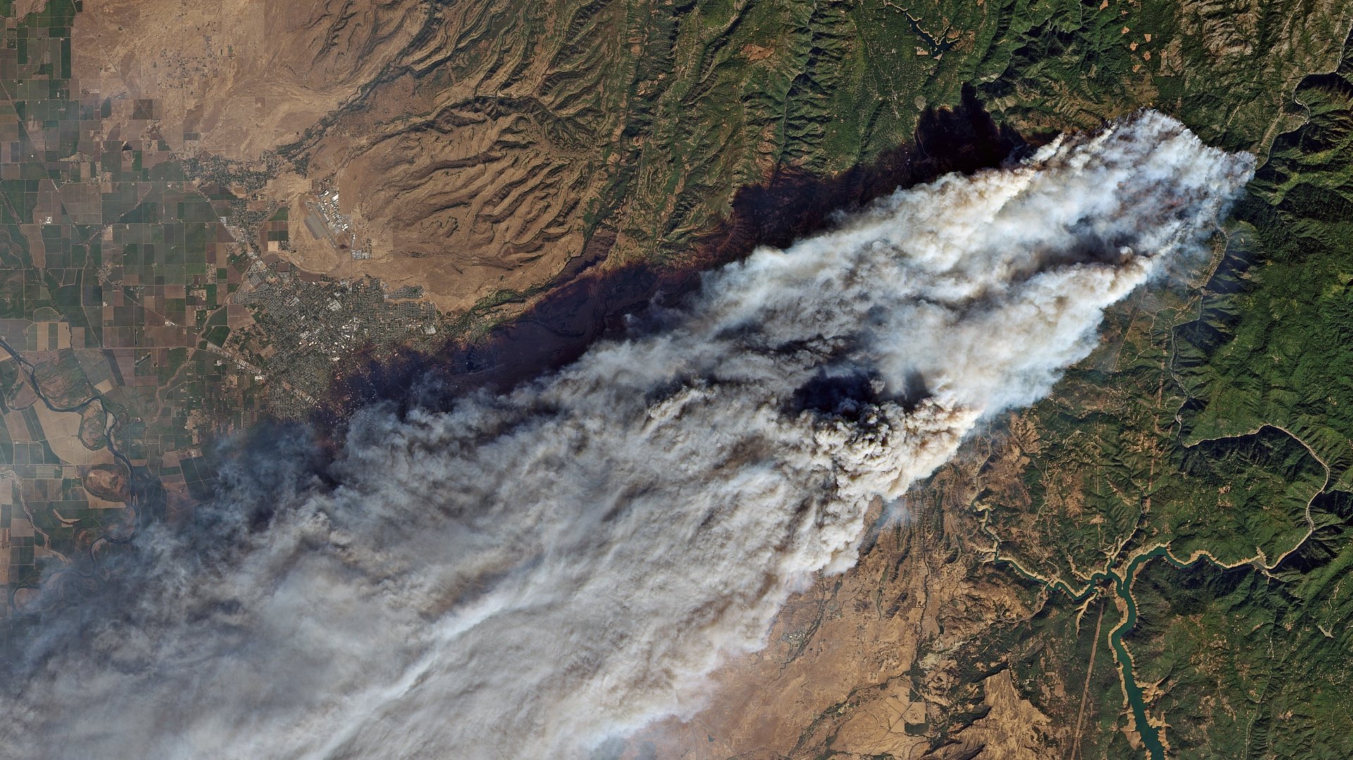
Schools across the San Francisco Bay and Los Angeles areas have closed as air quality indexes reach unhealthy levels. Nov. 9 satellite imagery of the state show the Pacific coast blanketed by wildfire smoke.
So far, the Camp Fire has proved to be the most deadly. On Nov. 8, the fire overtook the town of Paradise, California overnight. In the aftermath, the Butte County sheriff’s office reported that they had recovered five bodies from burned vehicles. “Pretty much the community of Paradise is destroyed,” Cal Fire Captain Scott McLean told reporters, according to the Associated Press. Strong winds and dry conditions fed the flames that expanded at a rate of 185 square miles (480 sq. km) every minute. The town is home to more than 26,000 people. Evacuation orders are in effect for five nearby towns, as the fire burns over 70,000 acres (283 sq. km) and is only 5% contained.
Pierre Markuse, a satellite imagery analyst, took a look at the satellite images of the Camp Fire. Combining the satellite’s visual spectrum bands and short-wave infrared emissions as indicators of heat helps experts understand what areas are actively burning, even when smoke obscures the flames from above. “This way hot spots are highlighted and usually align quite well with active fires. Although the image looks like [it’s] showing flames, those are actually zones of stronger infrared emissions,” Markuse told Quartz.
Imaging techniques like these enable first responders to understand the scope and spread of wildfires overtime. The National Weather Service (NWS) uses the NASA- and NOAA-operated satellite GOES-16 (Geostationary Operational Environmental Satellite-R Series) to track fire temperatures and forecast where the fires are at risk of spreading. The satellite, which was launched in 2016, relays information at one-minute intervals, offering experts up-to-date information. Now, whenever there’s a fire, NWS can communicate with first responders on the ground. Knowing the path of the fires helps them limit the spread by clear cutting, dropping fire retardant, or issuing evacuations—critical for emergency responders in a state where fires burn for more of the year, and kill more often.
While forecasting techniques improve, emergency response systems are still lacking. During the deadly fires that blazed in Sonoma and Napa in Oct. 2017, victims were apparently not adequately alerted, according to a report. So in response, on Sept. 21 this year, the California state senate passed bill 833 that requires the government to develop emergency alert guidelines across counties and cellphone service providers by July 1, 2019.
Until then, it is up to fire departments and county governments to fight fires. For now, they’re still in the thick of it—the Los Angeles County fire Chief Deputy expects up to 90,000 residents to evacuate by the end of Friday night, while the Camp Fire looms over Chico where another 90,000 residents may need to take flight. We’ll only be able to assess how well the state was able to respond once the smoke clears.