When Russia’s leading mapping service attempted to blur out each and every military facility in Israel and Turkey, it inadvertently revealed their exact locations, perimeters, and potential functions to “anyone curious enough to find them all,” according to Matt Korda of the Nuclear Information Project at the Federation of American Scientists, the researcher who discovered the error.
When Russia’s leading mapping service attempted to blur out each and every military facility in Israel and Turkey, it inadvertently revealed their exact locations, perimeters, and potential functions to “anyone curious enough to find them all,” according to Matt Korda of the Nuclear Information Project at the Federation of American Scientists, the researcher who discovered the error.
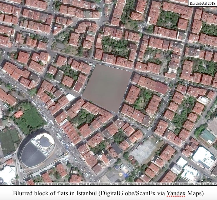
The obscured sites on Yandex Maps’ web-based mapping service range from airfields and munitions-storage bunkers to what Korda described as “small, nondescript buildings within city blocks.” The laborious task of blurring each location was almost certainly done at the behest of both Israel and Turkey, not of the company’s own volition, Korda said on the FAS Strategic Security blog. No locations in Russia, including nuclear facilities, submarine bases, air bases, and launch sites, were obscured in any way.
Join 500,000+ readers who start their day with Quartz.
By subscribing, you agree to our Terms of Service and Privacy Policy.
“Mapping services like Yandex typically play a reactive role in these cases, as they are responding to requests from outside sources to obscure a pre-defined list of sites,” Korda told Quartz. “Since no Russian sites have been blurred, I would assume that the Russian Ministry of Defense hasn’t asked Yandex to do so.”
A Yandex spokesperson confirmed this was indeed the case.
“Our mapping product in Israel conforms to the national public map published by the government of Israel as it pertains to the blurring of military assets and locations,” the spokesperson told Quartz in an email. “Our Turkish map product observes local rules and regulations similarly.”
Korda said his interest was initially piqued after hearing rumors that Yandex was selectively blurring out certain sites around the world, but he didn’t have anything more specific to go on. After doing a manual search that identified Israel and Turkey as the two nations whose satellite imagery Yandex had altered, Korda then spent a couple of weeks going through the maps of both countries section by section, dropping pins in Google $GOOGL Earth on the spots that were obscured.
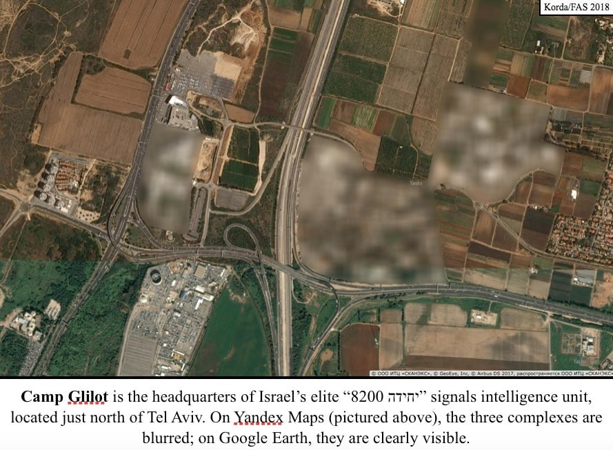
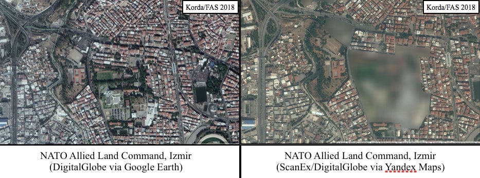
So far, he’s pinned over 300 distinct sites in Israel and Turkey, from airfields and ports to bunkers, storage sites, bases, barracks, nuclear facilities, and random buildings. At least two NATO facilities in Turkey have been blurred by Yandex, including Incirlik Air Base, where approximately 50 American B61 nuclear bombs are housed, according to the US Congressional Research Service.
Selectively obscuring satellite imagery was “certainly an effective censorship method before such images became freely available, and was institutionalized by practice, if not by law, in several countries,” said Korda. “However, now that pretty much anyone with an internet connection can access high-resolution satellite imagery for free on a variety of platforms, obscuring aerial imagery no longer makes sense and can actually backfire, as seen in the Yandex case.”
Earlier this year, military analysts realized that data-visualization maps posted online by Strava, a fitness tracking company, had accidentally exposed the exact locations of secret US facilities across the globe.
“While these types of incidents are a boon to OSINT [open-source intelligence] analysts, I would hope that these incidents prompt governments to recognize that their data is becoming increasingly accessible through open-source methods,” Korda said. “Correspondingly, they should take the relevant steps to secure information that is absolutely critical to national security, and be much more publicly transparent with information that is not—hopefully doing away with needless censorship in the process.”
This article has been updated with comment from Yandex.