This year, the avatar for great Japanese design is not a robot, a car, or a chair, but a map…made of paper. The AuthaGraph World Map, a proportionally accurate projection that finally represents earth’s neglected continents, was bestowed the grand prize at Japan’s Good Design Awards last month.

This year, the avatar for great Japanese design is not a robot, a car, or a chair, but a map…made of paper. The AuthaGraph World Map, a proportionally accurate projection that finally represents earth’s neglected continents, was bestowed the grand prize at Japan’s Good Design Awards last month.
Designed by architect Hajime Narukawa and graduate students from Keio University, the map, which can also be folded into an accurate paper globe, bested more than 43,000 entries in the annual nationwide contest. The judges lauded Narukawa’s map for providing ”an advanced precise perspective of our planet,” praising its faithful representation of all oceans and continents, including the neglected continent of Antarctica.
Join 500,000+ readers who start their day with Quartz.
By subscribing, you agree to our Terms of Service and Privacy Policy.
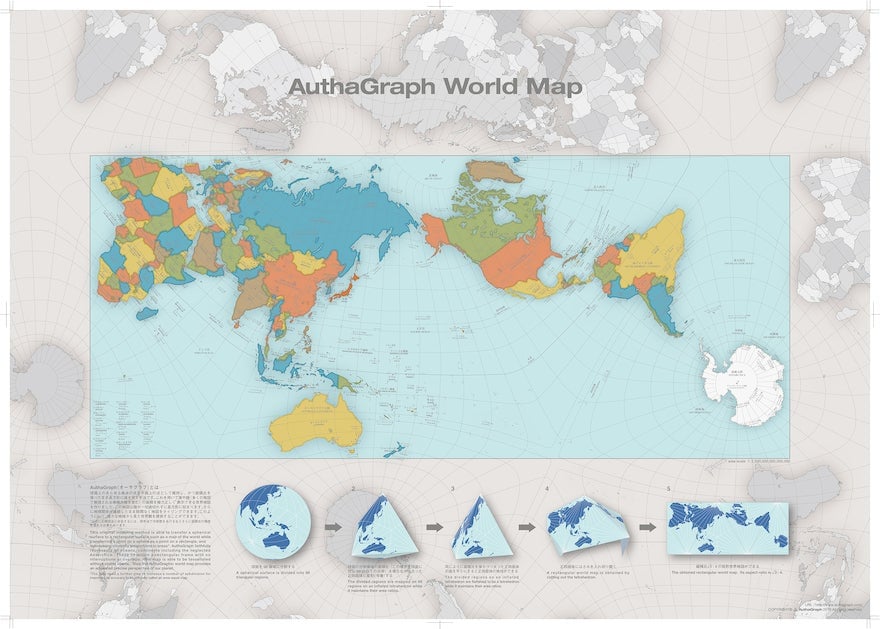
The AuthaGraph World Map also improves upon map projections that distort the true proportions of nations, often as a form of Western propaganda. In the 447-year old Mercator projection, for instance—widely used in classrooms and Google $GOOGL Maps—Antarctica looks like the biggest land mass on the planet, when in reality it’s larger than only Europe and Australia.
“The AuthaGraphic world map aims to provide a new viewpoint to perceive the world by equally showing these interests spread over the globe,” Narukawa explains on his website.
The Good Design panel did note an improvement that Narukawa and his students can work on—increasing the number of subdivisions to make it a truly “area-equal” map.
Narukawa, a 45-year-old architect who studied the tenets of Buckminster Fuller’s geodesic dome and the optical illusions of M.C. Escher, runs a design firm in Tokyo specializing in the everyday applications of geometry. After experimenting with several area-mapping techniques, he found that by dividing a sphere in 96 equal triangles one could produce an accurate flat map that can be folded in any shape while retaining cartographic accuracy.