From a Himalayan lake whose DNA results deepened its own mystery to a Siberian blast that still defies full explanation, these are 20 real places science hasn't fully cracked
Credit: Canva Images
Satellites can resolve objects the size of a dinner table from orbit. A full human genome can be sequenced for less than the cost of a used car. Yet a specific, mapped, physically visitable set of locations on Earth continues to produce data that scientists have not been able to reconcile into one settled explanation.
These are not campfire stories. Every place on this list has been examined by credentialed researchers: geologists, archaeologists, biologists, physicists. They have published papers and proposed competing models. In some cases, they have formally rebutted each other's conclusions in peer-reviewed journals. What separates these locations from folklore is exactly that level of scrutiny. The more carefully several of them get studied, the more open questions turn up. A 2019 genetic study of skeletons pulled from a Himalayan lake was expected to confirm a single group of ninth-century pilgrims. It instead found three unrelated populations from different centuries and different continents, leaving researchers with a new puzzle in place of an old one. A 2023 paper on circular bare patches in the Namibian desert was written specifically to rebut a 2022 paper on the same patches. The two camps have not reconciled.
None of this means science has failed. It means researchers are being precise about the difference between a working theory and settled proof. A few places on this list have one leading explanation that most specialists accept, with only technical details still contested. Others have two or more serious competing theories and no resolution in sight. Several are places where one part of the puzzle got solved decades ago, like why a waterfall runs red. A related question, like what triggers it to flow at all, is still being worked out with new instruments.
What follows is a tour of 20 such places, chosen because each is real, has coordinates, and carries documented scientific uncertainty rather than invented mystery. Some are well known. Others rarely leave academic journals. Together, they are a reminder that mapping a place completely and understanding it completely are two different achievements.
Credit: Atypeek Dgn / Pexels
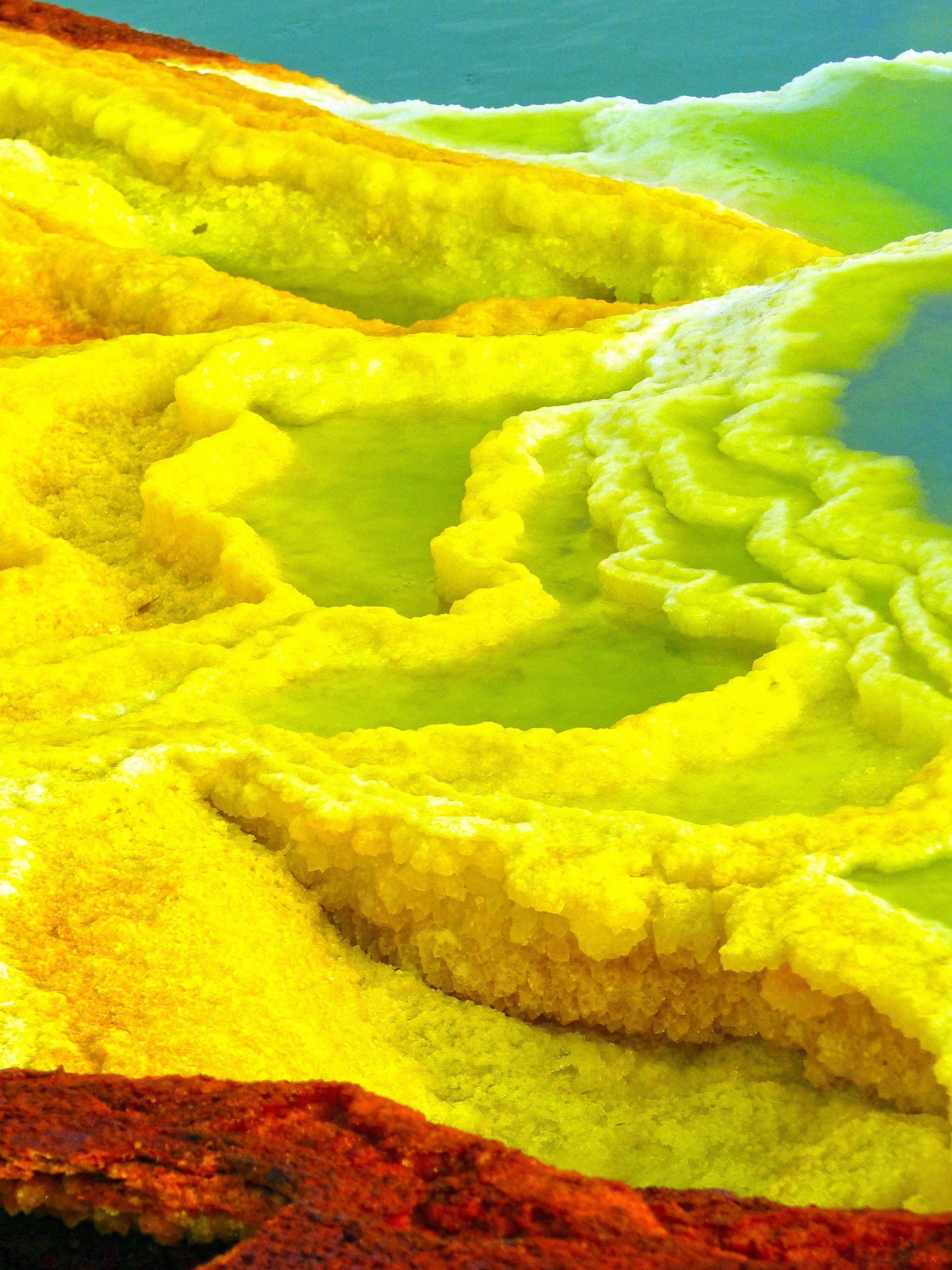
The Danakil Depression sits in Ethiopia's Afar region, at the point where the Nubian, Somali and Arabian tectonic plates meet and slowly pull apart. The plates are separating at about seven millimeters a year, a pace that will eventually flood the region with ocean water and create a new sea. For now, the depression is one of the lowest, hottest and driest places on the planet, with much of its floor sitting 100 to 150 meters below sea level.
At the northern end of the depression lies Dallol, a hydrothermal field formed by a phreatic eruption in 1926, when rising magma heated underground water into steam. Dallol's hot springs reach a pH near zero and temperatures as high as 109 degrees Celsius, ranking among the most chemically extreme environments known on the surface of the planet. Yellow sulfur deposits, iron oxide reds and copper-tinted greens color the pools, and birds that land to drink from them are sometimes found dead at the edges.
For more than a decade, researchers have debated one specific question: whether anything lives in the most extreme pools at Dallol. Field teams have detected microbes in the nearby Lake Assale salt flats without much difficulty. But in the hottest, most acidic and most saline ponds, including the Black Lake and Gaet'ale pond, repeated searches have failed to confirm life. One study reported archaea living in these extreme brines, but later research challenged that finding. The chemistry there, a mix of high acidity, high salinity and specific chaotropic salts, may cross a genuine threshold that cells cannot survive.
That unresolved question is exactly why astrobiologists keep returning. Dallol has become a reference site for studying where the physical and chemical limits of life actually sit. That information shapes what instruments future missions carry when they search for life on Mars or Saturn's moon Titan. The Danakil region carries other scientific weight, too: in 1974, researchers recovered a 3.2 million-year-old fossil later named Lucy, an Australopithecus afarensis skeleton, from nearby deposits. It is now displayed in Addis Ababa. This ground produced one of the most important fossils in the story of human origins. It is also the ground where scientists still cannot agree on where life's chemistry finally gives out.
Credit: Brandon Morrison / Pexels
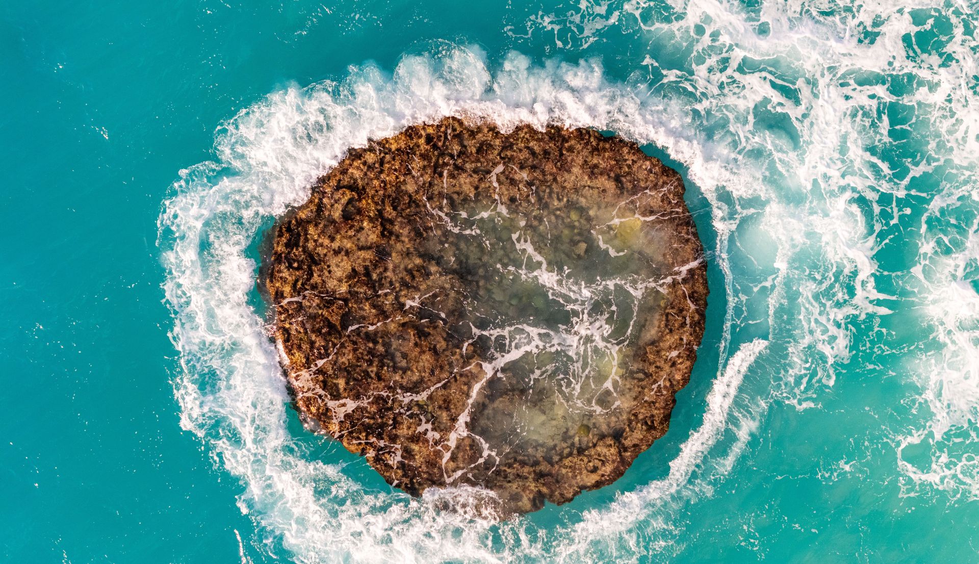
The Bermuda Triangle is not a fixed legal boundary. It is a loosely defined stretch of the north Atlantic Ocean bounded roughly by Miami, Bermuda and Puerto Rico. The area gained its reputation after decades of reported ship and aircraft disappearances. Oceanographers and aviation researchers have looked closely at the pattern. Their consensus is that the region does not experience a higher rate of loss than other similarly busy stretches of ocean. Heavy shipping traffic, sudden storms, strong currents and human error account for most of the incidents linked to the area.
That statistical conclusion does not mean every individual case has been explained. The disappearance of the USS Cyclops in 1918 remains one of the largest unexplained losses in U.S. Navy history, and it is still formally unresolved. The Cyclops was a 542-foot Navy collier carrying more than 300 crew members and roughly 11,000 tons of manganese ore from Brazil toward Baltimore. It never sent a distress signal despite having the equipment to do so, and no wreckage has ever been recovered despite extensive searches. President Woodrow Wilson is remembered as saying at the time that only fate and the sea knew what had become of the ship. Two of the Cyclops's sister vessels later vanished under similar circumstances on nearby routes in 1941, again without a trace.
Flight 19 is the other case that investigators never fully closed. On December 5, 1945, five Navy TBM Avenger bombers left Fort Lauderdale, Florida, on a routine training run. The flight leader became disoriented, compass problems compounded the error, and the planes ran out of fuel somewhere over open water. A rescue seaplane sent out that same night to search for them also disappeared, and none of the wreckage from either incident was ever located.
None of this requires a supernatural explanation. Deep, fast-changing water, mechanical failures decades before modern tracking technology, and ordinary human mistakes plausibly explain both losses. What keeps the Cyclops and Flight 19 in circulation among historians rather than closed case files is simpler. The specific chain of events that sank a full Navy ship and downed six aircraft has never been confirmed, and the wreckage that could confirm it has never surfaced.
Credit: Patel Parth / Pexels
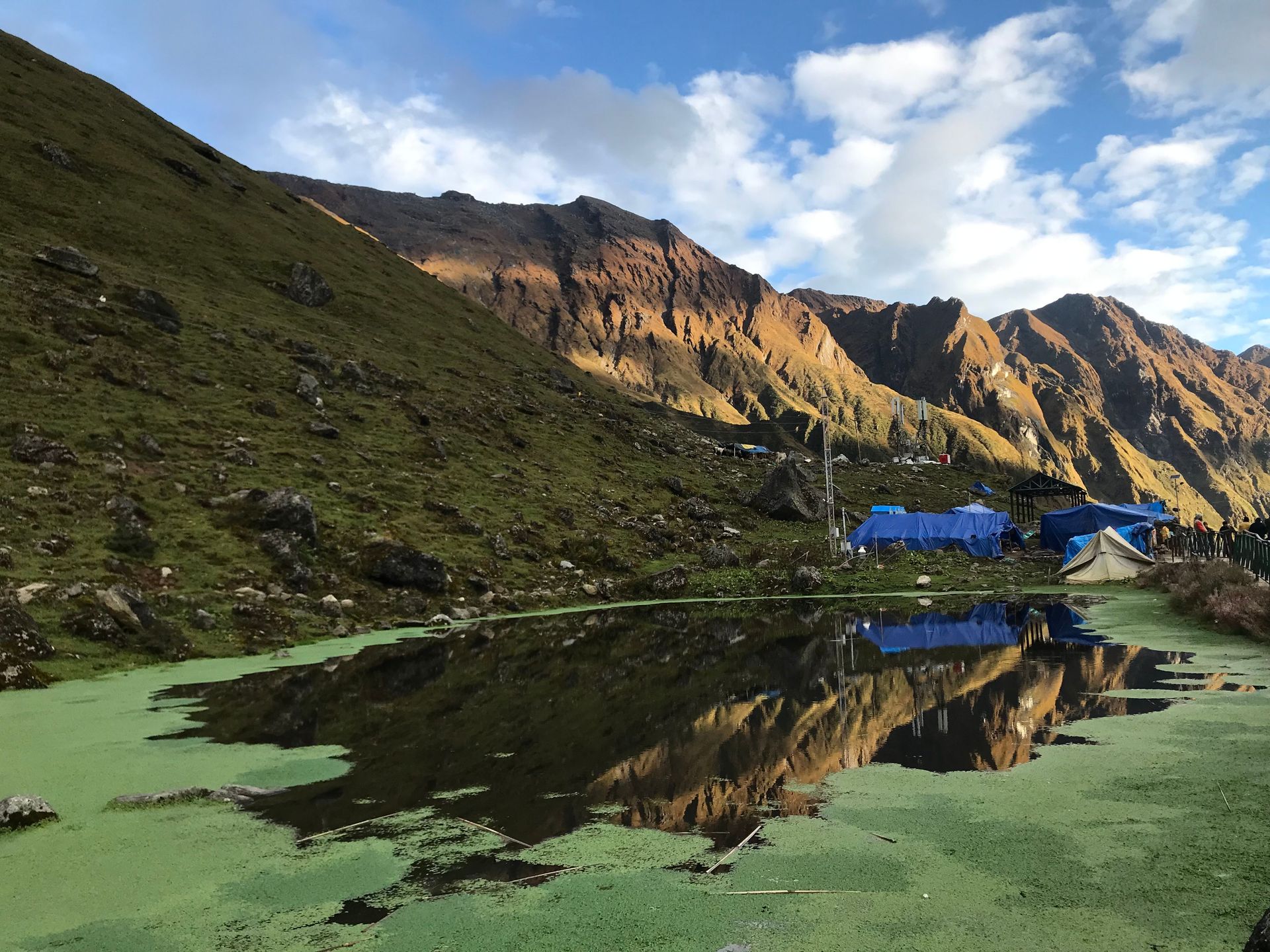
Roopkund Lake sits more than 5,000 meters up in the Indian Himalayas, in the Chamoli district of Uttarakhand, hemmed in by the peaks of Trishul and Nanda Ghunti. The lake itself is small, rarely more than 40 meters across, and frozen for most of the year. Its shores and shallows hold the skeletal remains of several hundred people, first reported by a forest official in 1942 and known locally for generations before that as Skeleton Lake.
Early forensic work found unhealed fractures on many of the skulls, and radiocarbon dates clustered around 800 CE. Those findings led researchers to a tidy explanation: a single group of ninth-century pilgrims caught in a sudden, severe hailstorm, struck down by ice rather than weapons. For years, that was the accepted account.
In 2019, a team of 28 researchers led by Éadaoin Harney published a genome-wide ancient DNA analysis of 38 of the skeletons in the journal Nature Communications. The geneticist David Reich served as senior author. The results did not confirm the pilgrimage story. They fractured it. The skeletons split into three genetically distinct groups with no relationship to one another. Of these, 23 individuals had ancestry consistent with present-day South Asian populations. They died in one or more events clustered around the eighth to tenth centuries, matching the old radiocarbon dates. But 14 more individuals carried ancestry closely related to people living today in Crete and mainland Greece. Radiocarbon dating placed their deaths around 1800 CE, roughly 1,000 years after the first group. A single additional skeleton showed Southeast Asian ancestry from around that same later period.
No historical record explains why a group of people with eastern Mediterranean ancestry would have traveled to a remote lake in the Himalayas and died there in the 19th century. The research team floated a few possibilities, including an undocumented European expedition that may have hired Mediterranean guides or soldiers. They acknowledged that no known expedition matches the evidence, and that a Mediterranean pilgrimage to a Hindu holy site seems an unlikely fit. Roopkund is now a rarer kind of scientific mystery: one that a rigorous, well-funded, peer-reviewed study made more complicated rather than less.
Credit: Canva Images
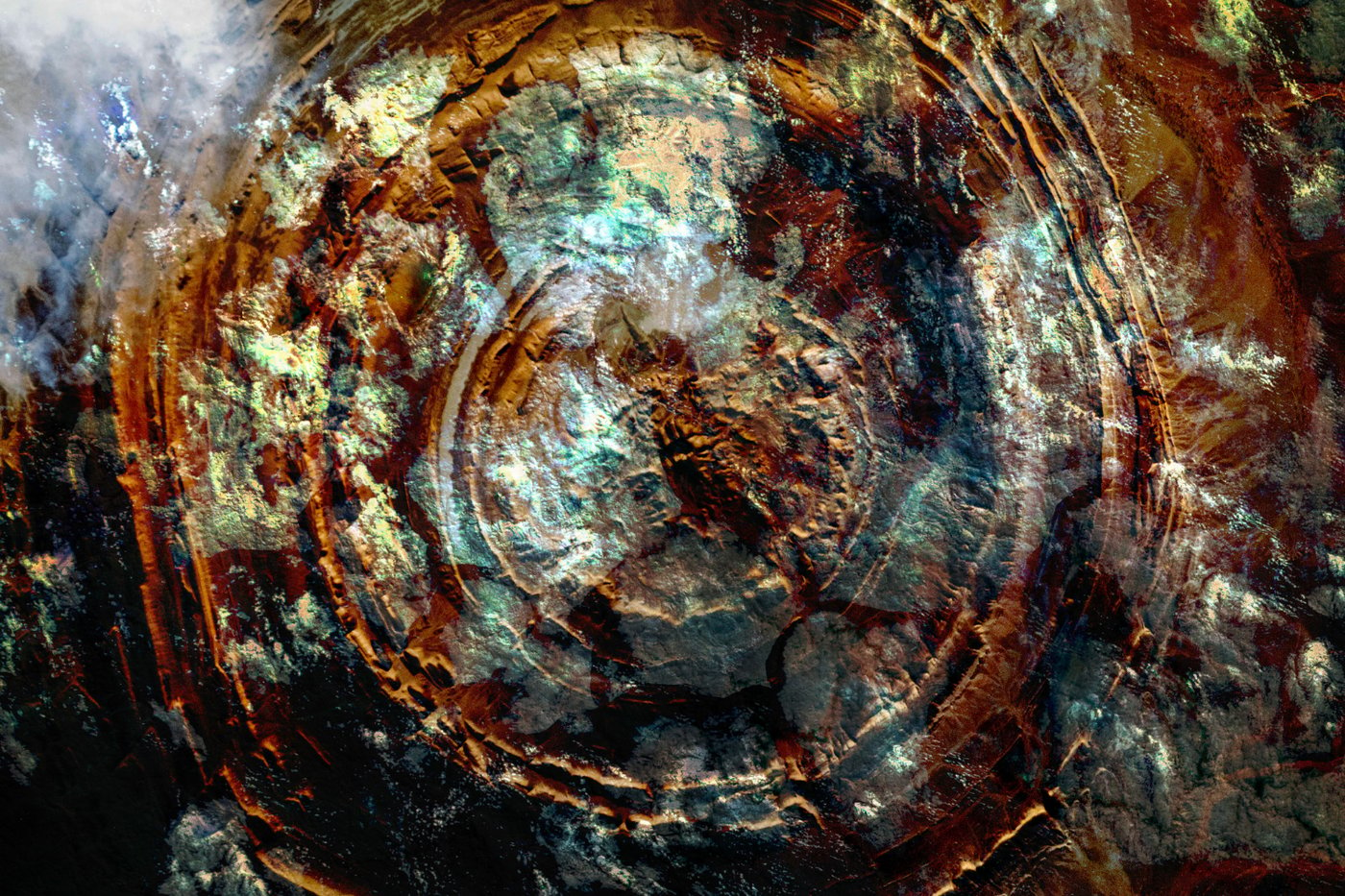
From low orbit, a nearly perfect set of concentric rings rises out of the Sahara Desert in northwestern Mauritania, roughly 40 kilometers across. It is visible enough that astronauts have used it as a navigation landmark. Known as the Richat Structure, or locally as Guelb er Richât, it sat unexplained for decades after French researchers first mapped it in the late 1930s and 1940s.
The earliest serious theory held that the Richat Structure was an impact crater, gouged out by an asteroid or comet. That idea has since been ruled out. Impact craters typically leave a shattered, brecciated zone of rock and often a raised central peak formed as bedrock rebounds after the strike. Melted rock from the heat of impact is often present too. The Richat Structure shows none of these signatures. Once eroded material is mapped in satellite images, a different shape emerges: a domed anticline. That is a broad, symmetrical bulge of sedimentary rock, layered up to 600 million years old, pushed upward from below. Wind and water have since worn it down into a bullseye of exposed rock rings.
That answers what the structure is not. It does not fully answer what pushed it upward in the first place. Beneath the sedimentary bulge sits a complex of igneous rock, dated to the Cretaceous period around 100 million years ago. It includes gabbro, carbonatites, kimberlite intrusions and other volcanic material arranged in overlapping ring shapes. A 2014 study in the Journal of African Earth Sciences examined this igneous core in detail. It concluded that, despite decades of prior research, two things remained unclear: how these individual rock types relate to one another, and what sequence of magmatic events produced them. In the researchers' own words, understanding of both remained very poor.
In other words, geologists have closed the case on whether the Richat Structure fell from space. They have not closed the case on the precise volcanic history that built it from underneath, one ring at a time. That process played out roughly 100 million years before anyone would be alive to see it from orbit.
Credit: jpatokal / Wikimedia Commons (CC BY-SA 3.0)
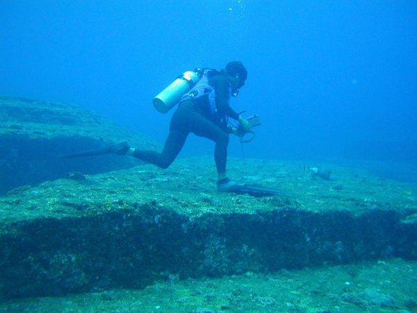
In 1986, a diver named Kihachiro Aratake was scouting a site to watch hammerhead sharks off Yonaguni Island, the westernmost inhabited island in Japan's Ryukyu chain. There, he came across a large, angular rock formation on the seafloor. Submerged between five and 25 meters down, the formation includes stepped terraces, straight edges and right-angled corners cut into sandstone and mudstone, spanning roughly 50 meters in length.
Masaaki Kimura, a marine geologist at the University of the Ryukyus, has spent decades arguing that the formation is at least partly man-made. In his view, it is a stepped structure, possibly a ceremonial platform, carved when the area stood above water more than 10,000 years ago, before rising seas submerged it. He points to what he interprets as carved steps, drainage-like channels and markings resembling script.
Robert Schoch, a geologist at Boston University who dove the site in 1997, represents the opposing camp, which includes most geologists who have examined the formation. Schoch has argued that Yonaguni's sandstone splits naturally along parallel bedding planes. The region's frequent earthquakes, he says, fracture that sandstone into the kind of sharp, rectangular blocks visible at the site. Similar angular formations, he notes, occur elsewhere with no artificial explanation required. A 2024 study of the site's sediment and rock structure reported finding no tool marks or other direct archaeological evidence of human construction.
The disagreement has not fully closed, in part because the two sides are answering slightly different questions. Kimura's case rests on interpreting specific features as intentional. Schoch's case rests on the ordinary behavior of fractured sandstone. Most publishing geologists side with the natural explanation. Kimura, though, remains a credentialed, publishing scientist rather than a fringe figure. Neither side has produced the kind of decisive physical evidence, a tool mark under a microscope, a dateable construction layer, that would end the argument outright. Yonaguni remains what it has been since 1986: a real rock formation whose interpretation depends on which geologist is asked.
Credit: Stephan Getzin / Wikimedia Commons (CC BY 2.5)
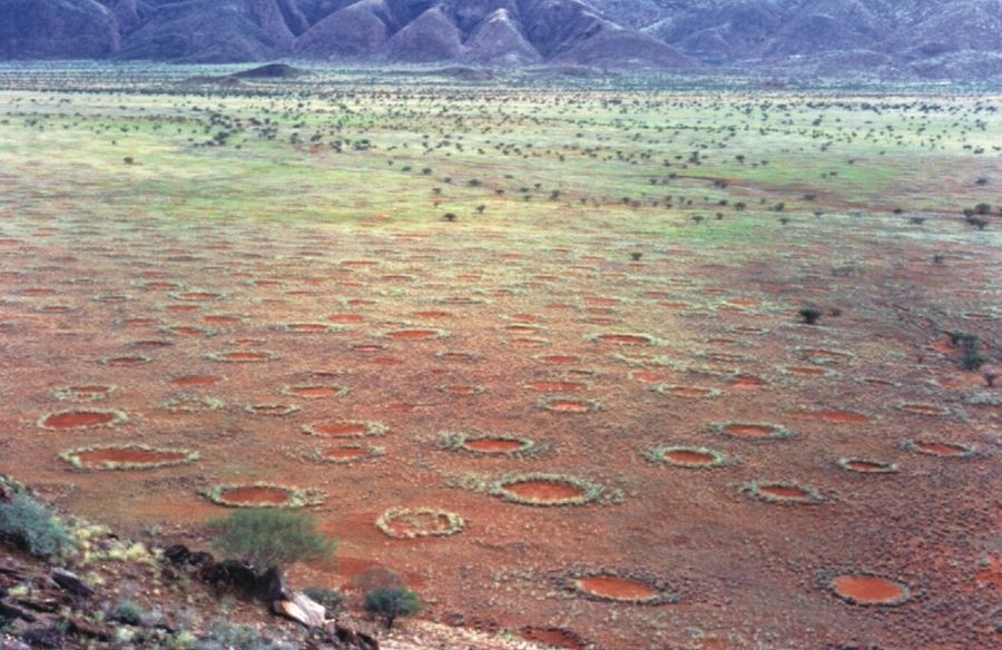
Across huge stretches of grassland on the edge of the Namib Desert, bare circular patches of soil appear in a pattern so regular it looks almost engineered. The patches space apart in a loose honeycomb that stretches for miles. Similar circles have since been documented in Angola, South Africa and, farther afield, in the Pilbara region of Western Australia. For nearly 50 years, two rival explanations have competed for the title of correct answer, and the competition has not ended quietly.
The first explanation points to sand termites. Termite colonies, in this view, clear vegetation directly above their nests. The resulting bare patch lets rain soak deep into the soil instead of evaporating. That creates an underground water reserve that sustains the colony through dry spells. The second explanation removes insects from the story entirely. Under this self-organization model, grasses simply compete for scarce water. Plants at the rim of a bare patch draw down the soil moisture so effectively that nothing can establish itself in the center. The circle persists as a stable, self-reinforcing pattern with no builder required.
In 2022, researchers from the University of Göttingen published soil-moisture data suggesting that grasses inside the circles died immediately after rainfall, independent of termite activity. They took as support for the self-organization model. Termite researchers did not accept this. In 2023, a rebuttal from the University of Hamburg reported sand termites present at more than 1,700 individual circles across three countries. Argued that the Göttingen team had misread its own soil-moisture measurements by sampling only the topsoil rather than deeper layers where a termite-built reservoir would actually hold water.
Neither side has backed down. A separate 2023 paper in the Proceedings of the National Academy of Sciences proposed that a plant trait called phenotypic plasticity might help reconcile the two camps. 2024 research on the Australian circles suggested they may form through an entirely different. Non-biological weathering process. Fairy circles in different countries might not even share one single cause. Half a century after the pattern was first described, professional soil scientists are still publishing direct responses to one another's data.
Credit: Wikimedia Commons / PICRYL
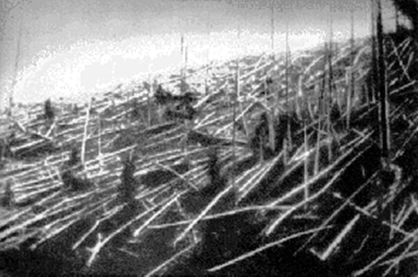
At around 7:14 in the morning on June 30, 1908, a massive explosion tore through the sky over the Podkamennaya Tunguska River in central Siberia. Witnesses reported a fireball crossing the sky, a shockwave that knocked people off their feet many kilometers away, and a sound heard up to 800 kilometers distant. The blast flattened roughly 2,000 square kilometers of forest, an area larger than greater London. An estimated 80 million trees were snapped or uprooted in a radial pattern pointing away from a single center.
No crater was ever found. Because the region was so remote, the first scientific expedition did not reach the site until 1927, nearly two decades later, led by Soviet mineralogist Leonid Kulik. By then, any fragments of whatever caused the explosion had long since been scattered by weather, wildlife and time. All that turned up were tiny magnetite and silicate globules, not the kind of debris field a large meteorite impact typically leaves behind.
The leading explanations have long split between two candidates. One holds that the object was an icy comet, or a fragment of one, that vaporized violently in the atmosphere. Would explain both the missing crater and the unusually bright night skies reported afterward across Europe as comet dust scattered sunlight. The other holds that it was a stony or metallic asteroid, roughly 50 to 100 meters across, that detonated in an airburst before reaching the ground. Current opinion, including NASA's, leans toward the asteroid explanation, though the case is not closed. A 2020 modeling study from Siberian Federal University proposed a third option: an iron asteroid that grazed Earth's atmosphere at a shallow angle, exploded. Continued back out into space rather than falling to the ground, which would account for the total absence of recovered fragments.
More than a century of investigation has narrowed the possibilities without eliminating the argument. Some researchers still contend that neither the comet nor the asteroid model accounts cleanly for every piece of physical evidence recorded that morning. Tunguska as a rare case where the explosion is thoroughly documented and the thing that caused it is not.
Credit: brc sngn / Pexels
For most of the 20th century, archaeologists worked from a fairly settled sequence: humans domesticated crops, then settled into villages. Only after that did they have the surplus labor and organization to build monuments and temples. Gobekli Tepe, a hilltop site in southeastern Turkey near the city of Şanlıurfa, breaks that sequence apart.
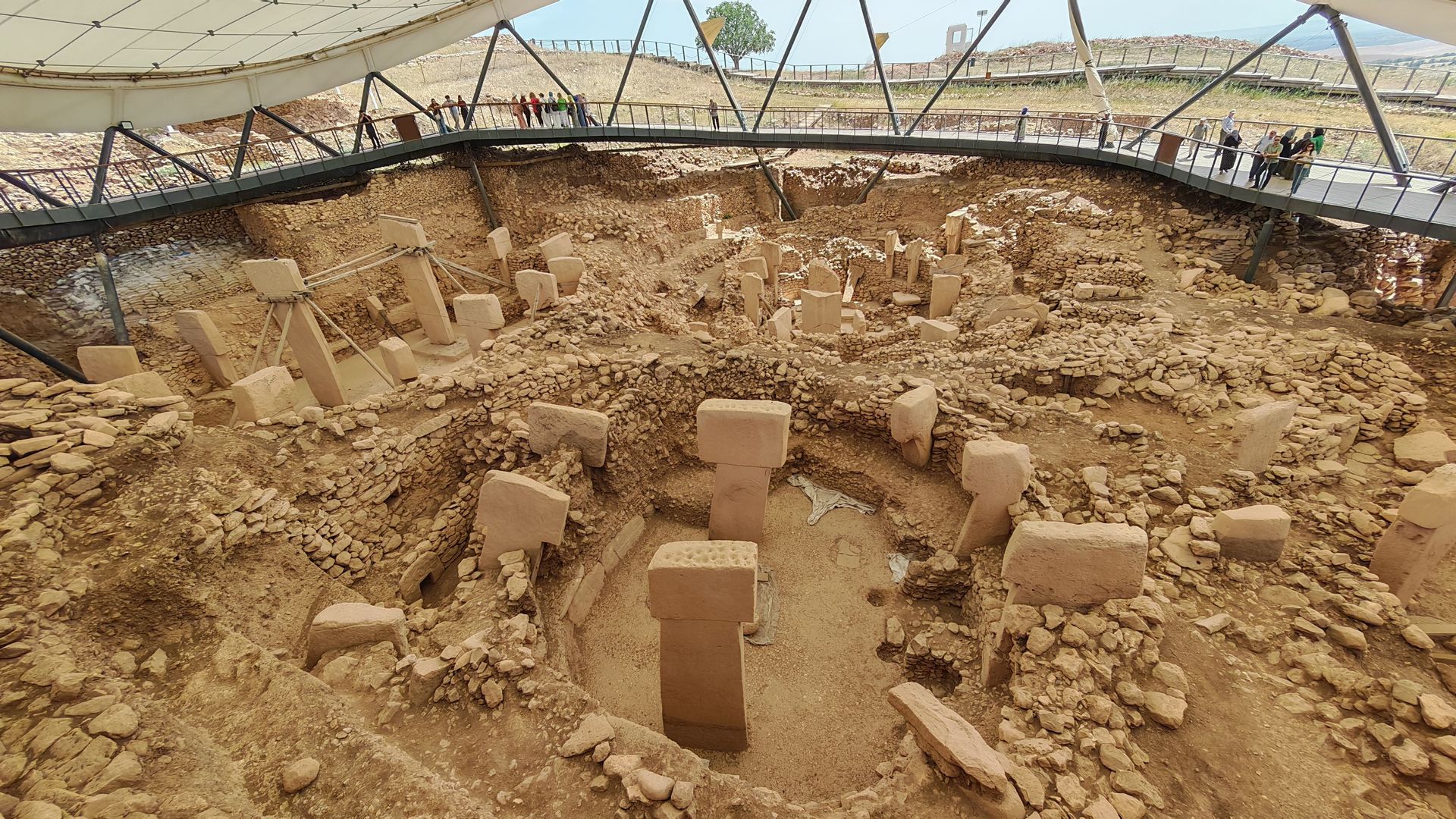
Radiocarbon dating puts the oldest construction at the site at roughly 11,500 years old, placing it firmly in the pre-pottery Neolithic period. Thousands of years before the first confirmed evidence of farming or permanent villages anywhere in the region. It predates Stonehenge by around seven millennia. Yet Gobekli Tepe is not a scattering of huts. It includes at least 20 circular or oval enclosures built from massive T-shaped limestone pillars. Some weighing several tons and standing up to six meters tall, many carved with images of foxes, boars, vultures, snakes and other wild animals. Excavation began in earnest in 1994 under the German archaeologist Klaus Schmidt, after the site had been dismissed decades earlier as an unremarkable medieval cemetery.
The puzzle is not just the date. It is the logistics. Quarrying, shaping, transporting and raising multi-ton stone pillars requires coordinated labor, planning and a reliable food supply. Hunter-gatherer societies were not supposed to have those things without agriculture first. A 2020 study in the Cambridge Archaeological Journal used computer modeling to analyze the layout of the three earliest enclosures. It found their placement followed a single geometric plan based on an equilateral triangle. Evidence that the complex was conceived and laid out as one coordinated project rather than added to piecemeal over generations by unrelated groups.
Researchers still debate how large and how settled the community building Gobekli Tepe actually was, with some recent excavation suggesting longer-term habitation than the original hunter-gatherer model assumed. What is not in dispute is that people without domesticated animals, wheels, metal tools or a farming surplus organized themselves to build something monumental. They did it thousands of years before anyone thought that was possible. Archaeologists are still working out exactly how they managed it.
Credit: Quang Nguyen Vinh / Pexels
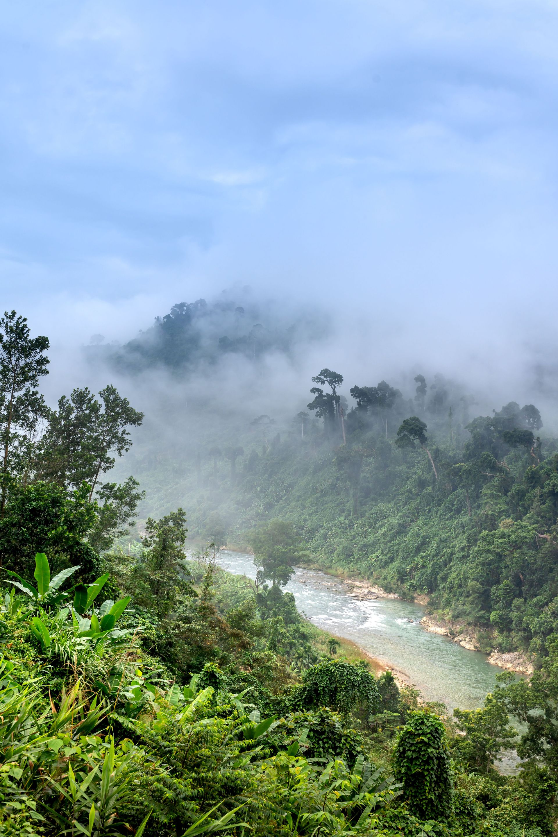
Deep in the Peruvian Amazon $AMZN, near a site called Mayantuyacu, a river known locally as Shanay-Timpishka runs warm at its headwaters and reaches temperatures close to boiling farther downstream. Hot enough to cause fatal burns to any animal unlucky enough to fall in. Local communities have described the river for generations, attributing its heat to Yacumama, a serpent spirit said to birth both hot and cold waters. For a long time, outside scientists assumed the stories described something more ordinary, like a heated stream near a hot spring, and largely left it uninvestigated.
Andrés Ruzo, a Peruvian geoscientist, first went looking for the river as a doctoral student at Southern Methodist University, after hearing about it for years from his grandfather. Colleagues in the oil and geothermal industries told him such a river could not exist that far from a volcano. The nearest active volcanic center sits more than 700 kilometers away, and boiling rivers elsewhere in the world are reliably tied to nearby magma. Ruzo visited anyway, guided by a family connection to a local shaman who protected the site, and confirmed the river was real. At its hottest points, he has personally recorded temperatures above 99 degrees Celsius.
The explanation Ruzo and other geologists have settled on does not require a volcano. Rainfall seeps deep into the ground along fault lines in the surrounding sedimentary basin. The Earth's ordinary geothermal gradient, the same gradual heating with depth found everywhere on the planet, warms the water. Under pressure, that heated water rises rapidly back up along the same faults, arriving at the surface still hot rather than losing its heat gradually along the way.
What remains unusual is the scale. Non-volcanic hydrothermal systems exist elsewhere. Ruzo, who has surveyed geothermal systems on multiple continents, says he has not found another non-volcanic river that produces heat at anything close to this magnitude. The general mechanism is understood. Why it reaches this extreme in this one stretch of rainforest. Not in any comparable sedimentary basin elsewhere on Earth, is still an open question in a field with very few other examples to compare it against.

Credit: Sergey Guk / Pexels
Traveling through the Malay Archipelago in the 1850s, the British naturalist Alfred Russel Wallace, who developed the theory of natural selection independently of Charles Darwin, noticed something odd. Islands that sat close enough to see from one another held wildlife from entirely different worlds. West of a line running through the narrow strait between Bali and Lombok, and on north between Borneo and Sulawesi, animals were recognizably Asian: elephants, tigers, monkeys. East of that line, the fauna shifted toward marsupials, cockatoos and other species with Australian roots. The boundary was later named the Wallace Line, after Wallace, by the biologist Thomas Henry Huxley.
Much of the explanation is now well established. During past ice ages, falling sea levels exposed enough of the continental shelf to link many of the islands on the Asian side into a single landmass geologists call Sunda. To link New Guinea and Australia into a landmass called Sahul. But the strait between Bali and Lombok remained deep even at the lowest sea levels of the last ice age. Keeping a narrow, permanent water barrier in place while land bridges formed around it. Species can cross narrow water gaps occasionally, but a deep strait acts as a much stronger filter than a wide one.
Some of the finer details are still being revised. A 2023 study proposed that an ancient collision between the Australian and Asian tectonic plates, tens of millions of years ago. Triggered climate shifts that explain why Asian species crossed east into the transition zone known as Wallacea more successfully than Australian species crossed west. Producing the lopsided pattern still visible in the region's wildlife today. A separate, competing boundary drawn farther east, called Lydekker's Line, marks where Sahul species stop, leaving the intervening islands as a mixed zone rather than a clean line. Newer research has even reopened the question of whether a temporary land bridge briefly connected Bali and Lombok during past ice ages. Would complicate the strait-based explanation that has anchored the Wallace Line for more than a century.
More than 160 years after Wallace first drew it, the line he mapped by observation alone is still being redrawn by data.
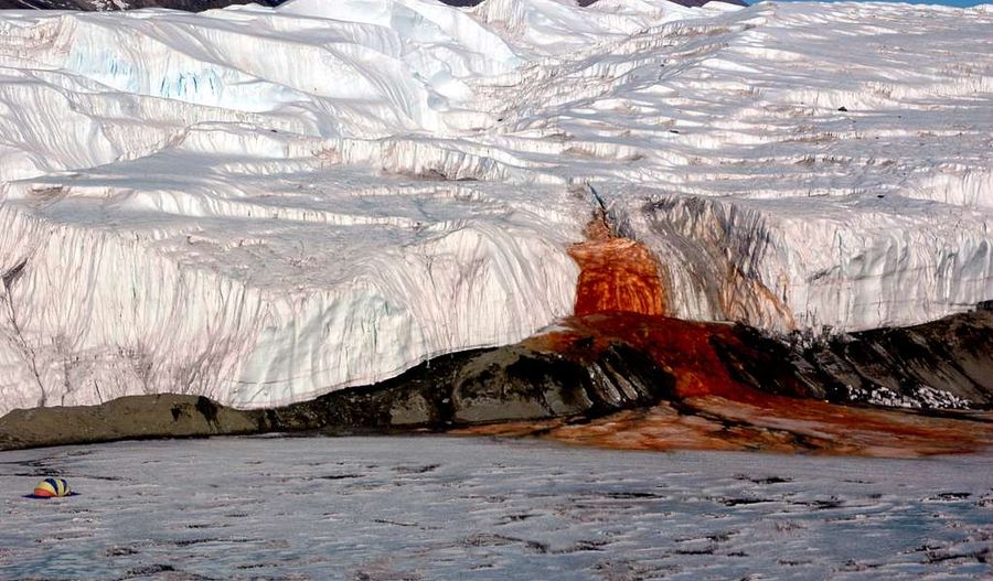
Photo: Peter Rejcek / National Science Foundation / Wikimedia Commons / Get Archive
At the edge of Taylor Glacier, in the McMurdo Dry Valleys of Antarctica, a deep red liquid seeps out of the ice and stains the surrounding snow. The Australian geologist Thomas Griffith Taylor documented it in 1911 and initially guessed the color came from red algae. The real explanation took most of a century to work out in full.
The red comes from iron. A body of hypersaline water sits trapped beneath the glacier. Sealed off for more than a million years since an ancient pocket of seawater was cut off from the ocean as ice built up over it. That brine has spent all of that time picking up dissolved iron from the surrounding bedrock, in complete darkness, without oxygen. When the iron-rich brine finally reaches open air through cracks in the glacier, it oxidizes on contact, the same chemical reaction that turns exposed iron to rust. The water runs red.
Why the brine flows as a liquid at all, rather than freezing solid, puzzled researchers for years. The salt content is high enough to lower the water's freezing point substantially. The slow release of heat as any of the water does freeze helps keep the rest of it liquid, aided by pressure from the glacier above. In 2017, a team from the University of Alaska Fairbanks used radar to trace the actual plumbing. A roughly 300-meter network of channels connecting the buried brine source to the falls, mapped for the first time.
Inside that sealed brine, researchers have also found an active community of bacteria that has never been exposed to sunlight or oxygen. Surviving instead on sulfur and iron chemistry, an ecosystem that has operated in total isolation for over a million years. The mechanics of the system are still being filled in, too. A study published this year in the journal Antarctic Science described a rare, direct observation from September 2018, when a GPS station. A daily camera and underwater temperature sensors happened to be running at the same time and captured an actual discharge event. The glacier's surface dropped by about 15 millimeters, its forward movement slowed by nearly 10 percent. Fresh red staining spread across Blood Falls within days. It was the first real-time look at what triggers the bleeding, more than a century after Taylor first saw it.
Credit: stein egil liland / Pexels
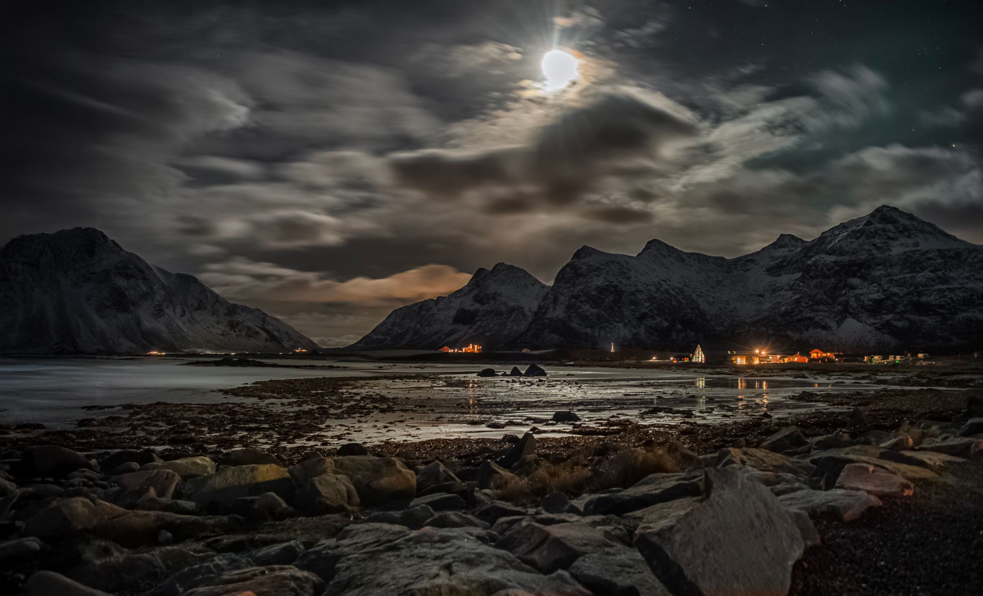
In a quiet 12-kilometer stretch of valley near the town of Røros in central Norway, unexplained lights have been reported since at least the 1930s. Locals call the area Hessdalen. Between 1981 and 1985, sightings surged sharply, with residents reporting as many as 20 separate appearances of the lights in a single week, drawing national and eventually international attention.
The lights themselves defy a single simple description. Witnesses report white, yellow or red glowing shapes that appear by day or by night, sometimes hovering in place for over an hour. Sometimes moving quickly across the valley, occasionally tracked on radar as well as camera. That variability is part of why the phenomenon has resisted a tidy explanation: any theory has to account for lights that behave differently from one sighting to the next.
Unlike most reported light phenomena, Hessdalen has been studied with real instruments for four decades. Erling Strand launched Project Hessdalen in the early 1980s, working with Norway's Østfold University College. Italian physicists later joined the effort through a collaboration known as the EMBLA project, run with Italy's National Research Council. In 1998, researchers installed an automated monitoring station in the valley, nicknamed the Blue Box. It ran optical cameras, radio receivers, a magnetometer and radar continuously, rather than relying on witness accounts alone.
That instrumentation has ruled out some individual sightings, including cases later traced to aircraft, car headlights, mirages and ordinary astronomical objects. It has also turned up genuine correlations between the light events and local magnetic disturbances and radio emissions, correlations that any full explanation will eventually need to account for. One hypothesis, tied to the valley's history of small-scale mining, proposes that dust containing minerals such as scandium reacts with atmospheric gases under specific conditions, producing a slow, glowing combustion. Norwegian media once reported that this theory had solved the mystery outright. It had not. More than 40 years after Project Hessdalen began recording data, researchers studying the valley still describe the phenomenon as lacking a single, agreed cause.
Credit: Oliodisemini / Wikimedia Commons (CC BY-SA 4.0)
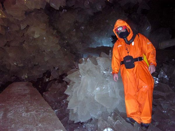
Beneath the Naica mountain in Chihuahua, Mexico, an active lead, silver and zinc mine cuts through a chamber that miners uncovered by accident. A cave lined with selenite crystals larger than almost any found elsewhere on the planet, some running longer than 10 meters. Reaching the cave means descending into conditions that are close to unlivable, with air temperatures between 45 and 65 degrees Celsius and humidity near 99 percent. Researchers who visit wear cooling suits and can typically work for only about 20 minutes before retreating.
In 2008 and 2009, the astrobiologist Penelope Boston, then affiliated with New Mexico Tech, collected fluid trapped inside tiny pockets within the crystals themselves. Sealed off from the outside world as the crystals grew, over what researchers estimate could be as long as 500,000 years. In 2017, speaking at the annual meeting of the American Association for the Advancement of Science, Boston announced that her team had revived dormant bacteria and archaea from that fluid. Organisms she described as genetically distinct enough from anything else known that their nearest relatives were roughly as different as humans are from mushrooms. Based on the estimated growth rate of the surrounding crystal, the team calculated the microbes could have been dormant somewhere between 10,000 and 50,000 years. Surviving in the dark by metabolizing iron, sulfur and manganese rather than relying on sunlight.
Not every scientist accepted the finding as presented. Purificación López-García, a researcher at the French National Centre for Scientific Research, raised a specific concern. She had worked on an earlier, separate study of microbial life in the cave's warmer spring water. That microorganisms could have been introduced during the drilling process itself, riding in on equipment or living in tiny surface fractures. Mistaken for organisms genuinely sealed inside ancient fluid. She said she remained skeptical pending stronger evidence. Other microbiologists found the claim plausible, pointing to precedent from ice-core studies where organisms far older have reportedly been revived. The research had not completed peer review at the time Boston announced it.
Years later, the core disagreement has not been settled in public view: whether Naica's crystals sealed genuine ancient life inside them, or whether modern contamination has been mistaken for it.
-1920x1280.jpg)
Credit: Fernando Flores / Wikimedia Commons (CC BY-SA 2.0)
Where the Catatumbo River empties into Lake Maracaibo, in Venezuela's Zulia state, the sky produces more lightning per square kilometer than anywhere else measured on Earth. In 2014, Guinness World Records certified the location after satellite data from NASA's Tropical Rainfall Measuring Mission recorded an average of 233 lightning flashes per square kilometer each year. A figure well ahead of any other location studied.
The storms are frequent enough that sailors have relied on them for centuries. Ships approaching Maracaibo at night could spot the near-constant flashes from far offshore and use them to navigate, earning the phenomenon the nickname Maracaibo's lighthouse. A poem written in 1597 credits the lightning with exposing an attempted nighttime raid by the English privateer Francis Drake two years earlier. It lit up his ships before they could approach undetected. According to the U.S. National Oceanic and Atmospheric Administration, storms form over the area on roughly 140 to 160 nights a year, frequently lasting nine or 10 hours at a stretch.
The basic mechanics are reasonably well understood. Warm, humid air rising off the lake collides at night with cooler air draining down from the Andes. The Sierra de Perijá mountains ring the basin on three sides. That collision, concentrated by the surrounding topography right where the Catatumbo River enters the lake, produces the ideal conditions for repeated thunderstorm formation.
What that general explanation does not fully account for is the sheer scale of the effect at this one specific location. Similar mountain-and-lake wind patterns exist elsewhere in the world without producing anything close to Catatumbo's flash rate. Researchers have not yet produced a model that explains, in full quantitative terms, why this convergence of geography produces a lightning hotspot. No comparable terrain anywhere else comes close. The general cause understood while the exact reason for its extremity remains a live question in atmospheric science.
Credit: Victor Rodriguez / Pexels
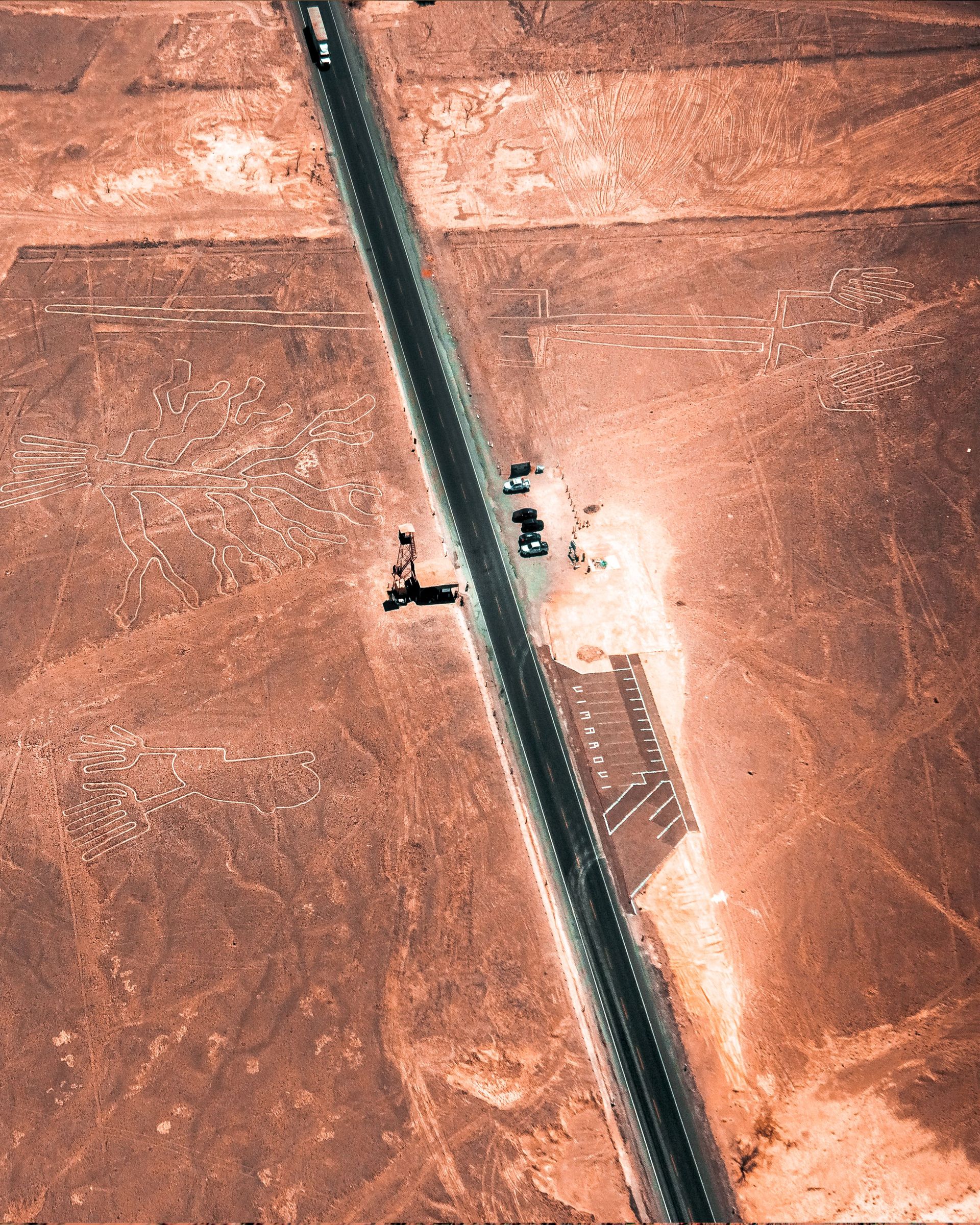
Carved into the desert plain of southern Peru, roughly 400 kilometers south of Lima, the Nazca Lines include nearly 1,200 individual geoglyphs. About 800 straight lines, some stretching close to 30 miles, along with roughly 300 geometric shapes and about 70 large depictions of animals, plants and human figures. The Nazca culture created most of them between around 500 BCE and 500 CE. The extreme dryness of the region, among the most arid on Earth, is the main reason they have survived at all.
Peruvian archaeologist Toribio Mejía Xesspe first documented the lines on foot in 1926, but their true scale only became clear once commercial aviation over the region increased in the 1930s. American researcher Paul Kosok noticed in 1941 that some lines aligned with the winter solstice. The German-born mathematician Maria Reiche spent roughly 40 years afterward building a detailed case that the lines functioned as a kind of astronomical calendar.
Later archaeologists have pushed back on that framing without fully rejecting it. Given how little rain the Nazca region receives, several researchers, including Johan Reinhard, have argued the lines more likely served a ritual purpose tied to water and fertility. Possibly created as offerings or as part of ceremonies invoking rain from the surrounding mountains. The archaeologist Michael Coe has proposed that some lines functioned as processional pathways, walked as part of religious ceremonies rather than viewed from above. Other researchers argue the purpose likely shifted over time, starting as ritual walkways for pilgrims and later incorporating practices such as smashing pottery at line intersections.
New sections continue to surface. Drone and satellite surveys in recent years have identified dozens of previously unknown figures in the surrounding hills, expanding the known catalog and complicating any single, tidy theory of purpose. Mainstream archaeology has firmly rejected fringe claims that the lines required outside help to construct, since wooden stakes, rope and simple sightlines are sufficient to explain the geometry. But the deeper question, why a civilization without writing devoted this much labor to drawings only fully visible from the air, remains open across multiple credible, competing academic explanations.
,_август_2012-1920x1440.jpg)
Credit: Rakot13 / Wikimedia Commons (CC BY-SA 3.0)
Starting in 1970, Soviet scientists on Russia's Kola Peninsula, near the Norwegian border, began drilling straight down for reasons that had nothing to do with oil or mining. The Kola Superdeep Borehole was a pure research project, an attempt to reach as deep into the continental crust as engineering would allow. By 1989, the main branch of the hole had reached a true vertical depth of 12,262 meters, or about 7.6 miles, through a shaft only 23 centimeters wide. It remains the deepest artificial point ever reached on Earth, deeper than the Mariana Trench. It penetrated only about a third of the way through the 35-kilometer-thick crust at that location and never reached the mantle the project had hoped to sample.
Almost everything the drill encountered contradicted the era's geological models. Scientists expected a transition into basalt rock at around seven kilometers down, based on how seismic waves behaved at that depth. It never appeared. Granite continued instead, and the seismic signal turned out to reflect a change within the granite itself rather than a shift to a new rock type. Between three and six kilometers down, the crew found free water moving through cracks in the rock, something the standard models of the time held should be impossible. Pressure at that depth was assumed to compress rock too tightly for water to persist. Around six kilometers, researchers recovered microscopic plankton fossils roughly two billion years old, encased in rock that had never been touched by any prior drilling.
The drilling mud also came up saturated with hydrogen gas, likely produced by a process called serpentinization. In that reaction, heated water reacts with iron- and magnesium-rich minerals deep in the crust. That observation, filed away for decades, has drawn fresh attention as energy companies explore naturally occurring hydrogen as a clean fuel source. Heat proved to be the project's limit. Temperature at the bottom reached 180 degrees Celsius by 1992, roughly double what models predicted, turning the deep rock plastic rather than solid and making further drilling impractical. The oldest rock recovered, granite from the Precambrian era, dated to about 2.7 billion years old. The hole was capped and abandoned in the 1990s, but the models it broke are still being rebuilt.
Credit: Diego Padilla Durán y Mariordo / Wikimedia Commons (CC BY-SA 4.0)
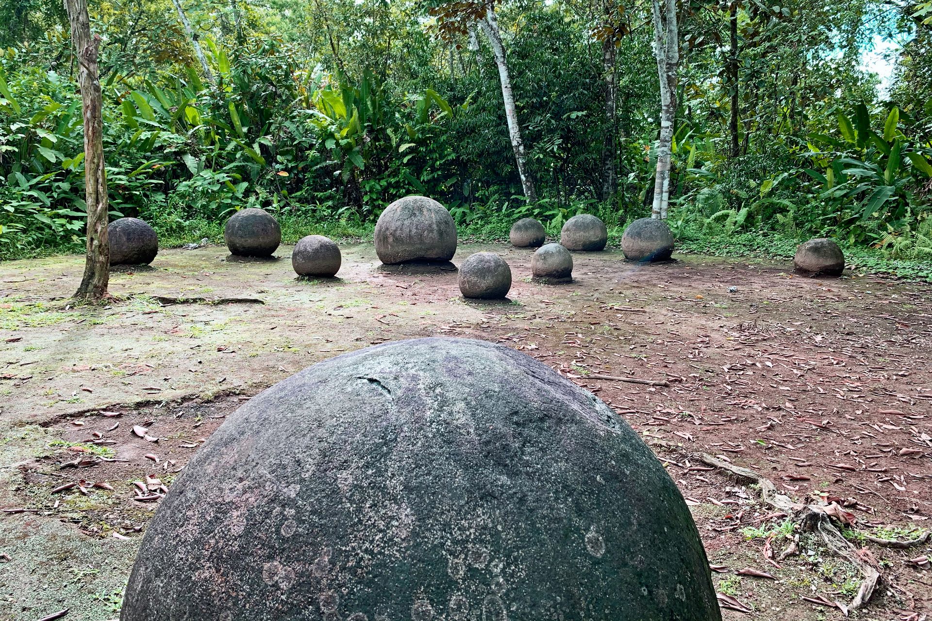
Scattered across the Diquís Delta and the small island of Isla del Caño, off Costa Rica's southern Pacific coast. More than 300 carved stone spheres sit as the main surviving legacy of the Diquís culture. Flourished in the region from roughly 200 BCE until Spanish contact in the 1500s. Locally called bolas de piedra, or stone balls, the spheres range from a few centimeters across to the largest documented example. Measures 2.66 meters in diameter and weighs approximately 24 tons.
The Diquís shaped these spheres from gabbro and granite-like stone, and occasionally limestone, without any metal tools. The process, reconstructed by archaeologists through close study of unfinished examples, involved controlled fracturing of raw boulders. Careful pecking with stone hammers followed, then a long final polish using sand. In several cases, the raw stone came from deposits several miles from where the finished sphere was ultimately placed. It was transported that distance by a culture with no wheeled vehicles and no draft animals.
The Diquís left no written language behind. By the time Spanish forces explored the region in the 1500s, disease had already devastated the population. A 1570 expedition found the communities that once produced the spheres already gone. That absence of records, combined with the fact that many spheres have since been hauled away over the centuries to decorate gardens. Office buildings and even the grounds of the national congress, has made it difficult to reconstruct their original arrangement. With it, their original purpose.
Leading theories include that the spheres marked the residences or status of local chiefs, that they lined ceremonial or processional routes, or that certain alignments carried astronomical significance. This last idea remains contested. Smaller spheres found in burial contexts may have served as personal grave goods. None of these explanations has been proven to the exclusion of the others. The sites were inscribed as a UNESCO World Heritage designation in 2014. Archaeologists from Costa Rica and Mexico were still carrying out conservation work at the main museum site as recently as October 2025. Evidence that the spheres remain an active subject of research rather than a settled one.
Credit: Todd Trapani / Unsplash
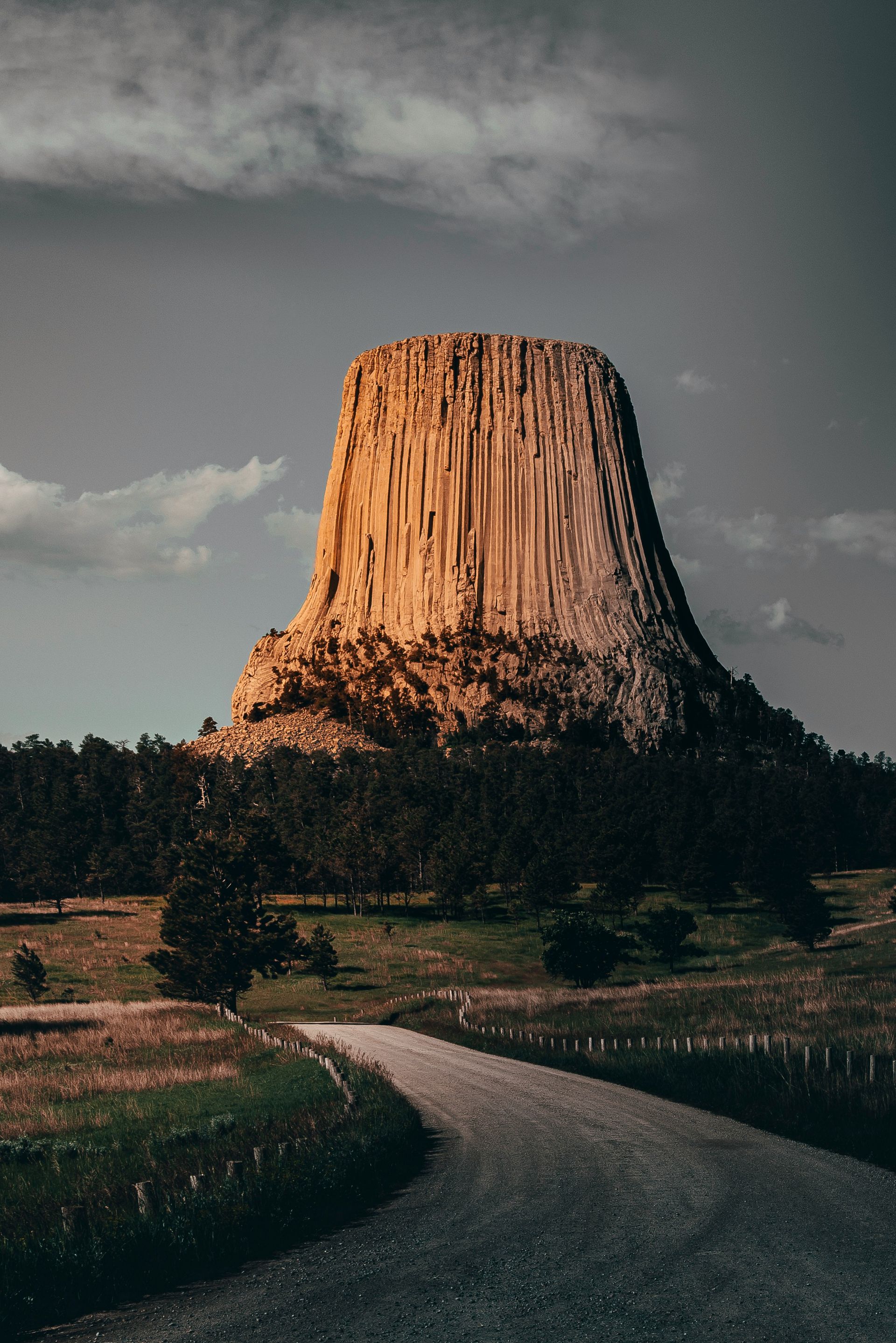
Rising 1,267 feet above the Belle Fourche River in northeastern Wyoming, Devils Tower is built from phonolite porphyry. That igneous rock intruded into the surrounding sedimentary layers roughly 40.5 million years ago. As it cooled, the rock contracted into some of the most striking columnar joints found anywhere on Earth, mostly six-sided and running up to 600 feet tall. The tower its distinctive fluted appearance. It became the first national monument in the U.S. in 1906.
What geologists cannot fully agree on, after more than a century of study, is exactly how that rock got there and what shape it took underground. One long-standing theory holds that Devils Tower is the remnant of a laccolith. A mushroom-shaped body of magma that pushed up beneath the surrounding rock layers without breaking through them, doming the land above before erosion later exposed it. A competing theory describes it as a volcanic neck, the solidified throat of an old volcano that once erupted at the surface. That version runs into a problem: no volcanic ash, lava flow or other eruptive debris of matching age has ever turned up nearby. Is difficult to reconcile with a formation that supposedly once erupted. A third view treats the tower as a simple stock, a smaller and more uniform body of magma that never reached the surface at all. A 2015 study published in the journal Geosphere proposed yet another possibility. That the tower represents a lava flow emplaced within a maar-diatreme volcano, a type of low, broad crater formed when rising magma meets groundwater.
The complication, for geologists, is that the very erosion responsible for revealing Devils Tower also destroyed most of the physical evidence that would settle the debate. Whatever surrounded the rock at the surface when it formed, whether an eruption, a bulging dome, or nothing but buried rock, has long since washed away. Only the resistant core still stands. More than 130 years after the first formal survey of the tower, the U.S. National Park Service's own published geology still describes its precise mode of origin as unresolved.
Credit: Bit Cloud / Unsplash
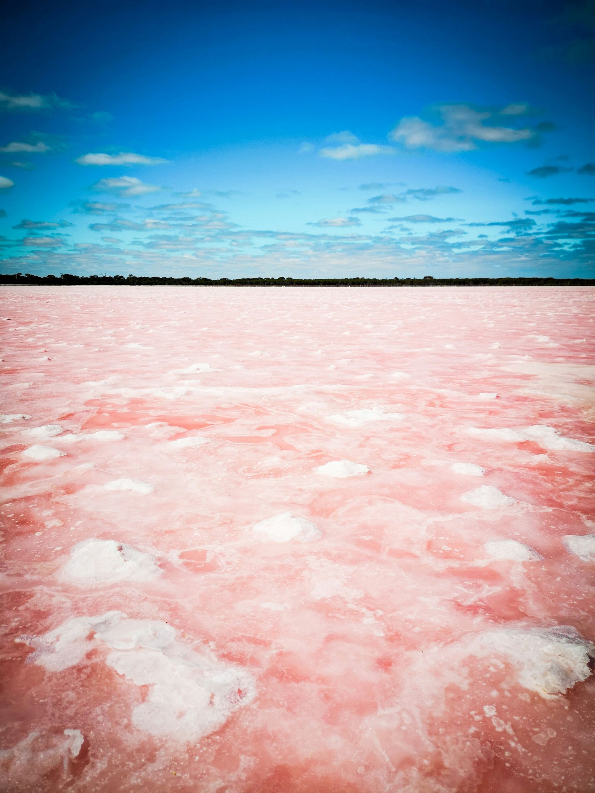
On Middle Island, part of the Recherche Archipelago off Esperance in Western Australia, Lake Hillier holds a shade of pink closer to bubblegum than anything found in nature nearby. The navigator Matthew Flinders recorded it in 1802. The lake has kept its color ever since, separated from the pounding surf of the Southern Ocean by only a narrow strip of dune.
Pink lakes are not unique to Australia, and in most of them, scientists have confirmed the cause with reasonable confidence: a combination of the salt-loving microalga Dunaliella salina. Produces the reddish pigment beta-carotene when stressed by high salt and strong sunlight, along with pigmented, salt-loving bacteria and archaea that contribute their own reddish compounds. Lake Hillier's salinity runs roughly 10 times that of ordinary seawater, similar to the Dead Sea, concentrated enough to support exactly these kinds of organisms. In 2015, researchers with the Extreme Microbiome Project sampled the lake directly. Genetic sequencing confirmed the presence of Dunaliella salina alongside salt-loving microbes including Salinibacter ruber.
What sets Lake Hillier apart from other pink lakes is not the cause, but the consistency of the effect. Most pink lakes shift toward blue or green as temperatures and salinity change with the seasons. Lake Hillier does not. It stays a stable pink year-round and keeps its color even after the water is removed and sealed in a bottle. That persistence has never been fully explained, given how directly the color depends on living organisms responding to their environment. A 2022 genetic study of the lake's full microbial community noted that no research had yet systematically measured exactly how much each organism. The algae versus the various bacteria and archaea, contributes to that specific, unusually stable shade.
The lake's color did fail once. Unusually heavy rainfall in 2022, linked by scientists to a warming climate, diluted the water. That let ordinary green organisms briefly take over, turning the lake blue-gray for a period. Recent visitors report the color returning. That is further evidence that its stability depends on a fairly narrow, still not entirely mapped balance of salt, sunlight and microbial life.
Credit: Andrew Svk / Unsplash
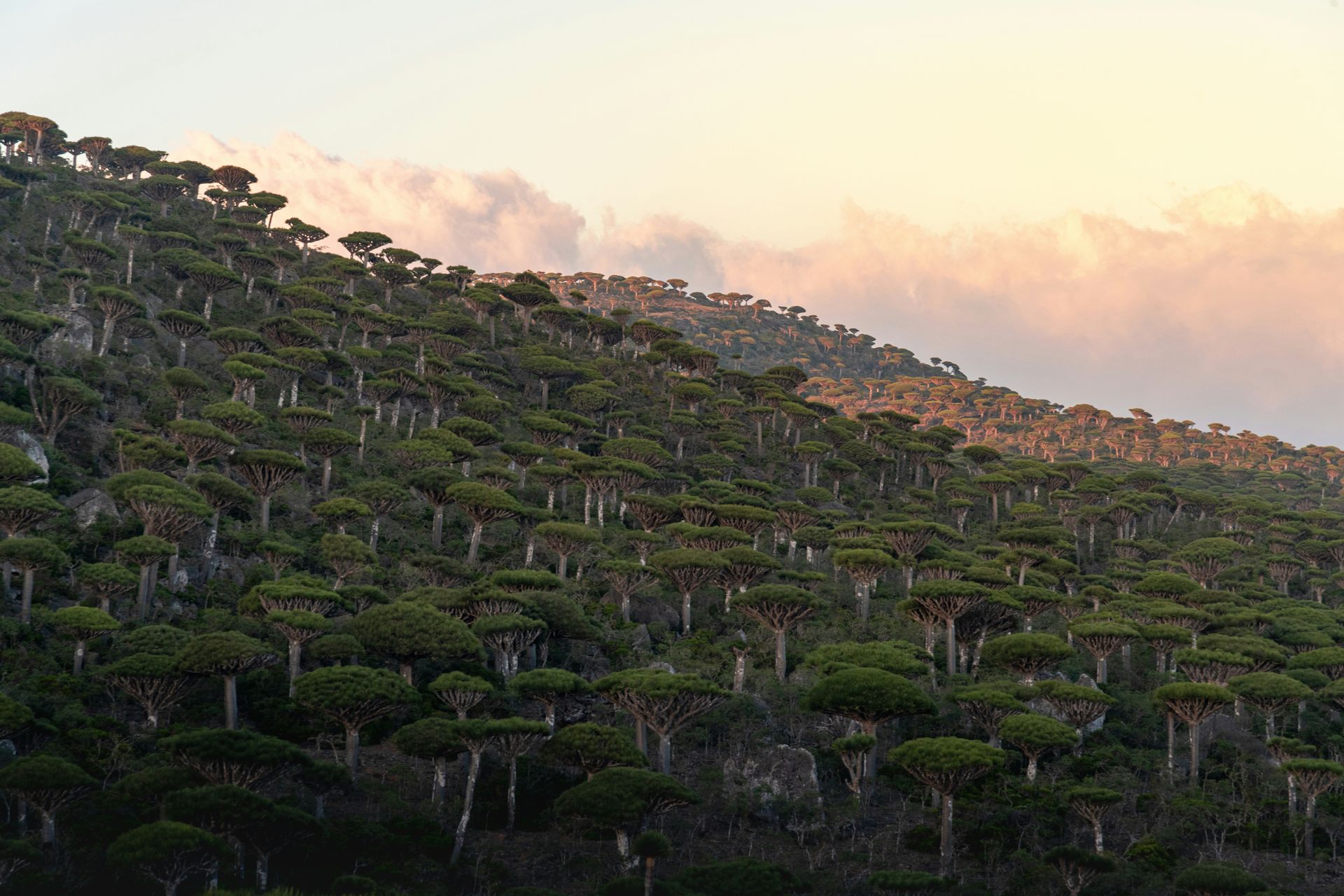
Socotra sits alone in the Arabian Sea, roughly 350 kilometers south of the Arabian Peninsula and 240 kilometers east of the Horn of Africa. Governed by Yemen but separated from it by open water and millions of years of isolation. The main island split away from the ancient supercontinent of Gondwana and then drifted apart from mainland Africa for at least six million years. From the Arabian Peninsula for possibly 20 million years, leaving its plants and animals to evolve largely on their own.
The results are visible from the moment visitors land. Of the roughly 825 plant species documented on the archipelago, about 37 percent exist nowhere else in the world. More than 90 percent of its reptiles and land snails are similarly unique to the island, alongside close to a dozen endemic bird species. The dragon's blood tree, with its inverted, umbrella-shaped canopy and dark red resin, is the most recognizable of these. One of the last surviving members of a much older group of plants that has largely disappeared from the rest of the planet. Nearby grow the bottle-trunked cucumber tree and several wild species of frankincense, along with an endemic subspecies of desert rose that covers the island's canyons in pink blooms each spring.
Long isolation and high endemism are well understood in general terms. Islands cut off from the mainland routinely produce unique species, the same principle behind the biodiversity of the Galápagos. That is why researchers frequently describe Socotra as the Galápagos of the Indian Ocean. What is still being actively researched, species by species, is the more specific history behind each lineage. For some of Socotra's plants and animals, researchers are still working out whether a given species is a true relict. A survivor stranded on the island since it broke away from the mainland, or a more recent arrival that reached Socotra later by crossing open water. Both patterns show up across the archipelago's biology and each requires different evidence to confirm.
That distinction matters for understanding evolution more broadly. Is part of why Socotra functions as a natural laboratory. A relatively uncomplicated, still-isolated setting where biologists can test ideas about how species colonize, adapt and sometimes simply outlast the mainland relatives that gave rise to them.
