Satellite photos reveal how Mumbai killed its rivers and mangrove forests to risk epic floods
It’s almost a ritual: At least on one day every year, the heavens above Mumbai open up, and the metropolis of some 20 million below is inundated.
It’s almost a ritual: At least on one day every year, the heavens above Mumbai open up, and the metropolis of some 20 million below is inundated.
It’s almost a ritual: At least on one day every year, the heavens above Mumbai open up, and the metropolis of some 20 million below is inundated.
The resultant outrage, inconvenience, and suffering are something of a tradition, with successive governments getting pilloried for their lack of preparedness despite the regularity with which the monsoon paralyses India’s financial capital. Some things never change.
The latest act was on Aug. 29, when Mumbai ground to a near-complete halt once again after parts of the city received 298 mm of rain within a nine-hour period. Five people have died so far, and more rain is expected.
The city’s inability to weather such downpours is a result of a combination of the failure to improve its drainage system and the unbridled development that has stymied the region’s natural capacity to absorb heavy rainfall. The latter, in particular, has mostly been overlooked. As journalist Darryl D’Monte noted in Scroll.in:
…Mumbai’s major nullahs form a vein-like network that can extend for an astounding 300 km. These could have functioned effectively to drain water out of the city. But this is a natural legacy that the city authorities have abused, with the reckless sanctioning of building after building, in brazen collusion with builders and venal bureaucrats. By indiscriminately dumping waste in open drains, citizens have also contributed to choking them.
To better understand the impact of the decades of haphazard development, Quartz pulled out some satellite maps of Mumbai from 1988 and 2017:
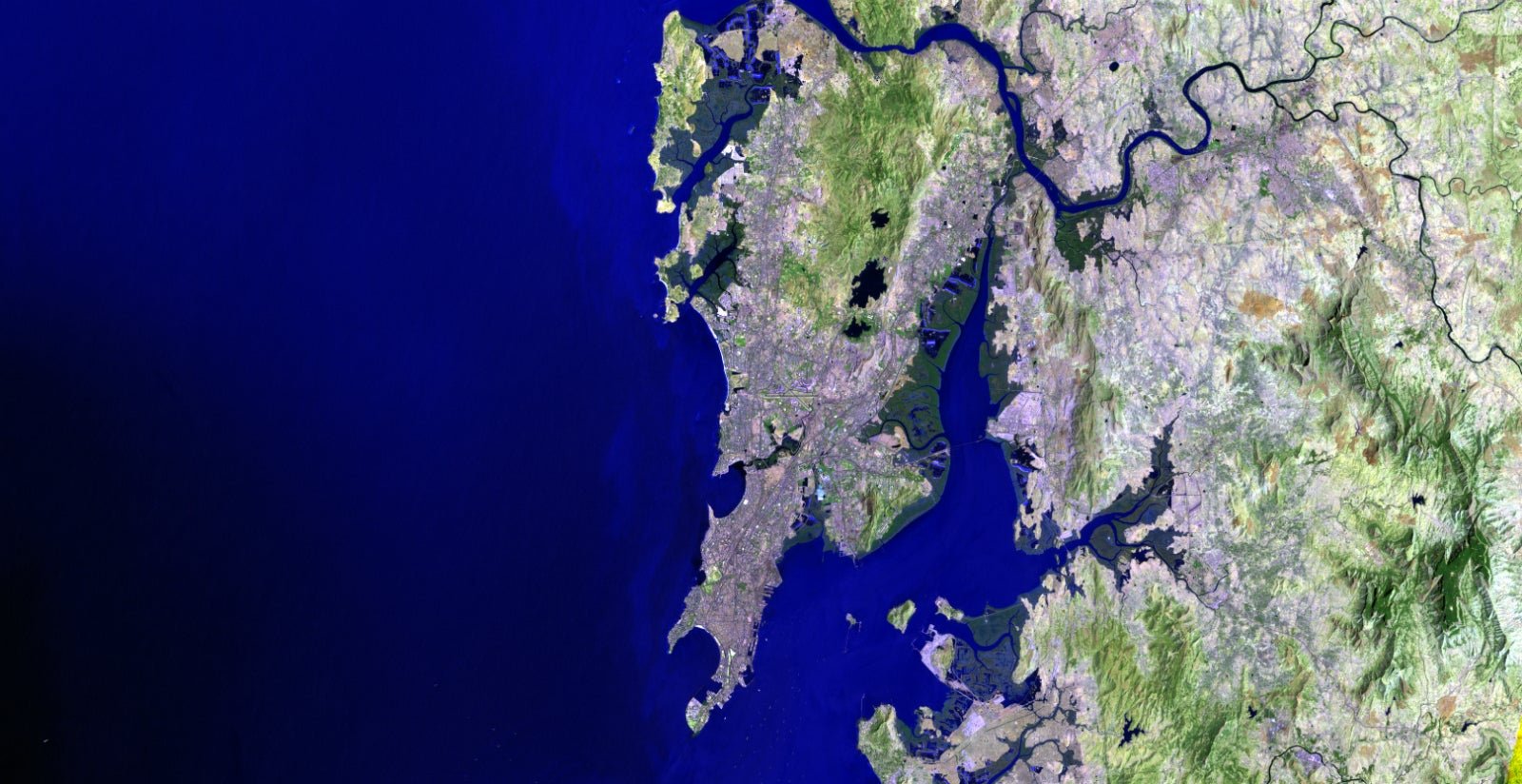
Mumbai is essentially a peninsula jutting into the Arabian Sea. Since the 1980s, when a little over eight million called it home, the city’s population has more than doubled. That’s led to rapid urbanisation of the surrounding areas, as well as encroachment of the mangroves on the city’s edges.
A close examination of mangroves around the Thane (the finger of water on the right) and Malad creeks (the green patch on the left) reveal how the city has expanded. Mangrove forests, found at the intersection of land and sea, are natural and vital flood barriers, especially as storms become more erratic and severe due to climate change.
More proof of their destruction is available further north of Mumbai, where the area around the Manori creek (on the left) has been massively encroached upon. Mangroves at the mouth of the Desai Khadi river (bottom, right), too, have met with a similar fate, with areas being extensively built upon in the last 30 years.
Then, there’s the Mithi river, the thread of blue at the centre of the image, right under the X $TWTR-shaped runways of the Mumbai airport. It originates in the hills around the Sanjay Gandhi National Park and travels nearly 18 kilometres to drain into the sea. Mithi is Mumbai’s natural storm drain, particularly during heavy rains. Over the years, though, it has become a veritable sewer, choked with domestic and industrial waste. The wetlands along the river (immediately south of the airport), too, have disappeared since the late 1980s.
It’s a story of maximum destruction in the Maximum City.
Join 500,000+ readers who start their day with Quartz.
By subscribing, you agree to our Terms of Service and Privacy Policy.