
From a flood tunnel under Tokyo to a rotating boat lift in Scotland, these 20 working structures draw travelers for the engineering alone
Credit: Alexander Sinn / Unsplash
Most infrastructure is designed to disappear. A water main that works is a water main nobody thinks about, and the highest compliment a sewer system can receive is silence. Yet a small class of structures refuses to stay invisible. They are so large, so old, so strange or so well made that people travel across the world just to stand in front of them. The Hoover Dam receives millions of visitors a year, and none of them come for the electricity. The Pont du Gard stopped carrying water more than a thousand years ago, and tourists still line up to walk beneath it. A suspended monorail in a mid-sized German city has been running since 1901, and riding it remains the main reason outsiders visit Wuppertal at all.
This kind of travel has a logic of its own. Museums curate objects and theme parks manufacture experiences, but a dam or a storm surge barrier was never built to please anyone. Its scale is honest. The 59 concrete pillars under the Tokyo suburbs exist because engineers calculated that the region's rivers needed them, not because a designer thought they would photograph well. That indifference is precisely what makes these places compelling. Visitors get to see what a society decided was worth an enormous amount of money, labor and risk — flood protection, clean water, a faster route across a valley — rendered in steel and concrete at a scale no exhibit can fake.
The 20 places on this list span five continents and roughly 2,000 years of construction. Some are ancient Roman aqueducts that still stand without mortar. Some are active facilities where hard hats are mandatory and tours sell out weeks in advance. A few, like New York's High Line, are pieces of infrastructure that outlived their original purpose and found a second life as public space. All of them share one trait: the attraction is not a view, a beach or a collection. The attraction is the thing itself — the machine, the span, the tunnel — and the human decision to build it.
Credit: Pixabay / Pexels
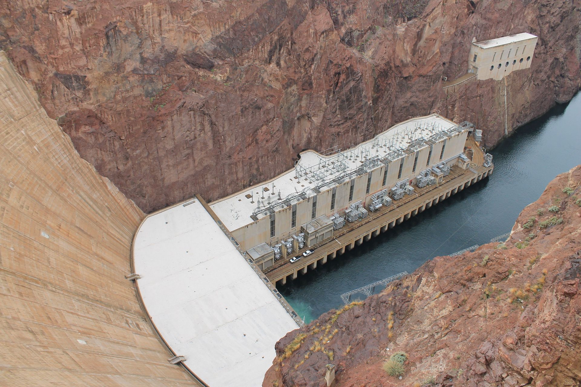
The Hoover Dam is the rare piece of federal infrastructure with its own gift shop, parking garages and a visitor center carved into a canyon wall. Completed in 1936 on the Colorado River, the dam sits on the border between Nevada and Arizona, about 30 miles from Las Vegas, and remains one of the most visited engineering sites in the U.S.
The structure is 726 feet tall, and its curved concrete face holds back Lake Mead, the largest reservoir in the country by capacity. Construction took place during the Great Depression and finished ahead of schedule, a fact the on-site tours emphasize alongside the harder history: thousands of workers labored in extreme heat, and more than 90 died during the project.
Visitors can choose between two experiences. The Powerplant Tour descends into the dam by elevator and walks through the generator hall, where turbines convert the river's flow into electricity for Nevada, Arizona and California. The longer Dam Tour adds passage through the original inspection tunnels drilled into the concrete itself, including a ventilation shaft that opens directly onto the dam's face.
The design rewards attention beyond the raw scale. The Bureau of Reclamation hired artists during construction, and the result is an Art Deco monument as much as a utility. Winged bronze figures flank a terrazzo plaza on the Nevada side, and even the intake towers rising from Lake Mead carry sculptural detailing.
The Mike O'Callaghan–Pat Tillman Memorial Bridge, opened in 2010 to carry highway traffic that once crossed the dam's crest, added a second attraction. A pedestrian walkway on the bridge gives visitors a full view of the dam from nearly 900 feet above the river — a vantage point that did not exist for the structure's first 74 years. Admission to the visitor center and both tours is ticketed, and the more extensive Dam Tour is limited to small groups that often sell out on busy days.
Credit: an yang / Unsplash
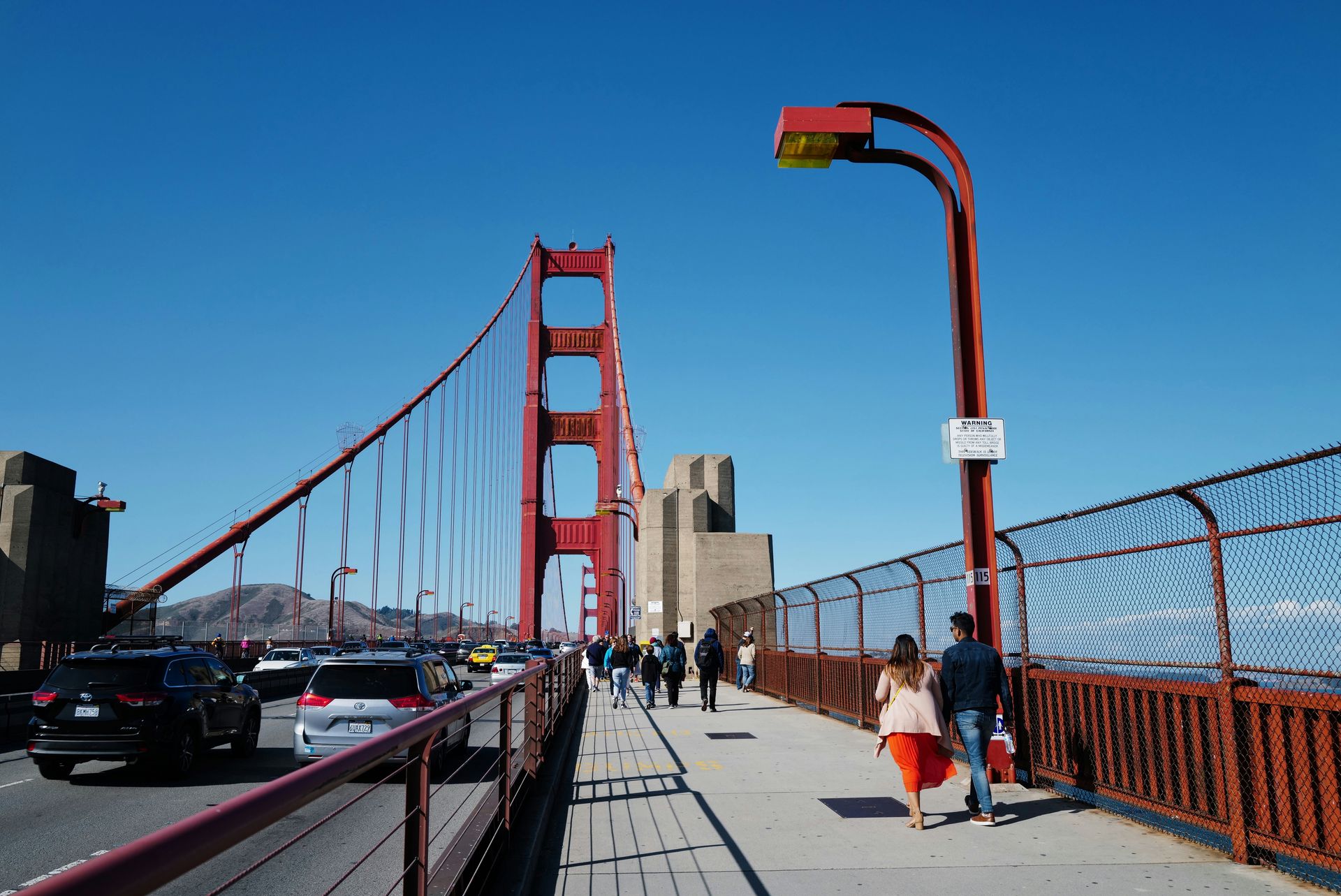
Plenty of cities have a suspension bridge. San Francisco has the one that other suspension bridges get compared to. The Golden Gate Bridge opened in 1937 after four years of construction across a strait known for fog, tides and wind, conditions that many engineers of the era considered disqualifying.
The main span stretches 4,200 feet between two towers that rise 746 feet above the water, and for more than two decades it was the longest suspension span in the world. The color is as engineered as the cables. International Orange was chosen partly because it remains visible in fog, and the bridge district maintains it continuously — painting the bridge is not a one-time event but a permanent maintenance program.
The bridge functions as a working commuter route carrying roughly 100,000 vehicles on a busy day, but it is also built for visitors in a way few highways are. Sidewalks run the full 1.7-mile length, with the east side reserved for pedestrians during daytime hours and the west side for cyclists. Walking across takes most people around 35 to 45 minutes each way, and the middle of the span offers views of Alcatraz, the city skyline and the Marin Headlands.
A welcome center at the southern end covers the construction story, including the safety net suspended under the deck during building. The net saved 19 men, who formed an informal club called the Halfway to Hell Club.
The best land-based viewpoints are attractions in themselves. Battery Spencer in the Marin Headlands puts visitors nearly at tower height, and Fort Point, a Civil War-era fortress, sits directly beneath the southern anchorage, where the arch above it was added specifically to preserve the old fort. Fog is part of the experience rather than a flaw. Summer mornings often hide the towers completely, and the bridge's foghorns still sound to guide ships through the strait below.
Credit: Edwin Stanley Portillo Rodriguez / Pexels
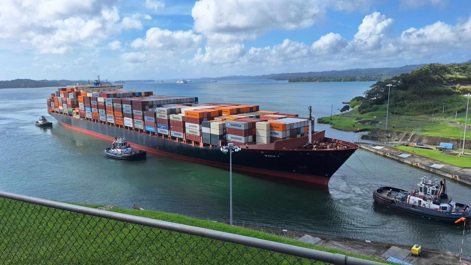
The Panama Canal turned an 8,000-mile voyage around South America into a 50-mile shortcut, and it has been drawing sightseers since it opened in 1914. The appeal is watching physics do heavy lifting. Ships entering from the Pacific are raised 85 feet through a series of lock chambers to Gatun Lake, cross the isthmus, and are lowered back to sea level on the Atlantic side.
The Miraflores Visitor Center, a short drive from Panama City, puts spectators on observation decks directly beside the original 1914 locks. Timing matters: large vessels typically transit Miraflores in the morning and afternoon windows, and the center posts expected passage times. Watching a ship rise in the chamber is slow, deliberate theater — the gates close, the water level climbs, and a vessel weighing tens of thousands of tons floats upward with no pumps involved, since the entire system runs on gravity-fed water from the lake.
Electric locomotives called mules run along the lock walls, keeping ships centered in chambers that sometimes leave only a couple of feet of clearance on each side. The precision is part of the show.
A 2016 expansion added a third set of locks large enough for so-called Neopanamax vessels, and with it a second viewing site: the Agua Clara Visitor Center near Colón on the Atlantic side, which overlooks the new chambers and Gatun Lake.
Visitors who want more than a viewing deck can book partial transit cruises that pass through the locks themselves, usually on weekends. The canal also shaped the country around it, and the railway line that parallels the waterway — the first transcontinental railroad in the Americas, completed in 1855 — offers a one-hour crossing between the two oceans. Both visitor centers include museums covering the construction era, when disease and accidents killed thousands of workers across the failed French attempt and the American project that followed.
Credit: juv / Pexels
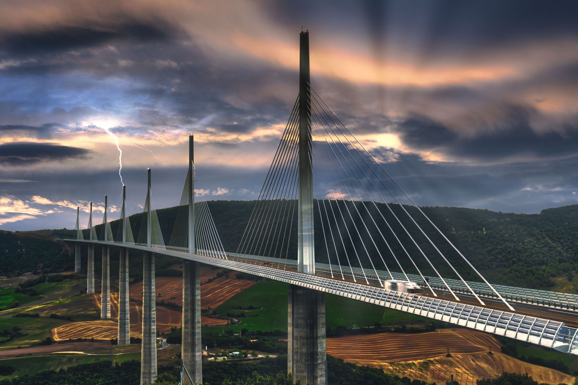
The Millau Viaduct crosses the Tarn valley in southern France, and at its highest point the roadway hangs roughly 270 meters above the river — high enough that drivers sometimes cross above the clouds. The tallest of its seven masts reaches 343 meters, which makes the structure taller than the Eiffel Tower and the tallest bridge in the world since it opened in 2004.
The project paired British architect Norman Foster with French engineer Michel Virlogeux, and the result looks less like a highway and more like a set of sails strung across the valley. The deck runs about 2.5 kilometers, carried by slender pylons and fans of cable stays, with a slight curve that was added deliberately so drivers can see the structure ahead of them as they cross.
The viaduct exists for a practical reason. The A75 motorway funnels summer traffic between Paris and the Mediterranean, and before 2004 that traffic descended into the town of Millau and crawled through legendary bottlenecks. The bridge removed the detour entirely, cutting the crossing to about a minute.
Then something unplanned happened: the bypass became a destination. A visitor area on the north side of the valley includes an exhibition about the construction, which involved sliding the steel deck out from both sides of the valley on hydraulic rams until the halves met in the middle with an accuracy measured in millimeters.
The town of Millau, which feared being forgotten once traffic stopped passing through, now markets itself around the bridge. Viewpoints dot the surrounding hills, kayak rentals on the Tarn let visitors drift beneath the piers, and local operators run guided tours to the base of the pylons, where the scale of the concrete becomes physical rather than photographic. Toll plazas sit at either end, and the crossing remains part of an ordinary working motorway rather than a standalone monument, which is much of the point.
Credit: Clément Proust / Pexels
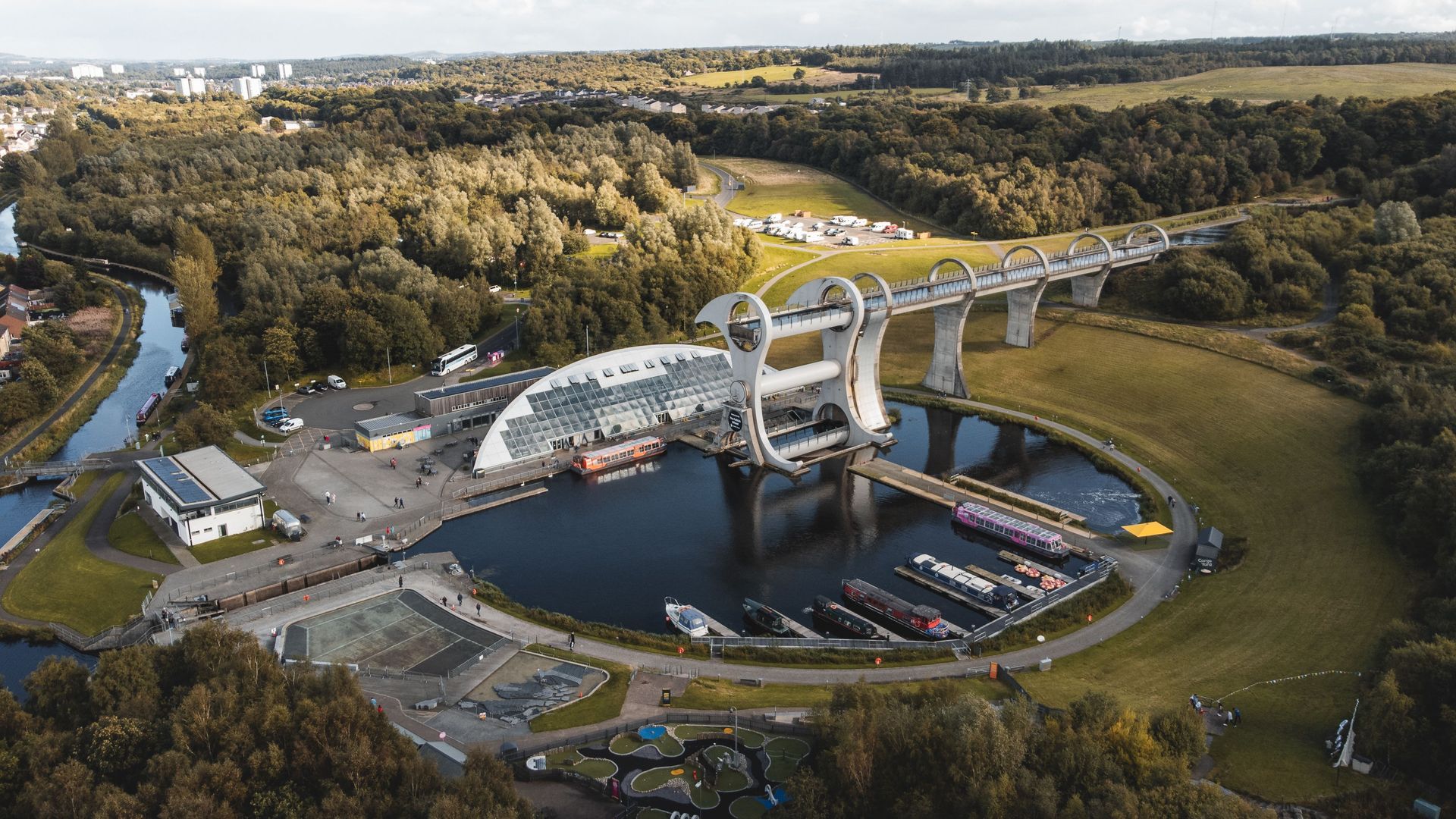
Canals connect at different elevations all over the world, and the standard solution is a staircase of locks. Central Scotland built a Ferris wheel for boats instead. The Falkirk Wheel, opened in 2002, is the world's only rotating boat lift, and it exists to join the Forth and Clyde Canal with the Union Canal, which sits 24 meters higher.
The two canals once connected through a flight of 11 locks, a passage that took most of a day and was abandoned in the 1930s. When Britain restored the canal link at the turn of the millennium, engineers replaced the locks with a single rotating structure: two water-filled gondolas mounted on opposite ends of giant arms. A boat sails into the lower gondola, the gates close, and the entire wheel turns 180 degrees, lifting the vessel to the upper canal in a few minutes.
The physics is the quiet star of the attraction. Because the gondolas always carry the same combined weight — a floating boat displaces exactly its own weight in water, so a full gondola and an empty one balance — the wheel stays in equilibrium no matter what it carries. Rotating it requires only a small amount of electricity, comparable to running ordinary household appliances rather than industrial machinery.
Scottish Canals operates the site as a visitor attraction with boat trips that ride the wheel up, cruise a short stretch of the Union Canal and rotate back down. The trip includes passage through a tunnel bored beneath the Antonine Wall, the Roman frontier fortification that crosses the site.
The wheel anchors a broader canal revival. The Kelpies, a pair of 30-meter steel horse-head sculptures, stand a few miles away at the canal's eastern gateway, and a towpath links the two sites for walkers and cyclists. Access to the surrounding park, towpaths and viewing areas is free; only the boat trips onto the wheel itself require tickets.
Credit: AMANO Jun-ichi / Anefo / Wikimedia Commons (CC BY 3.0)
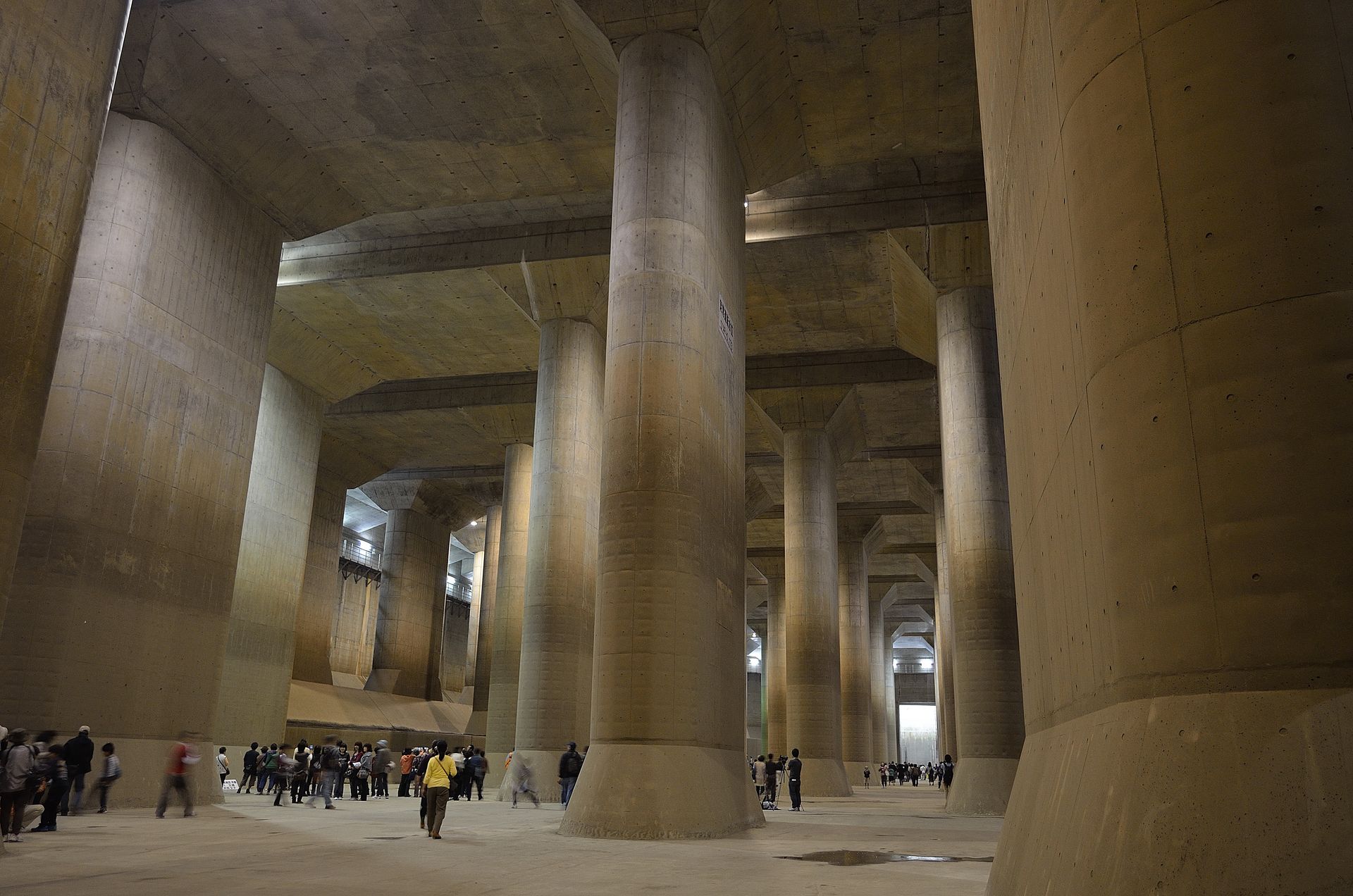
Beneath the suburbs north of Tokyo sits a room that visitors routinely compare to a temple: a vast underground hall where 59 concrete pillars, each about 18 meters tall, rise from a floor the size of a sports field. It is not a temple. It is a surge tank, the final chamber of the Metropolitan Area Outer Underground Discharge Channel, one of the largest stormwater diversion systems on Earth.
Completed in 2006 in Kasukabe, Saitama prefecture, the system exists because the low-lying plain around Tokyo floods. Five enormous vertical shafts, each deep enough to swallow a mid-rise building, collect overflow from local rivers during typhoons and heavy rain. A tunnel more than six kilometers long carries the water underground to the main tank, where pumps powerful enough to drain a swimming pool in seconds push it into the Edo River.
The pressure-adjusting tank — the pillared hall — measures 177 meters long, 78 meters wide and about 25 meters high. When the system is dry, which is most of the time, the operator opens it to the public. Guided tours descend a long staircase into the hall, and the experience is disorienting in a specific way: everything looks like a video game set or a science fiction backdrop, and film crews have used it as exactly that.
Booking requires planning. Tours are run in Japanese, fill up in advance, and are canceled whenever rain threatens, since the facility's actual job takes priority over tourism. Several tour tiers exist, including options that visit the pump room and peer down into one of the giant shafts.
The site has become an unlikely emblem of a broader Japanese specialty — disaster infrastructure built at monumental scale — and it draws engineering students, photographers and travelers who have seen the pillared hall online and want to confirm it is real.
Credit: Flávia Sandriany / Pexels
The Itaipu Dam spans the Paraná River on the border between Brazil and Paraguay, and it holds a distinction that surprises people who assume China's Three Gorges dominates every hydropower category: in several years, Itaipu has produced more electricity annually than any other dam in the world, thanks to the Paraná's steady year-round flow.
The numbers define the visit. The main dam and its associated structures stretch for kilometers across the river valley, the structure rises about 196 meters, and 20 generating units give the plant an installed capacity of 14,000 megawatts. The output supplies the large majority of Paraguay's electricity and a meaningful share of Brazil's, split between the two countries under a treaty that governs the binational entity operating the dam.
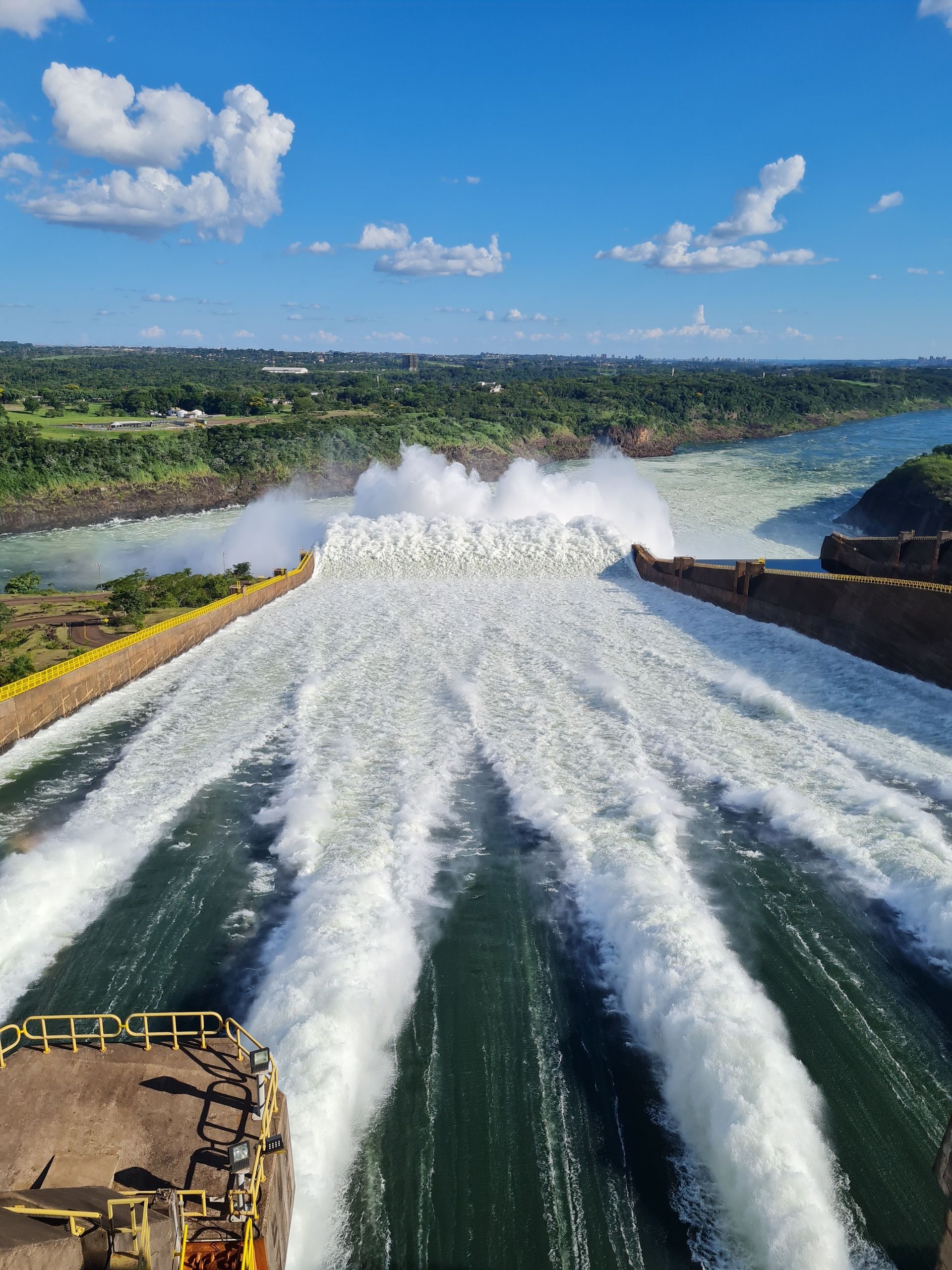
Itaipu has treated tourism as part of its mission since construction. The dam sits near Foz do Iguaçu, the Brazilian city that serves as the gateway to Iguazú Falls, so a steady stream of travelers is already in the area, and many add the dam as a second stop. Panoramic bus tours cross the top of the structure and stop at viewpoints over the spillway, which puts on its own show when water releases are underway.
The technical tour goes further, taking visitors inside the plant to the central control room — where a painted line on the floor marks the Brazil–Paraguay border between the two operating teams — and down to the turbine level, where the scale of a single generating unit becomes clear.
The dam also runs an ecological complex, including a wildlife refuge and reforestation zones along the reservoir, part of an effort to offset the flooding of the Guaíra Falls, a massive waterfall system submerged when the reservoir filled in 1982. Reservations are recommended in peak season, and tours depart from visitor complexes on both the Brazilian and Paraguayan sides of the border.
Credit: Michielverbeek / Wikimedia Commons (CC BY-SA 3.0)
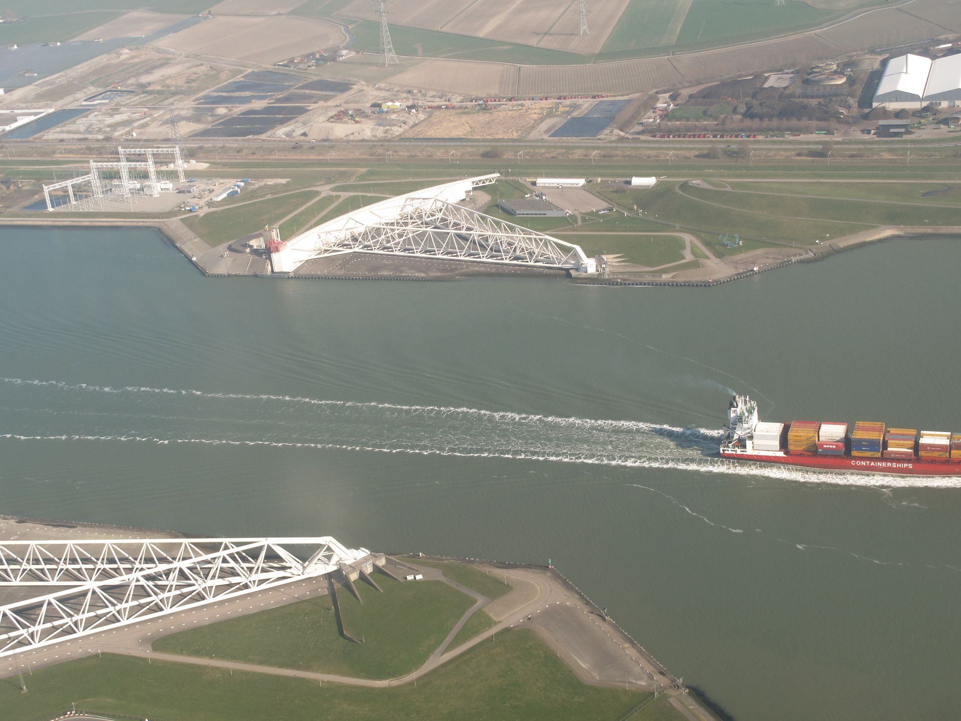
The Netherlands has spent centuries negotiating with the sea, and the Maeslantkering is the most theatrical clause in the agreement. It is a storm surge barrier guarding the entrance to the port of Rotterdam: two enormous white steel arms, each anchoring a curved gate about 210 meters long, resting in dry docks on opposite banks of the Nieuwe Waterweg canal.
Most of the time, the barrier does nothing. Ships pass freely, because Rotterdam is one of the busiest ports in the world and closing the channel is economically painful. When a dangerous storm surge is forecast, a computer system makes the call. The docks flood, the two arms swing out across the 360-meter-wide waterway like a pair of closing gates, the hollow gates fill with water and sink onto a foundation on the canal bed, and the port is sealed against the North Sea.
The structure, completed in 1997, was the finishing piece of the Delta Works, the flood defense program the Netherlands launched after the 1953 North Sea flood killed more than 1,800 people. Each swinging arm is comparable in length to the Eiffel Tower laid on its side, and the ball joints on which the arms pivot rank among the largest in the world.
Visitors come to a place that hopes never to perform. The Keringhuis, a public information center beside the barrier, explains Dutch water management and offers guided tours along the structure itself, where the scale of the trusses reads more like shipbuilding than civil engineering.
The best time to visit is late September, when the barrier undergoes its annual test closure before storm season. The event is public, announced in advance, and draws crowds who watch the arms swing shut across the canal in an operation that takes about two and a half hours. The Keringhuis also covers the wider Delta Works, whose dams and barriers across the Zeeland delta can be visited on a longer regional itinerary.
Credit: Laurin Berli / Pexels
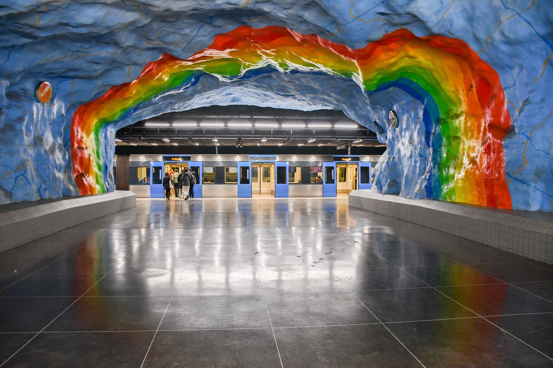
Stockholm's transit authority describes its metro as the longest art gallery in the world, and the claim holds up on inspection: the network runs about 110 kilometers, and more than 90 of its 100 stations contain commissioned artwork — sculpture, mosaics, paintings, installations — accumulated since the 1950s, when the city decided public art belonged in public transit.
The stations that draw tourists sit mostly on the Blue Line, where a construction choice became an aesthetic. Rather than lining the tunnels with smooth panels, engineers left the excavated bedrock exposed and sprayed it with concrete, producing cave-like halls with organic, uneven ceilings. Artists then painted directly onto the rock.
Rådhuset station glows in warm terracotta tones that make the platform feel like the inside of a canyon. Solna Centrum is painted a saturated red and green, with a kilometer-long spruce forest silhouette and scenes addressing 1970s Swedish social debates, from rural depopulation to environmental damage. T-Centralen, the system's central hub, features a Blue Line platform covered in calming blue vines and leaves, painted with commuter stress in mind, along with silhouettes honoring the workers who built the station.
Kungsträdgården, the eastern terminus of the Blue Line, functions as an underground archaeological garden, with sculpture fragments, columns and pieces salvaged from demolished Stockholm buildings arranged among the painted rock. The station is also known among biologists for hosting cave-adapted organisms in its damp corners, a detail the transit authority acknowledges with some pride.
Seeing the highlights requires nothing more than a standard travel pass, which makes this one of the cheapest attractions on this list. The transit authority also runs free guided art walks at certain times of year. Visitors with one spare hour and a zone ticket can cover four or five of the signature stations simply by riding the Blue Line and stepping off.
Credit: Ramaz Bluashvili / Pexels
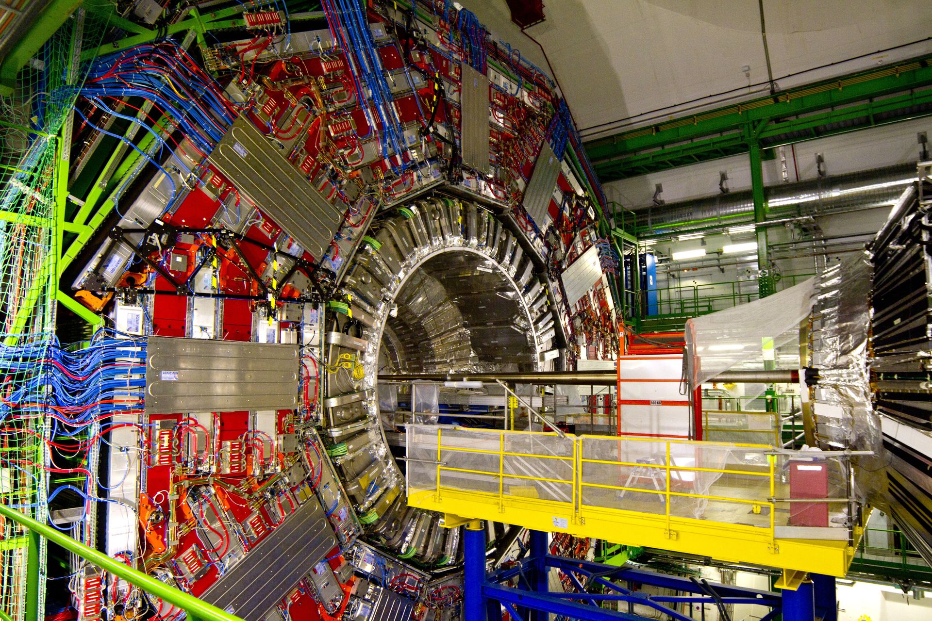
The largest machine ever built is a ring 27 kilometers around, buried about 100 meters beneath the countryside straddling the border between Switzerland and France. The Large Hadron Collider accelerates protons to nearly the speed of light and smashes them together so physicists can study the debris — work that led to the 2012 confirmation of the Higgs boson.
CERN, the European laboratory that operates the collider, has built a serious public-facing operation around its science. The Science Gateway, an exhibition and education center designed by architect Renzo Piano, opened on the Geneva campus in 2023, with free admission and exhibits that include real accelerator components, immersive installations and live demonstrations. It joined the Globe of Science and Innovation, the wooden sphere that has served as CERN's public landmark for two decades.
Guided tours, also free, take visitors into working areas of the laboratory, though access to the underground collider tunnel itself is generally limited to shutdown periods when the machine is not running. Tour content varies, but stops can include the CERN Control Centre, a test facility for accelerator magnets or the surface buildings above the big detectors. Demand consistently outstrips supply, and reservations open weeks ahead.
Part of the site's appeal is historical rather than physical. CERN is where Tim Berners-Lee invented the World Wide Web in 1989, originally as a tool for sharing physics data, and a plaque and exhibits mark that lineage. The laboratory itself is a diplomatic artifact, founded in 1954 to rebuild European science after World War II, with member states funding research that belongs to no single country.
Visitors cross an international border on-site without noticing. The main campus sits in Switzerland, parts of the ring run under France, and the proton beams commute between the two countries thousands of times per second.
Credit: Carsten Ruthemann / Pexels
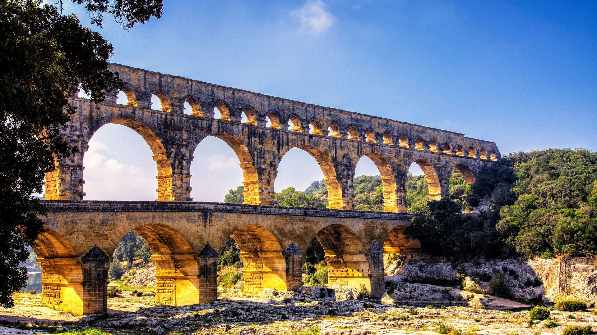
The Pont du Gard is a bridge that never carried a road. It is the tallest surviving section of a Roman aqueduct, built in the first century AD to carry water across the Gardon River on its way to the city of Nîmes in southern France. Three tiers of arches stack nearly 49 meters above the river, and the whole structure was assembled from massive limestone blocks, many set without mortar.
The engineering that matters here is invisible from the riverbank. The aqueduct ran roughly 50 kilometers from a spring near Uzès to Nîmes, and over that entire distance the water dropped only about 12 meters. Roman surveyors maintained a gradient averaging a few centimeters per hundred meters using instruments no more sophisticated than water levels and sighting tools. The channel that crosses the top of the Pont du Gard is part of that continuous, almost imperceptible slope.
The aqueduct fell out of use in the early Middle Ages, but the bridge survived because it stayed useful — for centuries, people simply walked and carted goods across it, and a road bridge was eventually attached alongside the lowest tier in the 18th century. UNESCO listed the site in 1985.
Today the Pont du Gard anchors a managed park with a museum dedicated to Roman hydraulic engineering, covering how the aqueduct was surveyed, built and maintained, and what happened as mineral deposits slowly narrowed the channel over centuries of use. Guided visits sometimes include the interior conduit on the top tier, a passage tall enough to walk through.
The river below doubles as a swimming spot in summer, which produces one of the stranger sights in European tourism: crowds floating on inflatable rafts beneath a 2,000-year-old water main. Evening light shows illuminate the arches in peak season. A footpath on the attached road-bridge level lets visitors cross the river directly alongside the ancient arches in all seasons.
Credit: JOSE BARON / Pexels
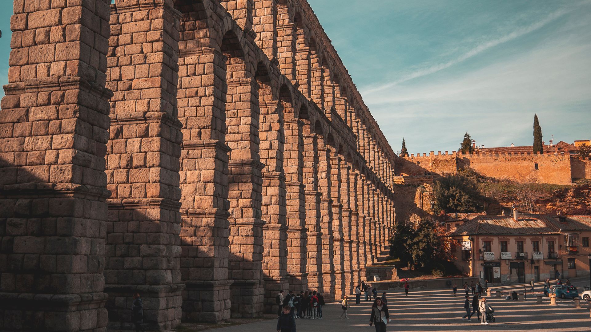
The Aqueduct of Segovia runs straight through the middle of a living city, which is what separates it from most Roman ruins. Its double tier of granite arches marches across the Plaza del Azoguejo in the heart of Segovia, Spain, reaching about 28 meters at its highest point, and residents cross beneath it on their way to work as they have for many centuries.
The structure was likely completed around the end of the first century or the beginning of the second century AD, and it carried water from the Frío River in the mountains roughly 17 kilometers away. The visible monument — the arcade of arches through the city — is only the final stretch of that system, the section needed to keep the water channel elevated as the terrain dipped before rising again to the old town.
The construction method draws engineers as well as tourists. The granite blocks are unmortared, held in place by weight and precise balance, and the aqueduct has survived roughly 1,900 years of weather, wars and urban growth around its foundations. It remained part of Segovia's working water supply into the modern era, an operational lifespan almost no piece of infrastructure on this list will match.
Segovia's old town and the aqueduct were listed together by UNESCO in 1985, and the city treats the monument as its central landmark. A statue of Romulus and Remus near the base nods to the Roman origin, and stairways beside the plaza climb to viewpoints level with the upper arches, where the slight, deliberate gradient of the water channel becomes visible.
The aqueduct pairs naturally with the rest of the city, since Segovia's cathedral and its ship-shaped Alcázar castle sit within walking distance, but the arches are the reason day-trippers make the short high-speed rail journey from Madrid.
Credit: Oskar Gross / Pexels
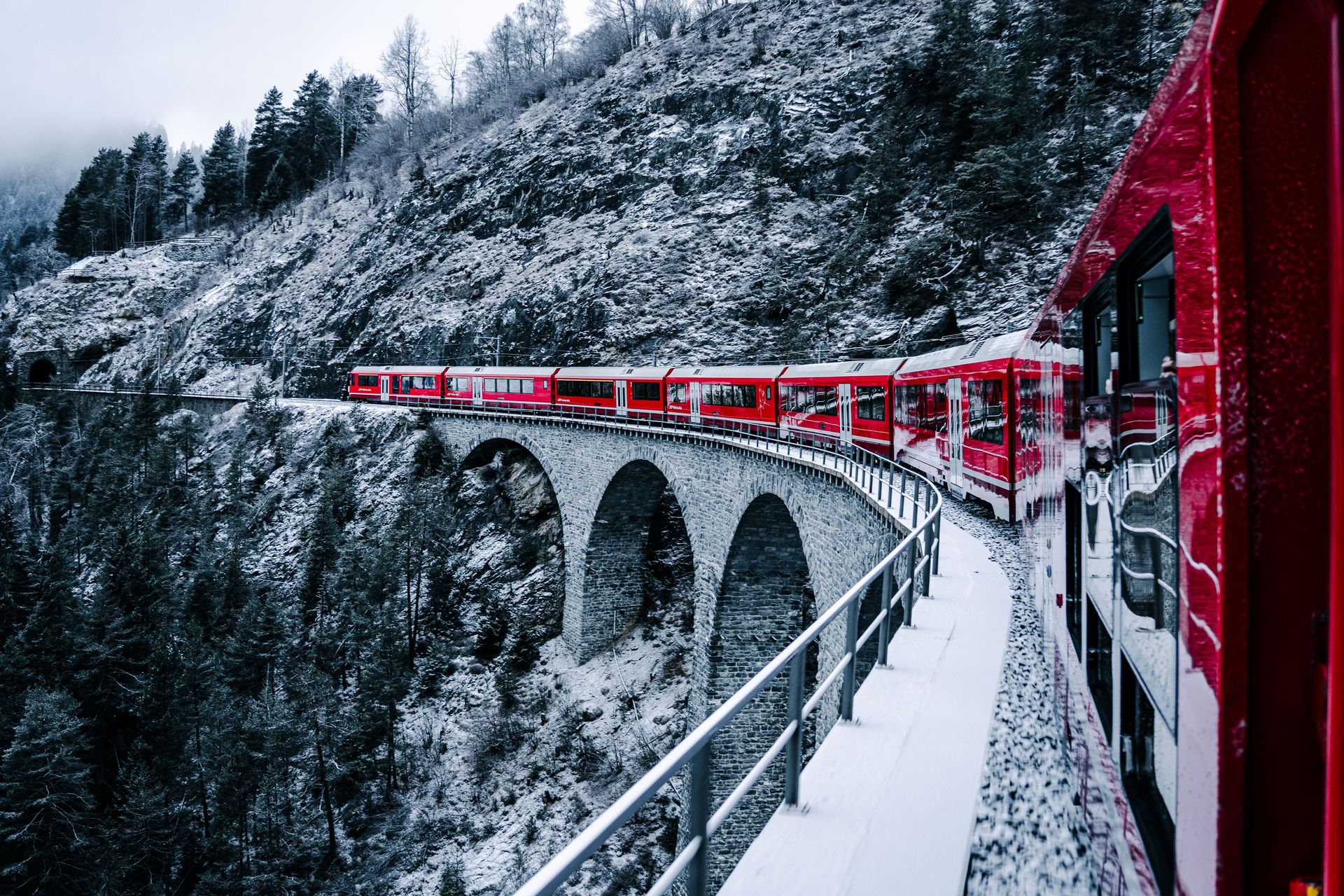
Railways usually earn UNESCO World Heritage status after they stop mattering. The Rhaetian Railway's Albula and Bernina lines received the designation in 2008 while running full daily service, and the Bernina section remains one of the few places where a scheduled public train doubles as a mountain expedition.
The line climbs from Chur, Switzerland's oldest town, over the Bernina Pass and down to Tirano in Italy. At its summit beside the lakes at Ospizio Bernina, the track reaches 2,253 meters above sea level, making it the highest railway crossing of the Alps operated year-round — and it does this without cog wheels or racks, using pure adhesion on gradients as steep as seven percent.
The engineering solutions are the scenery. The Albula section threads a series of spiral tunnels and stacked viaducts that let the train gain altitude inside the mountain, emerging repeatedly above the track it just traveled. The Landwasser Viaduct, a curved stone span that launches directly into a tunnel bored through a cliff face, is the network's signature image. On the Bernina side, the circular viaduct at Brusio loops the train 360 degrees in the open air to lose elevation on the descent toward Italy.
Travelers $TRV can ride the panoramic Bernina Express, which runs the full route with domed windows and seat reservations, or take the ordinary regional trains that cover the same track for standard fares, stop at every village and allow windows that open — a detail photographers care about.
The trip compresses climate zones into hours. Passengers leave palm-lined Tirano at about 430 meters, pass glaciers near the summit and can complete the journey in a single afternoon, crossing a language border from Italian into Romansh- and German-speaking Switzerland along the way. Winter service continues through heavy snow, and the image of the small red train crossing white passes has become the railway's calling card.
Credit: Grzegorz Kowalczyk / Pexels
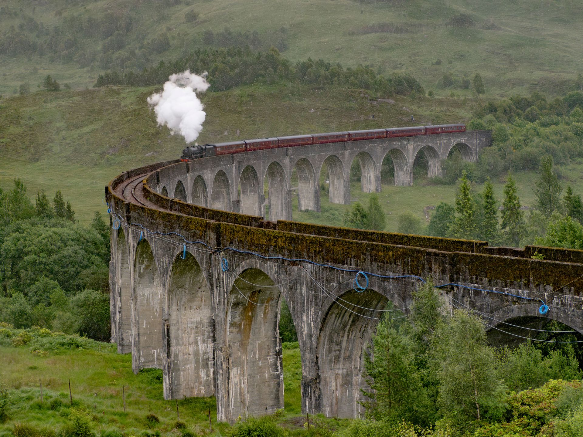
The Glenfinnan Viaduct curves across a Highland valley at the head of Loch Shiel in western Scotland, and its 21 concrete arches have appeared on Scottish banknotes, in countless photographs and, most consequentially for its visitor numbers, in the Harry Potter films, where the Hogwarts Express crosses it on the way to school.
The structure predates its fame by a century. It was built for the West Highland Line's extension to Mallaig and opened in 1901, and it was an early large-scale use of mass concrete — concrete without steel reinforcement — in British railway construction. The contractor, Robert McAlpine, earned the nickname Concrete Bob for championing the material, which suited a remote site where transporting stone would have been costly. The viaduct stands about 30 meters above the valley floor and stretches roughly 380 meters on a continuous curve.
The railway still runs. Scheduled trains between Fort William and Mallaig cross daily, and in the warmer months the Jacobite steam service — the train that played the Hogwarts Express — crosses the viaduct with a locomotive trailing smoke, which is the moment thousands of visitors climb the hillside trails to photograph.
The site has had to adapt to its own popularity. A viewpoint trail from the Glenfinnan visitor center leads to the classic angle overlooking the arches and the loch, and parking in the small village fills early on summer days, with rangers managing overflow.
The valley carries older history as well. The Glenfinnan Monument at the loch shore marks the spot where Bonnie Prince Charlie raised his standard in 1745, launching the Jacobite rising — the event the steam train's name references. Visitors who time it right can watch a steam train cross a 1901 viaduct above an 18th-century battlefield rallying point in a single frame. Train passengers get the reverse view, looking down the length of the loch as the carriages lean into the curve.
Credit: Nikolai Kolosov / Unsplash
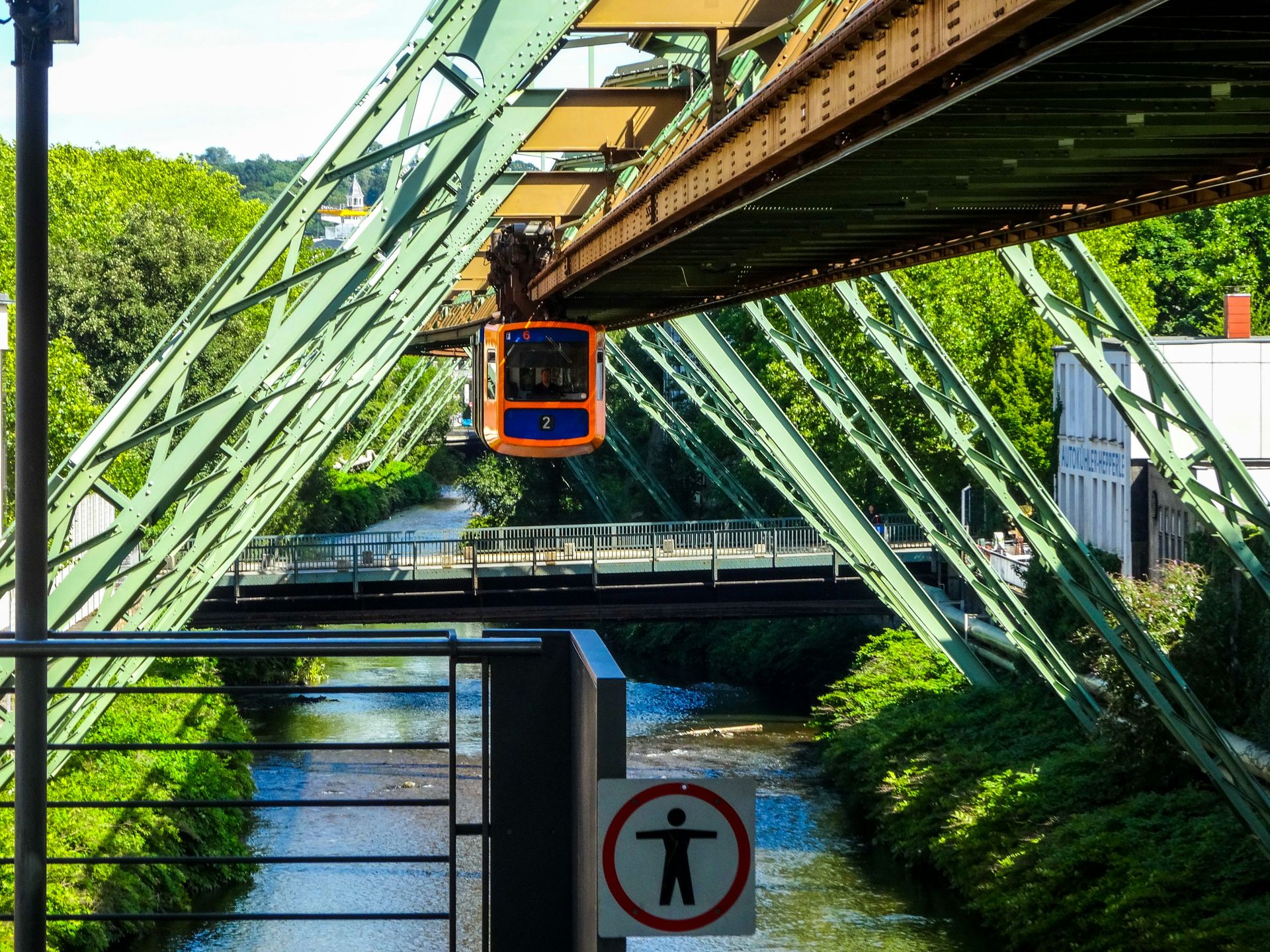
The Schwebebahn in Wuppertal, Germany, is a railway flipped upside down. Its trains hang beneath a steel track suspended above the Wupper River and the city's streets, and they have been doing so since 1901, which makes this the oldest suspended monorail in the world still in daily public service.
The design solved a specific local problem. Wuppertal grew as a string of industrial towns packed into a narrow river valley, leaving no room at street level for a conventional railway or tramway. Engineer Eugen Langen's solution was to build over the river itself: a lattice of steel supports straddling the Wupper for most of the line's 13.3-kilometer length, with trains swinging gently beneath.
The system is genuine transit, not a heritage ride. It carries tens of thousands of passengers on a normal weekday across 20 stations, running every few minutes, and a standard city transit ticket covers the full route. That ordinariness is part of the appeal for visitors: commuters read their phones while the carriage sways above the river, treating a structure from 1901 as unremarkable.
The line's most famous passenger was an elephant. In 1950, a circus promoting its show loaded a young elephant named Tuffi onto a carriage; she panicked, broke through the side and fell into the Wupper, landing in shallow water and surviving with minor scrapes. The incident became local legend, and Tuffi's image still appears around the city.
Riding end to end takes about half an hour and works as a moving city tour, passing the historic Kaiserwagen-era stations, factory buildings from the valley's textile past and the Wuppertal Zoo. The operator has periodically run the restored imperial carriage that Kaiser Wilhelm II rode during a 1900 test trip, a rolling museum piece on active track. A fleet of new articulated trains replaced the older cars in recent years, though the gentle swaying ride beneath the girders feels much as it long has.
Credit: Beyond My Ken / Wikimedia Commons (CC BY-SA 4.0)
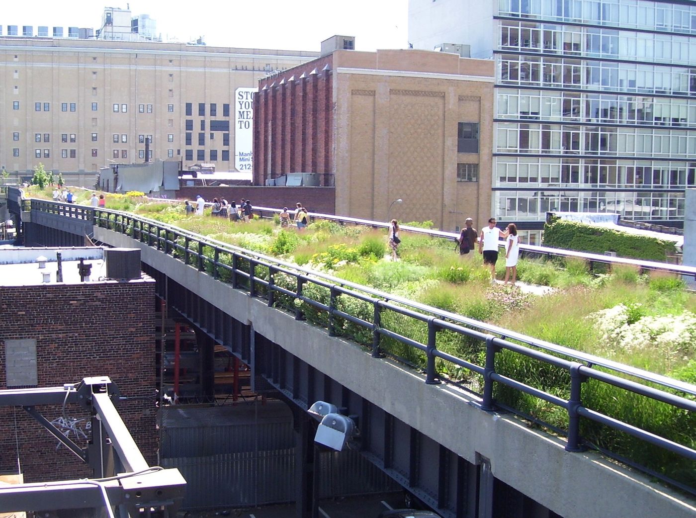
The High Line is what happens when a city decides not to demolish its obsolete infrastructure. The elevated steel rail line running up Manhattan's far west side was built in the early 1930s to lift freight trains off the streets, where they had killed so many pedestrians that 10th Avenue earned the nickname Death Avenue. Trains delivered meat, produce and mail directly into upper-story loading docks of warehouses along the route.
The last train ran in 1980, and the structure sat rusting for two decades while property owners lobbied for demolition. A neighborhood group called Friends of the High Line, founded in 1999, pushed the opposite idea: convert the viaduct into an elevated park. Photographs of the wild grasses and trees that had seeded themselves in the gravel ballast helped make the case.
The park opened in stages beginning in 2009 and now runs about 1.45 miles from Gansevoort Street in the Meatpacking District to 34th Street near Hudson Yards. The design, by James Corner Field Operations and Diller Scofidio + Renfro with planting by Piet Oudolf, deliberately preserves the infrastructure's identity. Rails remain embedded in the walkways, planting beds mimic the self-seeded landscape that grew during abandonment, and the path threads directly through buildings that once received freight.
Walking the route delivers a cross-section of the city at third-story height: views down the avenues, close passes by architecture old and new, an amphitheater window overlooking 10th Avenue traffic and the ecosystem of galleries and development that followed the park's success.
That success became its own global export. Cities from Seoul to Sydney have converted rail lines, flyovers and viaducts into linear parks citing the High Line as the model, making this stretch of 1930s freight infrastructure one of the most imitated public spaces of the 21st century. Entry is free, with stairway and elevator access points spaced along the route, and early mornings offer the emptiest walkways.
Credit: ignis / Wikimedia Commons (CC BY-SA 3.0)
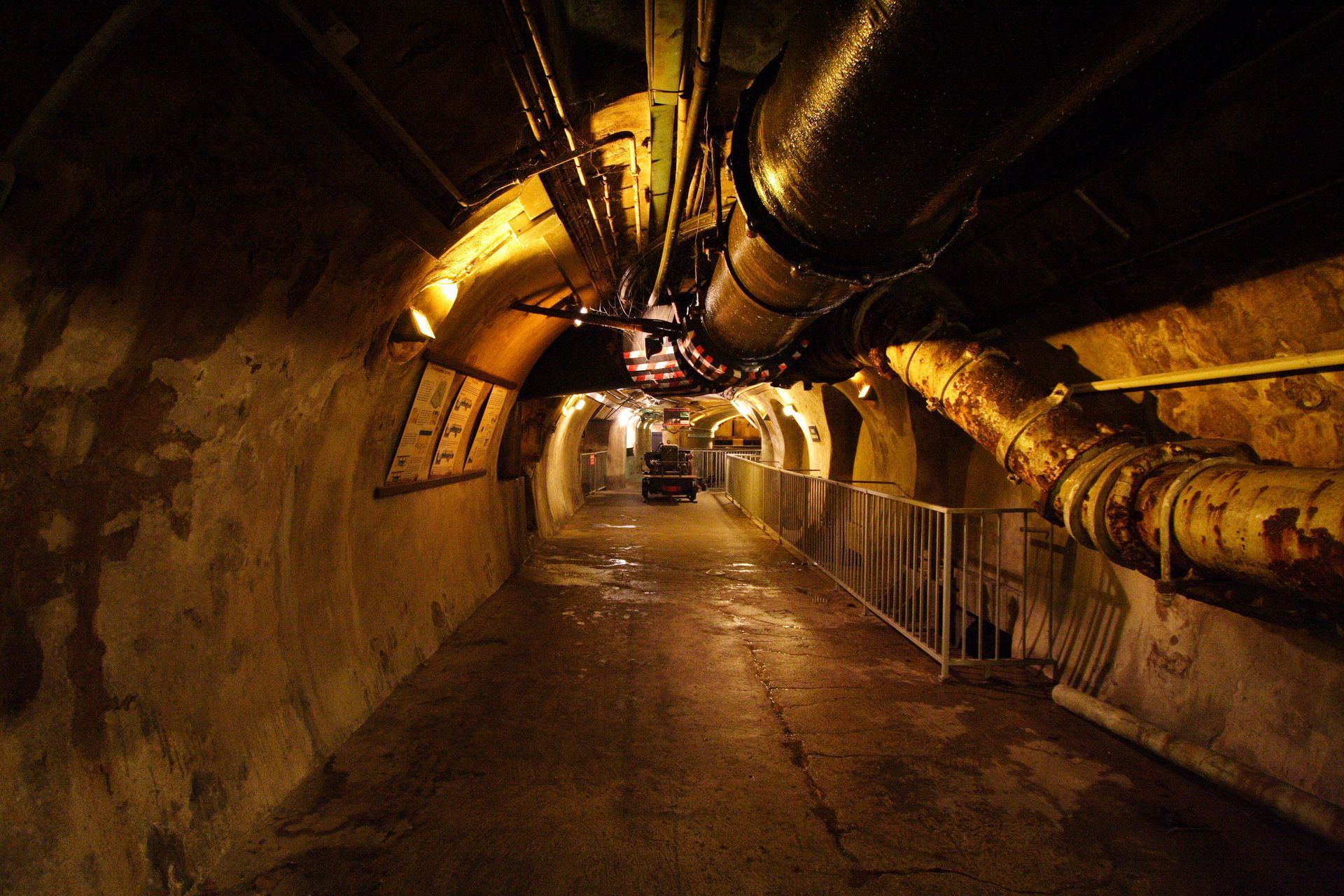
Paris built a monument underground and then decided to show it off. The Musée des Égouts de Paris — the Paris sewer museum — occupies a working section of the city's sewer network beneath the Left Bank near the Pont de l'Alma, and it continues a tradition of public sewer visits that began in Napoleon III's era, when tours were conducted by boat and later by wagon along the channels.
The network itself dates largely to the 1850s and 1860s, when engineer Eugène Belgrand, working under Baron Haussmann's reconstruction of Paris, designed a sewer system scaled far beyond the city's needs at the time. The galleries were built tall enough to walk through and wide enough to service, and they follow the streets above so faithfully that each tunnel carries a plaque with the name of the avenue overhead — an inverted map of the city.
The museum reopened in 2021 after a multiyear renovation. Visitors descend into genuine working galleries, complete with the sound and smell of flowing wastewater, and walk past the equipment the city has used to keep the channels clear, including the large wooden and iron cleaning balls once rolled through the tunnels to push sediment ahead of them.
Exhibits trace the history of Paris water from medieval filth through cholera outbreaks to the modern network, which spans more than 2,000 kilometers of tunnels. The sewers also carry the city's other utilities, and the practice of routing pipes and cables through the galleries means the network still earns its keep beyond drainage.
Literature gave the sewers their fame before tourism did. Victor Hugo devoted chapters of Les Misérables to the network, drawing on information from an inspector he knew, and the museum leans on that legacy — Jean Valjean's fictional escape route is now a ticketed attraction.
Credit:Mike M / Pexels
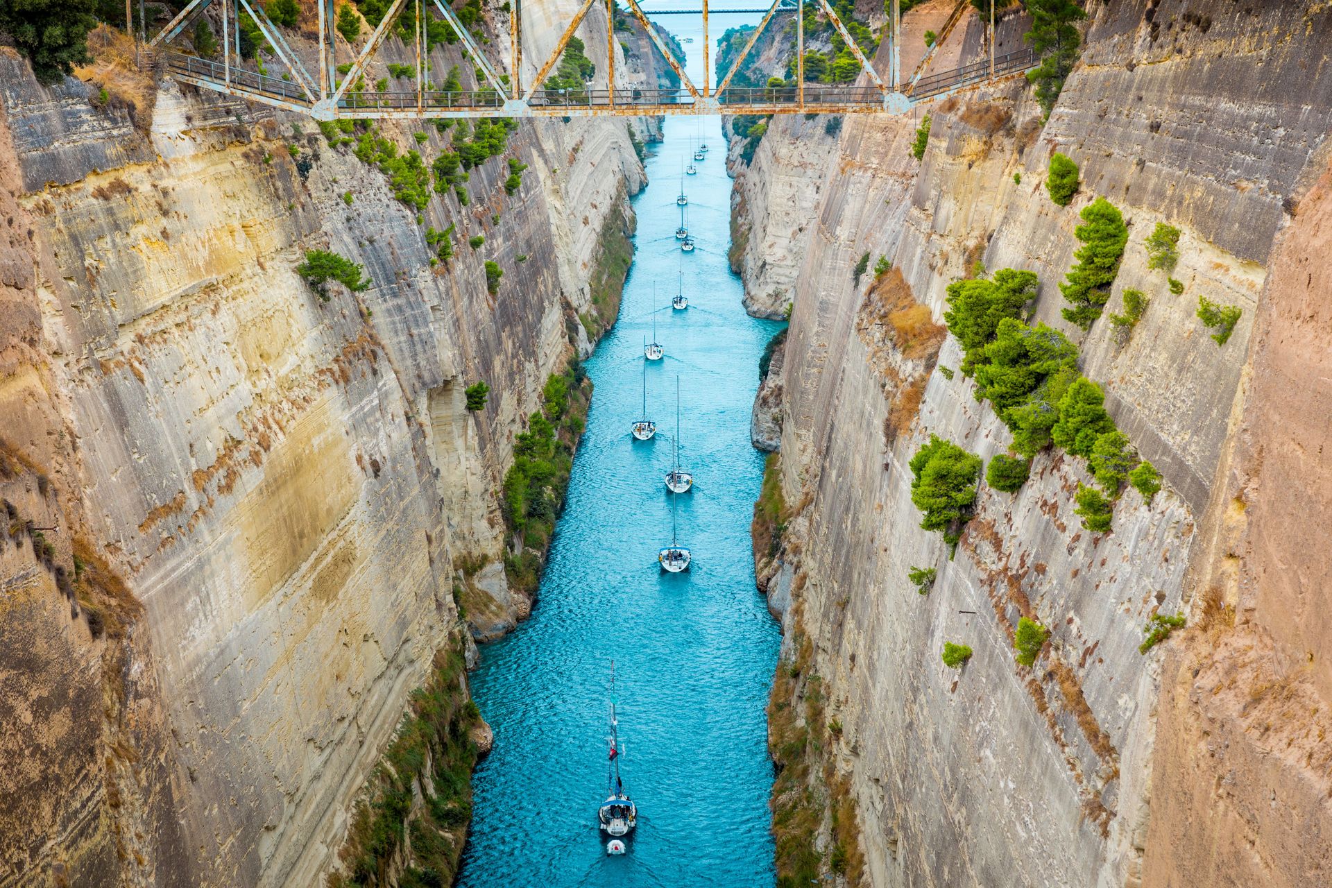
The Corinth Canal slices through the narrow isthmus connecting mainland Greece to the Peloponnese, and it looks less like a waterway than a wound: a dead-straight channel 6.4 kilometers long, cut through solid rock, with sheer walls rising as much as about 90 meters above the water. Seen from the road bridges that cross it, the canal is a thin ribbon of sea at the bottom of a man-made gorge.
The idea is ancient. Rulers proposed cutting the isthmus for centuries, and the Roman emperor Nero formally began the project in 67 AD, reportedly breaking ground himself with a golden pickaxe before the work was abandoned. Until the modern canal opened in 1893, ships either sailed the long way around the Peloponnese or, in antiquity, were hauled overland on a paved trackway called the Diolkos, traces of which survive near the canal's western end.
The finished canal arrived too late for its own purpose. At about 21.4 meters wide at sea level, it cannot admit modern cargo vessels, and its steep walls shed rock, forcing periodic closures for repairs. Commercial traffic is light. What remains is a spectacle: small ships, yachts and cruise vessels squeezing through a channel with almost no margin, sometimes under tow, while spectators watch from the bridges above.
The canal's obsolescence created its second career. A bungee jumping platform operates from a bridge over the channel, sending jumpers toward the water between the rock walls. Boat trips run transits for tourists. At each end, submersible bridges sink below the surface to let vessels pass — an oddity worth watching in itself.
The site rewards a short detour from Athens, about an hour away, and pairs with ancient Corinth nearby, letting visitors see the trade geography that made cutting the isthmus worth 2,000 years of trying. The central road bridge offers the classic straight-down view along the cut, with the rock walls catching low sun at either end of the day.
Credit: Martyn Sanders / Pexels
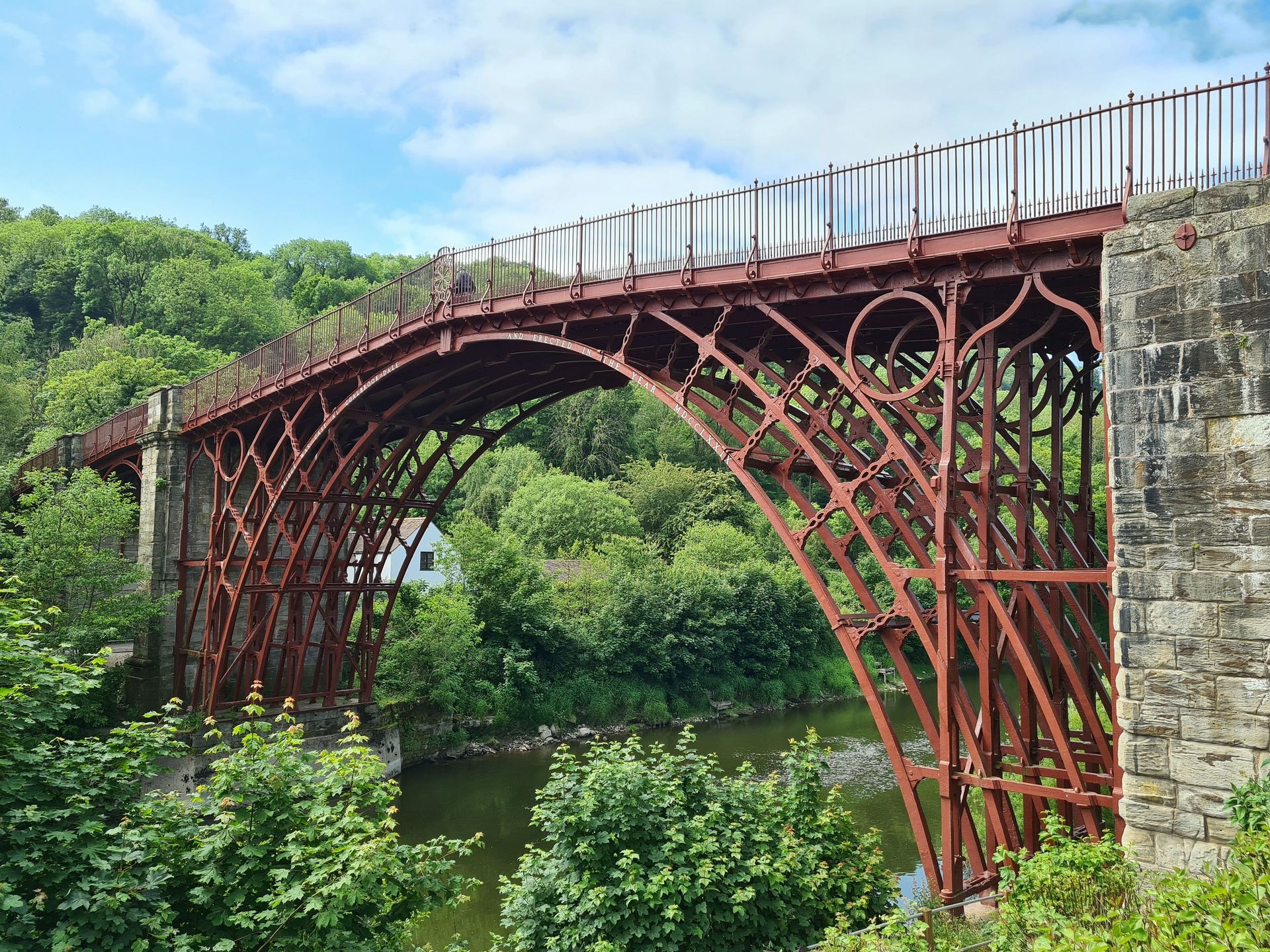
The Iron Bridge crosses the River Severn in Shropshire, England, and it announces its significance in its name: completed in 1779 and opened to traffic in 1781, it was the first major bridge in the world built of cast iron, and it gave its name to the settlement of Ironbridge and the gorge around it.
The location was not incidental. The Severn Gorge sat at the center of Britain's early Industrial Revolution. Nearby Coalbrookdale is where Abraham Darby I first smelted iron with coke instead of charcoal in 1709, a process change that made iron cheap and abundant enough to become a structural material. Seven decades later, his grandson Abraham Darby III cast the ribs for a single-span bridge of about 30 meters, assembled over the river using joints borrowed from carpentry — dovetails and wedges — because no one had yet worked out how to engineer connections for iron.
The bridge proved the material. Cast iron and then wrought iron and steel went on to reshape construction worldwide, and the span over the Severn stands as the demonstration piece. UNESCO listed the Ironbridge Gorge in 1986 as one of its first World Heritage Sites in the U.K., citing the area's role as a birthplace of industrialization.
The bridge closed to vehicles in the 1930s but remains open to pedestrians, and a major conservation project completed in 2018 repaired the ironwork and returned the structure to a red-brown color based on evidence of its original paint.
The surrounding gorge functions as a distributed museum. The Ironbridge Gorge Museums span multiple sites, including the original Coalbrookdale furnace, a recreated Victorian town at Blists Hill and museums of tile and porcelain manufacture — the industrial ecosystem that made a bridge of iron thinkable in the first place. Walking across the span costs nothing, and the tollhouse at one end, which still displays its original table of charges, now serves as an information point.
Credit: Alexander Sinn / Unsplash
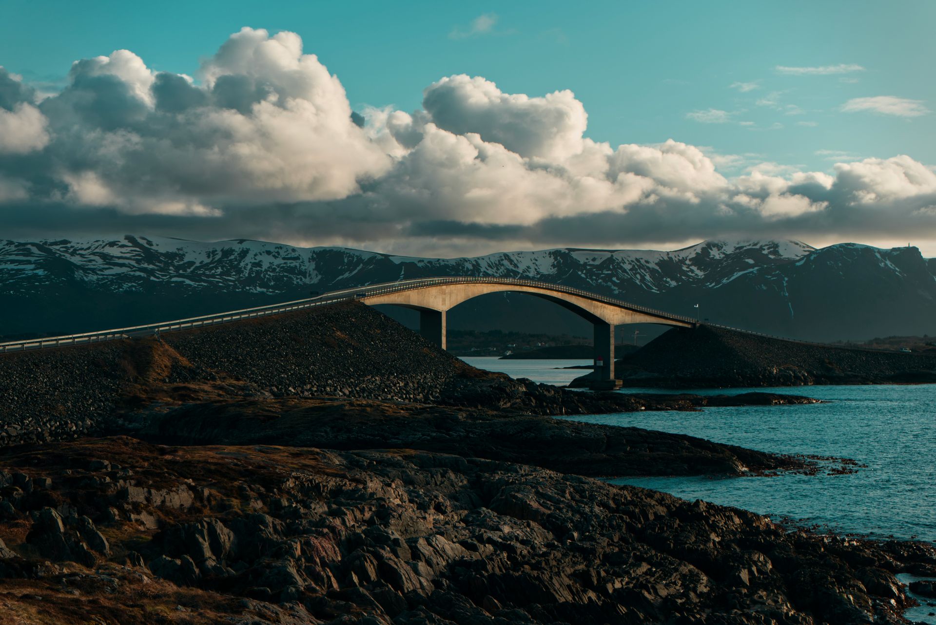
The Atlanterhavsveien, or Atlantic Ocean Road, connects a chain of small islands and skerries on Norway's west coast, and it does so with a flourish: eight bridges over 8.3 kilometers of causeways and spans, threading between the open Norwegian Sea on one side and fjord-sheltered water on the other.
The route opened in 1989 after a construction period battered by a dozen hurricane-force storms, replacing a ferry connection between the towns of Kristiansund and Molde. It began as ordinary regional infrastructure — a way for coastal communities to reach each other in any weather — and became famous because of how it looks and where it sits.
The signature structure is the Storseisundet Bridge, a cantilevered span whose sharp curve and steep rise produce a well-known optical illusion. Approached from certain angles, the road appears to bend upward and end in midair, a ramp launching cars into the sea. Cross the crest and the descent reveals itself. The image circulates widely online, usually framed as the world's strangest-looking bridge, and it functions as the road's unofficial logo.
Norway designated the road a National Tourist Route, one of a set of scenic drives the country has deliberately upgraded with architect-designed rest stops, walkways and viewpoints. Along the Atlantic Road, paths lead out onto the skerries, and a glass-walled viewpoint at Askevågen looks back along the bridges.
Conditions change the experience completely. On calm summer days, the drive takes minutes and feels gentle; anglers fish from the causeways, and the midnight sun stretches the sightseeing hours. In autumn storms, waves break over the roadway itself, and storm-watching from safe vantage points has become its own reason to visit — infrastructure and weather performing together. The full drive between Kristiansund and Molde takes well under an hour without stops, which makes the road an easy addition to a west-coast itinerary, and it links onward to other designated scenic routes for travelers continuing along the fjord country.