From ancient ruins to living ecosystems, these 25 UNESCO sites capture why the world's most significant places deserve protection — and a visit
Credit: Howard Walsh / Unsplash
The UNESCO World Heritage List now includes more than 1,100 sites across 167 countries, but the number obscures how selective the designation actually is. To earn it, a site must meet at least one of ten strict criteria — representing a masterpiece of human creative genius, bearing exceptional testimony to a civilization, containing superlative natural phenomena, or serving as a habitat for threatened species, among others. The nomination process takes years. Many candidates are rejected outright. The ones that make it carry a designation that comes with genuine weight.
The list spans the full range of what humanity and the natural world have produced: temples carved out of solid rock, rainforests older than most recorded history, industrial complexes that changed how the world worked, coral reefs that support a quarter of all marine life. What connects them is not simply age or beauty — though both are often present — but irreplaceability. These are places the world cannot afford to lose, for reasons that go beyond tourism or national pride.
That irreplaceability is increasingly under threat. Climate change has moved from being a distant risk for natural sites to an immediate one. The Great Barrier Reef has experienced mass bleaching events in consecutive years. Mountain glaciers catalogued by UNESCO are retreating. Flooding threatens Venice. Rising temperatures are drying out the Sahel landscapes around ancient cities in West Africa. In 2023, UNESCO added a formal "climate and World Heritage" reporting mechanism, requiring countries to assess climate risks to their inscribed sites.
The cultural sites face different but equally serious pressures. Mass tourism has strained infrastructure in Angkor, Machu Picchu, and the historic center of Prague. Urban development continues to encroach on buffer zones. Armed conflict has destroyed parts of sites in Syria and Mali that date back millennia. The inscription does not guarantee survival — it only names what is worth fighting to protect.
That is also what makes the list valuable as a framework. It forces a reckoning with what matters. Not every government agrees on all nominations; territorial disputes and historical grievances surface regularly in UNESCO debates. But the underlying principle — that certain places belong, in some meaningful sense, to all of humanity — is one worth taking seriously. The 25 sites below represent a cross-section of the list: some famous, some overlooked, all worth understanding on their own terms.
Credit: Daniel Pelaez Duque / Pexels
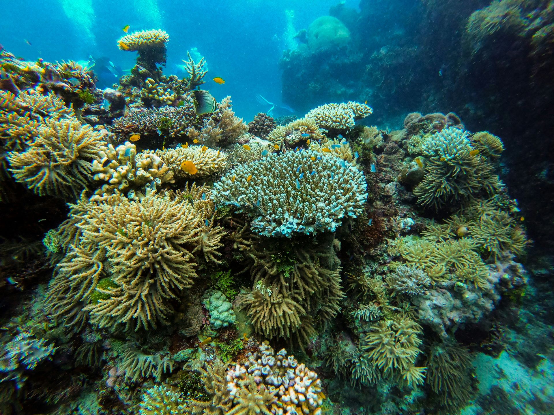
The Great Barrier Reef stretches more than 2,300 kilometers along the northeastern coast of Australia, making it the largest coral reef system on Earth. It was inscribed as a UNESCO World Heritage Site in 1981, recognized for its outstanding universal value across four of the natural criteria — a rare distinction. The reef contains roughly 3,000 individual reef systems and coral cays, alongside hundreds of tropical islands.
The scale is difficult to comprehend from the surface. The reef is larger than the United Kingdom, Switzerland, and the Netherlands combined. It is the only living structure on Earth visible from space. More than 1,500 species of fish live within the system, along with 4,000 types of mollusk, 240 species of bird, and six of the world's seven species of marine turtle.
What makes the reef exceptional from a scientific standpoint is its role as a barometer. Coral bleaching — the stress response that turns reef systems white and can lead to mass die-offs — occurs when water temperatures rise above the threshold corals can tolerate. The Great Barrier Reef has experienced bleaching events with increasing frequency and severity since the 1980s. Between 2016 and 2022, the reef experienced five mass bleaching events. The 2022 event was the first to occur during a La Niña cycle, which typically brings cooler temperatures, signaling that background ocean warming has shifted the baseline.
UNESCO has repeatedly considered placing the reef on its "in danger" list, a designation that carries formal international scrutiny and pressure on Australia to act. The Australian government has resisted the classification, arguing it has committed billions of dollars to reef protection through water quality programs, reduced agricultural runoff, and crown-of-thorns starfish control. Scientists remain divided on whether those interventions are commensurate with the scale of the threat.
For visitors, the experience of the reef — reached primarily through Cairns or the Whitsunday Islands — remains extraordinary. Snorkeling over a healthy section of coral, surrounded by parrotfish, reef sharks, and sea turtles, offers a direct encounter with a level of biodiversity that is genuinely rare. The urgency around the reef's future has, if anything, intensified the case for understanding what is at stake.
Credit: Serg Alesenko / Pexels
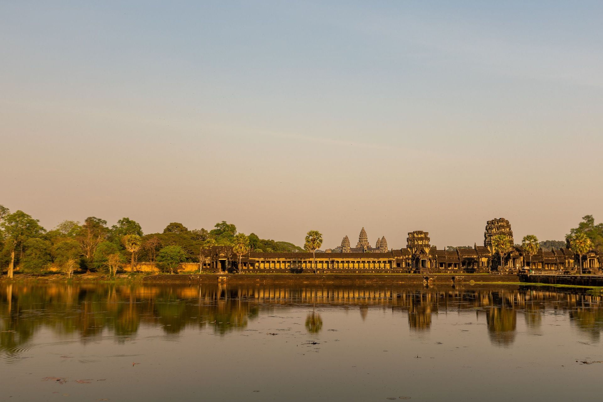
Angkor was the capital of the Khmer Empire from approximately the ninth through the 15th centuries, and it remains one of the most extensive pre-industrial urban complexes ever discovered. The UNESCO site covers roughly 400 square kilometers in the northwestern province of Siem Reap. At its height, Angkor may have housed as many as one million people — a population that would have made it the largest city in the world at the time.
The complex is built around a series of temples constructed by successive Khmer kings, each designed to be both a seat of royal power and a cosmological representation of the Hindu or Buddhist universe. Angkor Wat, the largest religious monument on Earth by land area, was built in the early 12th century by King Suryavarman II. It is oriented to the west, toward the setting sun — an alignment associated with death and the afterlife — and its central tower represents Mount Meru, the sacred mountain at the center of Hindu cosmology.
Angkor Thom, the last great capital of the Khmer Empire, was built by King Jayavarman VII in the late 12th century after a devastating Cham invasion. Its Bayon temple is notable for its 216 massive stone faces carved onto towers throughout the complex — one of the most recognizable images in Southeast Asian architecture. The faces are generally interpreted as representing either the king himself or the bodhisattva Avalokitesvara.
The site was largely abandoned after the 15th century and overgrown by jungle for centuries before French archaeologists began systematic work in the late 19th century. Much of what visitors see today reflects decades of restoration, with international teams continuing conservation work on specific structures.
The practical challenge of Angkor today is visitor volume. More than two million tourists arrived annually before the pandemic. The shale paths, wooden walkways, and underlying soil around temples have absorbed enormous traffic. The Cambodian government, working with UNESCO, has adjusted ticketing systems and access routes to distribute pressure across the site rather than concentrating it on Angkor Wat alone.
Credit: karen solorzano / Unsplash
Charles Darwin arrived at the Galápagos Islands in September 1835, spent five weeks there, and left with observations that would reshape how humanity understood the origins of species. The islands sit in the Pacific Ocean roughly 900 kilometers west of the Ecuadorian coast, and their isolation — combined with the influence of several intersecting ocean currents — produced an ecosystem found nowhere else on Earth.
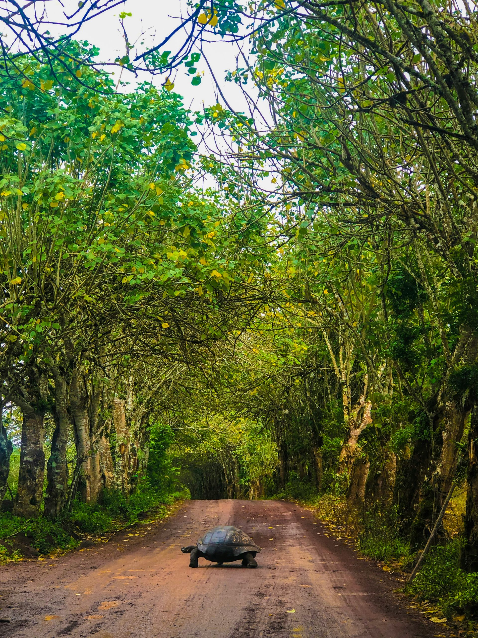
The Galápagos were the first site inscribed on the UNESCO World Heritage List, in 1978. The designation recognized both the extraordinary biodiversity of the archipelago and its role in the development of evolutionary science. The islands contain species that evolved in the absence of natural predators, producing animals with no instinctive fear of humans — a characteristic that continues to define the visitor experience. Marine iguanas, blue-footed boobies, and Galápagos giant tortoises can be observed from a few feet away without the animals showing alarm.
The giant tortoise is perhaps the most significant symbol of the islands. Different species evolved on different islands to exploit available food sources — dome-shaped shells for tortoises living on lush highlands, saddle-backed shells for those reaching up to dry-land cactus. Darwin did not initially recognize the significance of this variation during his visit; the insight developed later, through examination of specimens he brought back to London.
The islands were listed as "in danger" by UNESCO from 2007 to 2010, prompted by the rapid growth of the human population and associated infrastructure. The resident population had grown from a few hundred people in the early 20th century to more than 25,000, with corresponding increases in introduced species, tourism infrastructure, and fishing pressure. Ecuador responded with a series of reforms — stricter controls on immigration to the islands, expanded marine protected areas, and tighter regulation of tourism operations.
The islands remain fragile. Introduced species — rats, cats, and feral goats — continue to threaten native wildlife on some islands, and the Galápagos National Park Service conducts ongoing eradication programs.
Credit: Howard Walsh / Unsplash
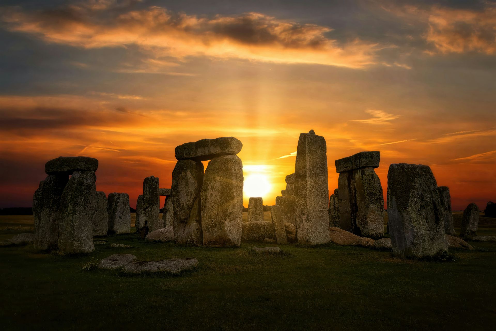
Stonehenge sits on the open chalk plain of Wiltshire in southern England, and the questions around it have not diminished with study. The monument as it stands today — a ring of massive standing stones, some weighing 25 tons, arranged with clear astronomical alignments — is the result of construction and modification over roughly 1,500 years, from approximately 3000 BCE to 1500 BCE. It was not built in a single phase, and its purpose was not fixed.
The larger UNESCO site encompasses Stonehenge alongside Avebury, a henge monument and stone circle roughly 30 kilometers to the north that is, by circumference, larger than Stonehenge itself. The Avebury henge contains two inner circles and was part of a wider ritual landscape that included the West Kennet long barrow — one of the largest Neolithic chambered tombs in Britain — and Silbury Hill, the largest prehistoric man-made mound in Europe.
The UNESCO inscription covers this entire Neolithic and Bronze Age ceremonial landscape rather than any single structure, which reflects how archaeologists now understand the period. These were not isolated monuments but interconnected sites within a landscape used for burial, gathering, and ritual over millennia.
The astronomical alignments at Stonehenge are real and precise. The axis of the monument aligns with the sunrise on the summer solstice and the sunset on the winter solstice. Whether this reflects a solar calendar, a ritual of death and rebirth, or some combination remains debated. The bluestones used in the inner ring were transported roughly 250 kilometers from the Preseli Hills in Wales — a logistical undertaking of the first order given the technology available at the time. How they were moved remains an active area of research.
The site draws over one million visitors per year. For most of the 20th century, visitors could walk freely among the stones. Access is now restricted to a path around the perimeter, with special access visits available for smaller groups at dawn or dusk.
Credit: Willian Justen de Vasconcellos / Pexels
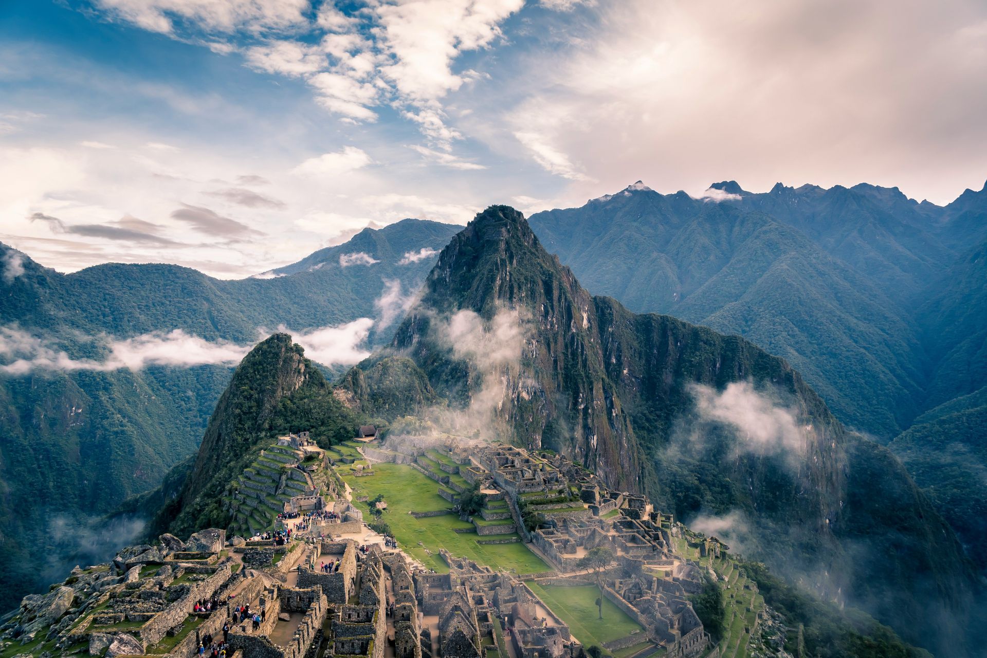
Machu Picchu was built in the mid-15th century at the order of the Inca emperor Pachacuti, constructed on a saddle ridge between two mountains at an elevation of roughly 2,430 meters above sea level in the Peruvian Andes. It was inhabited for fewer than 100 years before being abandoned — likely following the Spanish conquest of the Inca Empire — and remained largely unknown to the outside world until American historian Hiram Bingham III was guided to the site in 1911.
The site is simultaneously a feat of engineering and a demonstration of Inca mastery of their environment. The buildings were constructed using ashlar masonry — stones cut to fit together precisely without mortar — and the largest stones weigh more than 50 tons. The drainage system, designed to handle the roughly two meters of annual rainfall the site receives, remains largely functional. Terraced agricultural fields cut into the mountainside were used to grow crops in an environment where flat land was essentially nonexistent.
The purpose of Machu Picchu has been interpreted variously as a royal estate, a religious sanctuary, an astronomical observatory, and an administrative center. The evidence supports elements of all four interpretations. The Intihuatana stone, a carved ritual stone at the site, is aligned to point directly at the sun during the winter solstice. The Temple of the Three Windows frames the surrounding peaks in ways that suggest deliberate cosmological siting.
The UNESCO site covers 326 square kilometers and includes not just the citadel but the surrounding cloud forest, which is itself ecologically significant — part of a transition zone between Andean highlands and Amazonian lowland that contains exceptional biodiversity.
Visitor management has become critical. Peru has implemented a daily visitor cap and a timed entry system after years of overcrowding, with the citadel itself limited to around 4,000 visitors per day across staggered entry windows. The town of Aguas Calientes, at the base of the mountain, has grown into a full-scale tourist infrastructure hub.

Credit: Hugo Sykes / Pexels
The Serengeti ecosystem covers roughly 30,000 square kilometers of northern Tanzania and extends into Kenya's Masai Mara, forming the largest intact mammal migration system on Earth. The annual wildebeest migration — in which approximately 1.5 million wildebeest, along with hundreds of thousands of zebra and gazelle, move in a continuous loop following seasonal rains — is one of the most documented wildlife events in the world, but the numbers still require context to fully register.
The UNESCO inscription covers the Serengeti National Park itself, roughly 14,763 square kilometers, inscribed in 1981. The park forms the core of the broader ecosystem, which includes the Ngorongoro Conservation Area to the southeast and several game reserves and protected corridors.
The Serengeti's ecology is driven by grass. The short-grass plains of the southeast, which receive less rainfall, sustain the wildebeest calving season from roughly January to March. As those grasses dry out, the herds move northwest and north toward the Mara River and Kenya, where rainfall arrives later in the year. The Mara River crossings — moments when columns of wildebeest plunge into crocodile-filled water to reach the northern grasslands — have become iconic in wildlife photography and film.
The park contains the highest density of large predators on Earth. Lions, leopards, cheetahs, African wild dogs, spotted hyenas, and both black and white rhinos (the latter now critically endangered) share the ecosystem with their prey. The park's carrying capacity for wildlife has historically been high because the prey base itself is enormous.
Threats to the Serengeti ecosystem include human settlement pressure along migration corridors outside the park boundaries, poaching, and proposals — now suspended — for a highway that would have cut across the northern section of the park and bisected the migration route. The road proposal generated significant international scientific opposition and illustrated how infrastructure decisions inside and outside protected areas interact.
Credit: Josh Stewart / Unsplash
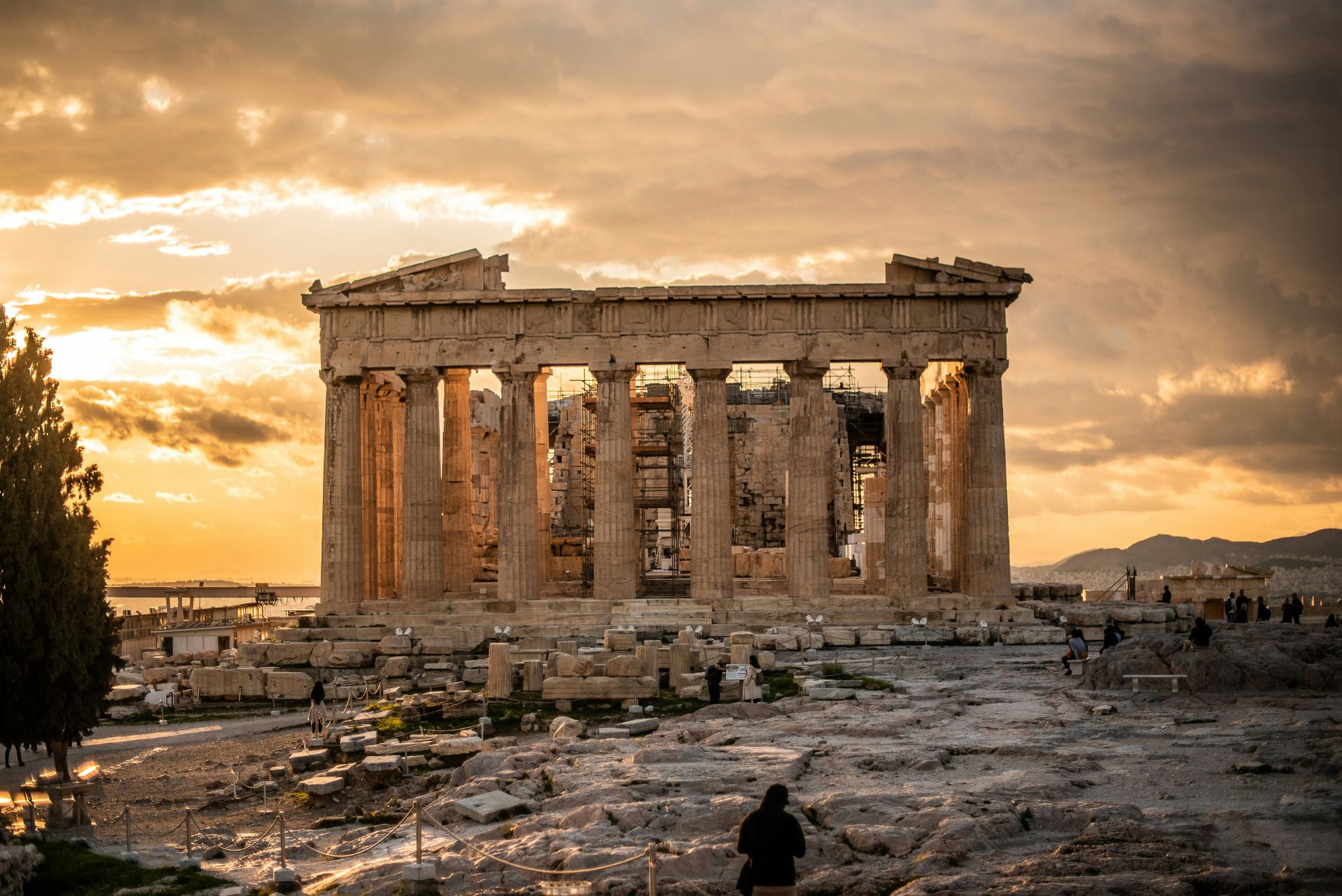
The Acropolis of Athens sits on a flat-topped limestone hill roughly 150 meters above the surrounding city, and it has been in continuous use — as a settlement, fortress, religious center, and cultural landmark — for approximately 5,000 years. The UNESCO inscription from 1987 covers the Acropolis itself along with several nearby ancient sites.
The structures that define the Acropolis were largely built during a single extraordinary period: the second half of the fifth century BCE, under the political leadership of Pericles and the architectural direction of the sculptor Phidias. The Parthenon, a temple dedicated to Athena, was completed in 432 BCE. The Erechtheion, with its Porch of the Caryatids — columns carved in the form of female figures — was finished around 406 BCE. The Propylaia, the monumental gateway to the Acropolis, was begun in 437 BCE but left incomplete due to the outbreak of the Peloponnesian War.
What makes the Athenian architectural achievement distinctive is not simply its scale but its precision. The Parthenon's columns are not perfectly vertical — they lean slightly inward — and the horizontal surfaces of the stylobate curve upward slightly toward the center. These are deliberate optical corrections intended to prevent the structures from appearing to sag or lean when viewed at a distance. The degree of geometric sophistication required to execute these corrections in stone remains a subject of architectural study.
The Parthenon's sculptures — the Elgin Marbles, now split between the Acropolis Museum in Athens and the British Museum in London — represent the most contentious ongoing cultural property dispute in the world. Greece has requested their return for decades. The British Museum's position, rooted in arguments about universal access and legal ownership, has not fundamentally shifted, though the debate has intensified in recent years.
The Acropolis Museum, opened in 2009 at the base of the hill, was designed specifically to house the surviving sculptures and present them in context with the monuments they came from. It deliberately left space for the return of the British Museum's holdings.
Credit: AXP Photography / Pexels
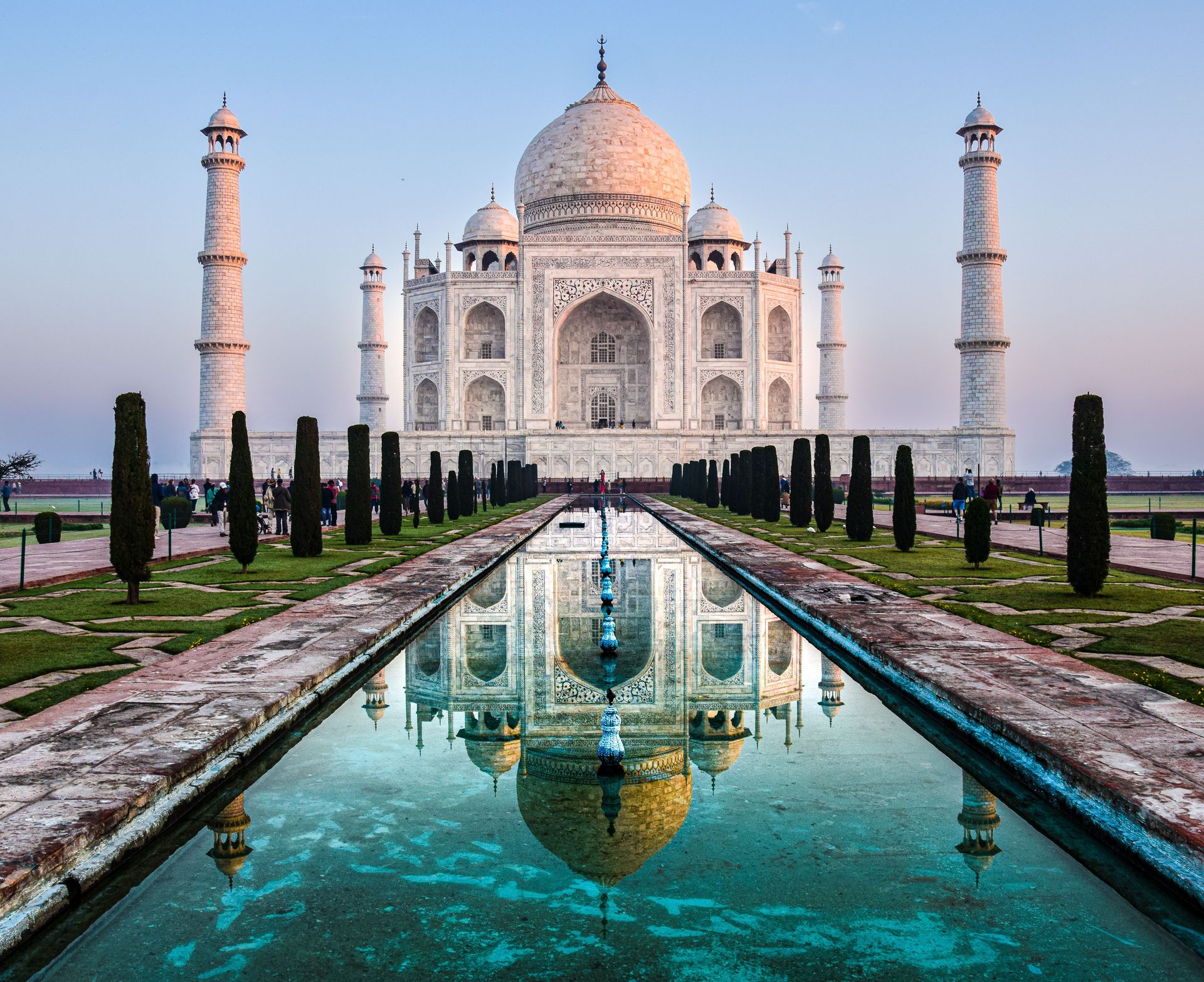
The Taj Mahal was built between 1632 and 1653 by the Mughal emperor Shah Jahan as a mausoleum for his wife Mumtaz Mahal, who died during the birth of their 14th child. It stands on the southern bank of the Yamuna River in Agra, Uttar Pradesh, and is constructed primarily of white Makrana marble inlaid with semi-precious stones — carnelian, lapis lazuli, jade, crystal, and turquoise — in a technique known as pietra dura.
The site covers roughly 17 hectares and is organized around principles of Mughal garden design: a long central water channel flanked by cypress trees, with the mausoleum positioned at the northern end of a walled complex rather than at the center as is more common. The positioning — with the river behind the mausoleum and open sky as a backdrop — was deliberate. The complex also includes a mosque to the west and a identical "guest house" to the east, built as a mirror image purely for visual symmetry since it faces the wrong direction for Islamic prayer.
The optical quality of the Taj Mahal shifts dramatically with light conditions. At dawn, the marble appears pink. In midday sun, it reads as bright white. In full moonlight, it takes on a bluish cast. These variations are not incidental — the choice of Makrana marble, noted for its reflective translucency, was made with full awareness of how the material responds to light.
The structure has faced air quality threats for decades. Sulfur dioxide emissions from factories in the Agra region have contributed to a yellowing of the marble surface, a problem that has prompted court-ordered industrial restrictions. The Archaeological Survey of India applies a traditional mud-paste treatment called multani mitti to the surface periodically to draw out pollutants and restore the marble's color.
With approximately eight million visitors annually, the Taj Mahal is one of the most visited sites on the UNESCO list. Entry is managed through ticket quotas, and the site closes on Fridays.
Credit: Canva Images
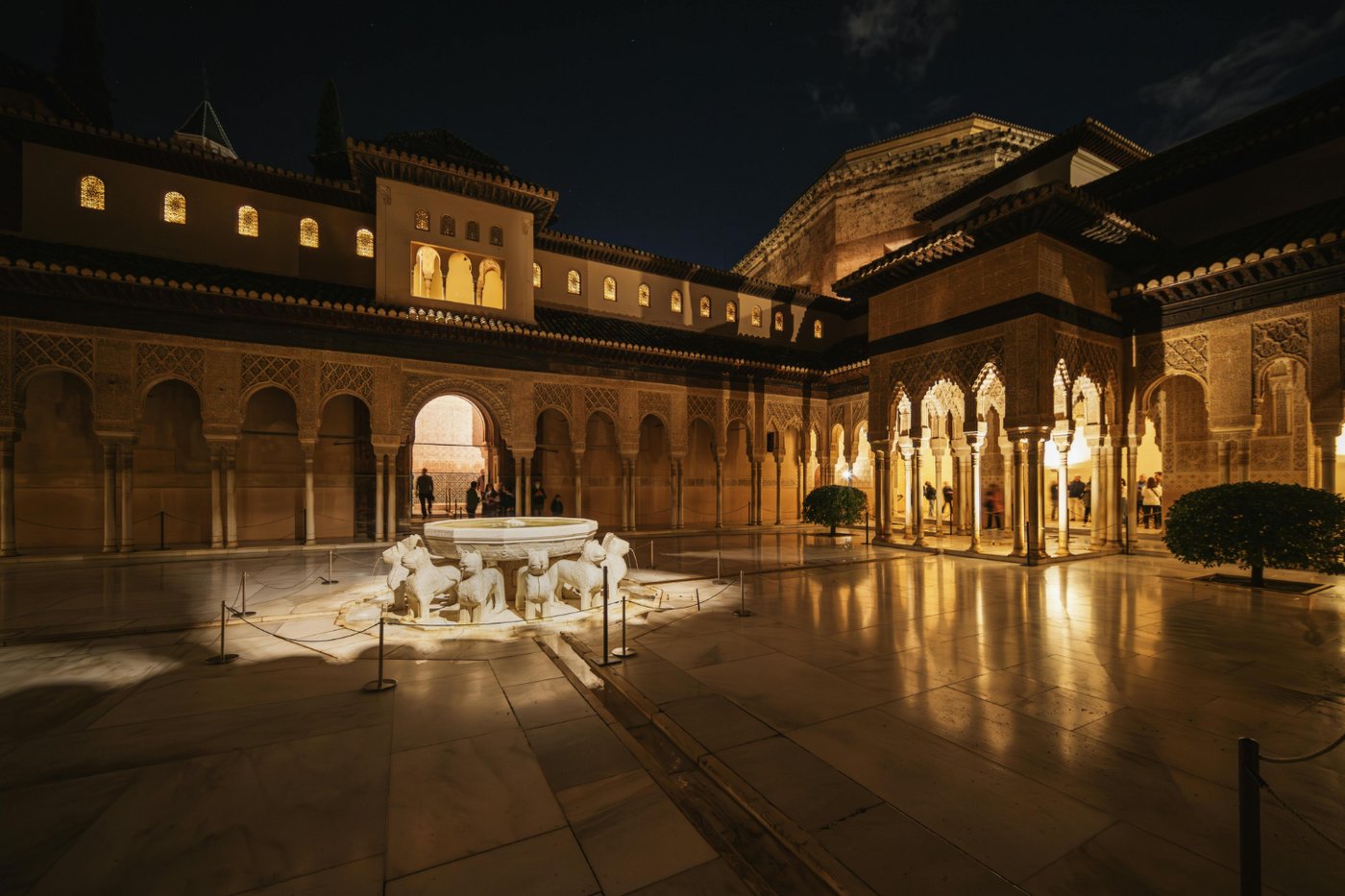
The Alhambra occupies a plateau above the city of Granada in southern Spain, overlooking the Sierra Nevada. It was constructed primarily between the 13th and 14th centuries as a palace and fortress complex for the Nasrid dynasty, the last Islamic rulers of the Iberian Peninsula. The Nasrid Kingdom of Granada was the final holdout of Al-Andalus — the Muslim-ruled territories that had once covered most of the Iberian Peninsula — and it fell to Ferdinand and Isabella in January 1492.
The Alhambra's architecture is defined by interior complexity rather than exterior grandeur. From the outside, the complex reads as a series of red-brown towers and walls. Inside, the palaces — particularly the Comares Palace and the Palace of the Lions — are covered with intricate stucco carving, tile work, and wooden muqarnas ceilings of extraordinary geometric sophistication. The Court of the Lions, built under Muhammad V in the late 14th century, is organized around a central fountain supported by 12 marble lions. The surrounding arcade features more than 100 slender marble columns, each one unique.
Water is fundamental to the Alhambra's design. The complex was built around an elaborate hydraulic system that channeled water from the Sierra Nevada through the palaces and gardens, creating pools, fountains, and the sound of running water throughout. In a climate where summers are extremely hot, this was both a practical comfort and a symbol of power.
The Generalife, inscribed alongside the Alhambra, is the summer palace and gardens above the main complex. The Albayzín, the old Moorish quarter below the Alhambra on the opposite hill, was added to the inscription in 1994 as a living urban landscape that preserves elements of medieval Islamic city planning.
The Alhambra is the most visited monument in Spain, receiving more than 2.5 million visitors per year. Timed entry has been in place for years, with admission to the Nasrid Palaces — the most visited section — strictly limited to 300 people per 30-minute window.
Credit: James Lee / Pexels
Yellowstone became the world's first national park in 1872, and it was among the first natural sites inscribed on the UNESCO World Heritage List, in 1978. It sits in the northwestern corner of Wyoming, with small portions extending into Montana and Idaho, and it represents one of the most geologically active places on Earth's surface.
The park sits above a supervolcano — a term referring to a volcanic system capable of producing eruptions of exceptional scale. The Yellowstone caldera, roughly 55 kilometers across, formed during an eruption approximately 640,000 years ago. The geological heat below the surface drives the hydrothermal features that define the park: more than 10,000 geothermal features, including roughly 500 geysers — the largest concentration in the world.
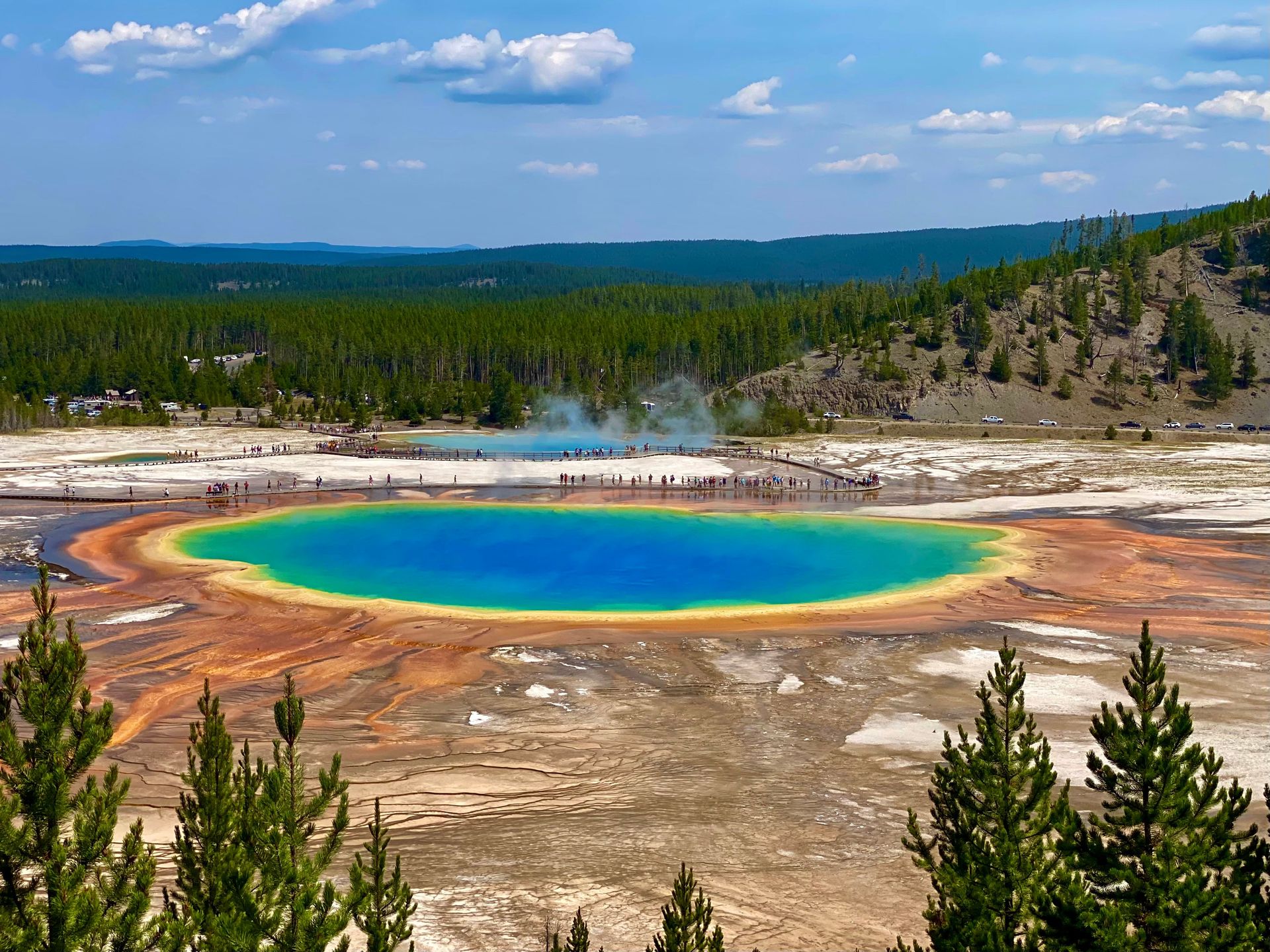
Old Faithful, the most famous geyser, erupts roughly every 90 minutes, sending a column of steam and water between 30 and 55 meters into the air. The interval has lengthened slightly since the 1959 Hebgen Lake earthquake, which disrupted the underground plumbing systems. Grand Prismatic Spring, with a diameter of roughly 90 meters, is the largest hot spring in the U.S. and the third largest in the world. Its vivid rings of color — deep blue at the center, surrounded by rings of green, yellow, and orange — result from heat-adapted microbial mats growing at different temperature gradients.
Yellowstone was also the site of a landmark wolf reintroduction. Gray wolves were hunted to local extinction by the 1920s. Their reintroduction in 1995 and 1996, bringing 41 wolves from Canada, triggered changes that cascaded through the ecosystem. As wolf predation altered elk grazing behavior, riverbank vegetation recovered, stream channels stabilized, and bird and beaver populations responded in kind — an ecological phenomenon widely used to illustrate trophic cascades.
The park receives roughly four million visitors per year, primarily between June and September. Infrastructure expansion and the growth of gateway communities have increased pressure on the park's edges, while climate change is affecting the timing and magnitude of snow cover, which drives downstream water availability throughout the region.
Credit: Spencer Davis / Unsplash
Rome's historic center holds a density of significant monuments — imperial fora, temples, churches, palazzos, medieval streets, and Renaissance piazzas — that is unmatched among European capitals. The UNESCO inscription, formalized in 1980 and extended to include properties of the Holy See in 1984, covers the historic urban area along with Vatican City and the Basilica of Saint Paul Outside the Walls.
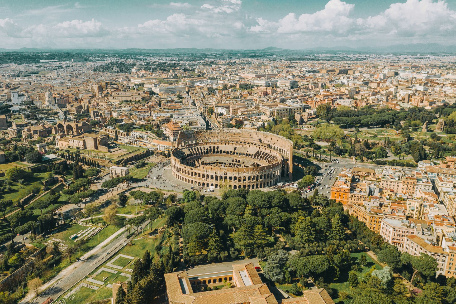
The city has been continuously occupied for approximately 2,800 years, and the layering of historical periods is physically visible in its urban fabric. Republican-era temples from the second and third centuries BCE stand adjacent to medieval churches built directly into their walls. The Pantheon, completed around 125 CE under the Emperor Hadrian, has the best-preserved ancient Roman concrete dome in the world — its central oculus, nine meters in diameter, remains the only source of light in the interior. The Colosseum, built between 70 and 80 CE, could hold between 50,000 and 80,000 spectators and staged gladiatorial contests and public executions for centuries.
Vatican City, with an area of roughly 44 hectares, is the smallest internationally recognized state in the world. Saint Peter's Basilica, the result of more than a century of construction from 1506 to 1626 and involving architects including Bramante, Raphael, Michelangelo, and Bernini, is the largest church in the world by interior volume. Michelangelo's dome, completed after his death according to his design, reaches a height of roughly 136 meters from the floor to the top of the lantern.
The challenge for Rome's historic center is not preservation of individual monuments — the Italian state and the Vatican invest substantially in maintenance and restoration — but the management of an inhabited city around its heritage fabric. Rome has 2.8 million residents. Its ancient infrastructure, including roads, piazzas, and underground structures, is in constant tension with the demands of modern urban life.
Credit: Yasir Gürbüz / Pexels
Petra was the capital of the Nabataean Kingdom from roughly the fourth century BCE until the Romans annexed it in 106 CE. The Nabataeans were a trading people who controlled the overland spice and incense routes connecting the Arabian Peninsula to the Mediterranean, and Petra — built in a sandstone canyon in what is now southern Jordan — served as both their administrative center and a demonstration of their wealth.
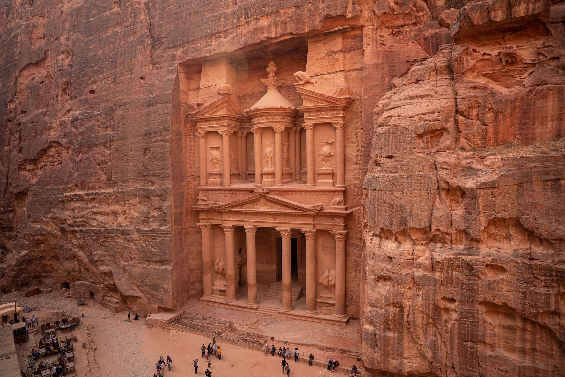
The defining feature of Petra is not free-standing construction but rock-cut architecture: temples, tombs, and dwellings carved directly into the rose-red sandstone cliffs of the Wadi Rum region. The façades are often elaborate — columns, pediments, and sculptural detail executed in stone that ranges from pale cream to deep crimson depending on the mineral content and the angle of light. The Treasury (Al-Khazneh), carved in the first century BCE, is the most photographed structure, its upper tier decorated with figures from both Nabataean and Hellenistic religious traditions.
The Nabataeans also engineered an extensive water system — dams, cisterns, channels, and pipes — that collected and stored rainwater in an otherwise arid landscape. This hydraulic infrastructure is what made sustained urban habitation possible in a desert canyon. At its height, Petra may have had a population of roughly 20,000.
Petra was lost to Western awareness for centuries after the decline of the trade routes that sustained it. The Swiss explorer Johann Ludwig Burckhardt reached the site in 1812, disguised as an Arab traveler, and became the first modern Westerner to report its existence.
The site, inscribed in 1985, covers roughly 264 square kilometers. The main archaeological zone is accessible through the Siq — a narrow, winding canyon about 1.2 kilometers long whose walls rise up to 80 meters — which dramatically reveals the Treasury at its end. About 1,000 Bedouin families from the Bdoul tribe were resettled outside the site during the 1980s when it was formally established as a national park, a displacement that remains a sensitive political issue.
Credit: Bruna Santos / Pexels
Kyoto served as Japan's imperial capital for more than a millennium, from 794 CE until the court transferred to Tokyo in 1869. The city's role as a political and cultural center produced an extraordinary concentration of temples, shrines, palaces, and gardens. The UNESCO inscription, established in 1994, covers 17 specific properties across Kyoto, Uji, and Otsu rather than the entire city — a structure that reflects how Japanese heritage protection has historically worked around the demands of a living urban environment.
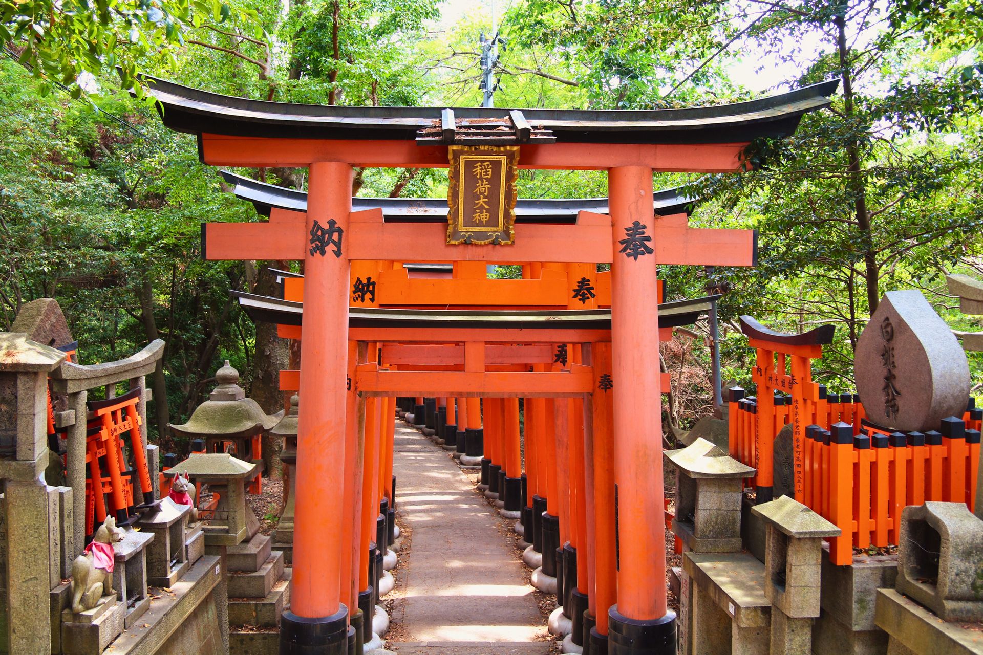
The inscribed properties span the full range of Japanese religious and court architecture across more than 1,000 years. Kinkaku-ji (the Golden Pavilion), originally built in 1397 as the retirement villa of the shogun Ashikaga Yoshimitsu, sits at the edge of a reflective pond surrounded by carefully composed gardens. The current structure dates to 1955, rebuilt after a monk burned the original in 1950 — an event later fictionalized in Yukio Mishima's novel "The Temple of the Golden Pavilion." Fushimi Inari-Taisha, a Shinto shrine dating to 711 CE, is known for the thousands of vermilion torii gates that line its mountain paths.
Nijo Castle, built in 1603 as the Kyoto residence of the Tokugawa shogunate, contains "nightingale floors" — corridors designed to squeak when walked upon as a security measure against intruders. The technique involves a system of nails and clamps beneath the floorboards that create a high-pitched sound under the weight of a footstep.
Ryoan-ji contains what is widely considered the most celebrated dry landscape garden (karesansui) in Japan: 15 stones of different sizes arranged in white gravel, positioned so that no matter where a viewer stands, 14 stones are visible but one is always hidden. The garden dates to the late 15th century; its authorship is unknown.
Kyoto attracts roughly 50 million visitors per year, including day-trippers from Tokyo and Osaka. The density of tourism in specific neighborhoods — particularly Higashiyama and Arashiyama — has prompted the city to introduce access restrictions and visitor fees in certain streets.
Credit: Bernd 📷 Dittrich / Unsplash
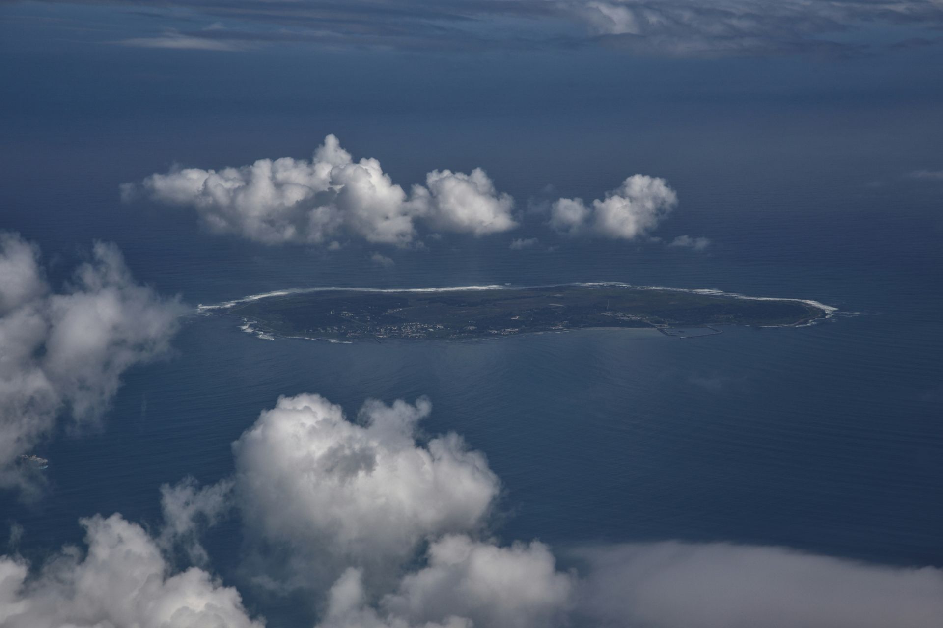
Robben Island sits in Table Bay, roughly 11 kilometers from the Cape Town waterfront, and its history as a place of confinement and exile spans several centuries. The Dutch East India Company used it as a place of banishment in the 17th century. During the British colonial period it served as a leper colony and asylum. Under the apartheid government it became South Africa's most significant political prison, holding Nelson Mandela from 1964 to 1982 along with hundreds of other anti-apartheid activists.
The UNESCO inscription from 1999 recognized Robben Island as a symbol of the triumph of democracy and freedom over oppression — the site's heritage value is explicitly tied to its political meaning rather than architectural or natural significance. This makes it one of the most distinctive entries on the World Heritage List: a place of deliberate suffering whose value lies in what it represents about human resistance and political change.
Mandela's cell in Section B — a small, damp room measuring roughly four square meters, where he slept on a mat on the floor and was initially forbidden from wearing long trousers or receiving newspapers — is open to visitors. The tours are conducted by former political prisoners, many of whom were themselves held at Robben Island. This is a deliberate pedagogical choice. The guides do not simply narrate events; they describe what they experienced. The interaction between visitor and guide is a form of living testimony that cannot be replicated by any informational panel.
The physical conditions on Robben Island were also used as a tool of depoliticization. Prisoners were classified by race for differential treatment — Black prisoners received smaller food rations than Coloured or Indian prisoners under apartheid regulations. They worked in a lime quarry for years, and the reflected glare permanently damaged Mandela's eyesight. He was never permitted to attend the funerals of his mother and his eldest son while imprisoned.
The site now operates as a museum and is accessible by ferry from the V&A Waterfront in Cape Town. Conservation challenges include the island's aging infrastructure and the ongoing maintenance of the prison buildings, which were not designed for permanent preservation.
Credit: Yasir Gürbüz / Pexels
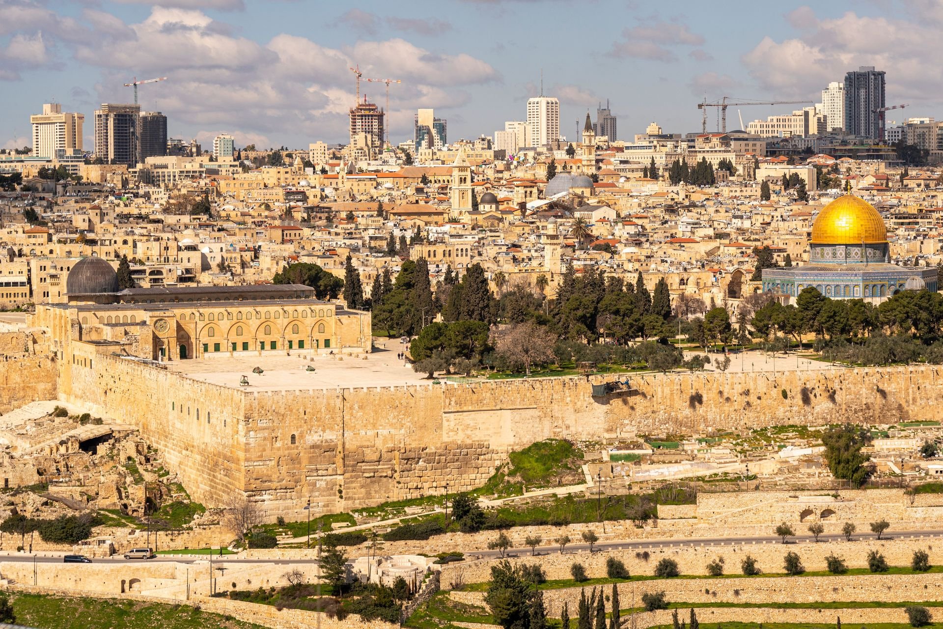
Jerusalem is inscribed on the World Heritage List under a mechanism unique in UNESCO's history: it was nominated not by a state but by Jordan, in 1981, following a request from the Arab states. Israel — which has administered East Jerusalem since 1967 — is not the nominating authority. The site is listed on the "in danger" list, where it has remained continuously since 1982, reflecting both the physical challenges of managing a densely inhabited historic urban area and the unresolved political situation.
The Old City, surrounded by Ottoman walls completed in 1541, covers roughly one square kilometer and is divided into four quarters — Jewish, Muslim, Christian, and Armenian — each organized around its own religious and civic institutions. Within that single square kilometer stand the Western Wall, the holiest site in Judaism where prayer is permitted; the Church of the Holy Sepulchre, built over the site traditionally identified as the location of the crucifixion and burial of Jesus; and the Dome of the Rock and Al-Aqsa Mosque, which together constitute the Haram al-Sharif (Temple Mount), the third holiest site in Islam.
The density of religious significance in such a small area has produced a management system of extraordinary complexity. The Church of the Holy Sepulchre, for example, is shared among six Christian denominations — the Greek Orthodox, Roman Catholic, Armenian, Coptic, Ethiopian, and Syrian Orthodox churches — under an arrangement called the Status Quo, established under Ottoman rule and maintained ever since. The key to the church's main entrance is held by a Muslim family, the Joudeh family, who have been responsible for it since the 12th century; a second Muslim family, the Nuseibeh family, are the doorkeepers.
Construction activity, archaeological excavation, and changes to access arrangements around the Haram al-Sharif have been sources of intense political conflict. UNESCO resolutions on Jerusalem have been contested by member states, and the site's designation reflects the ongoing difficulty of applying heritage frameworks to places that are simultaneously religious, political, and deeply contested.
Credit: José Andrés Pacheco Cortes / Pexels
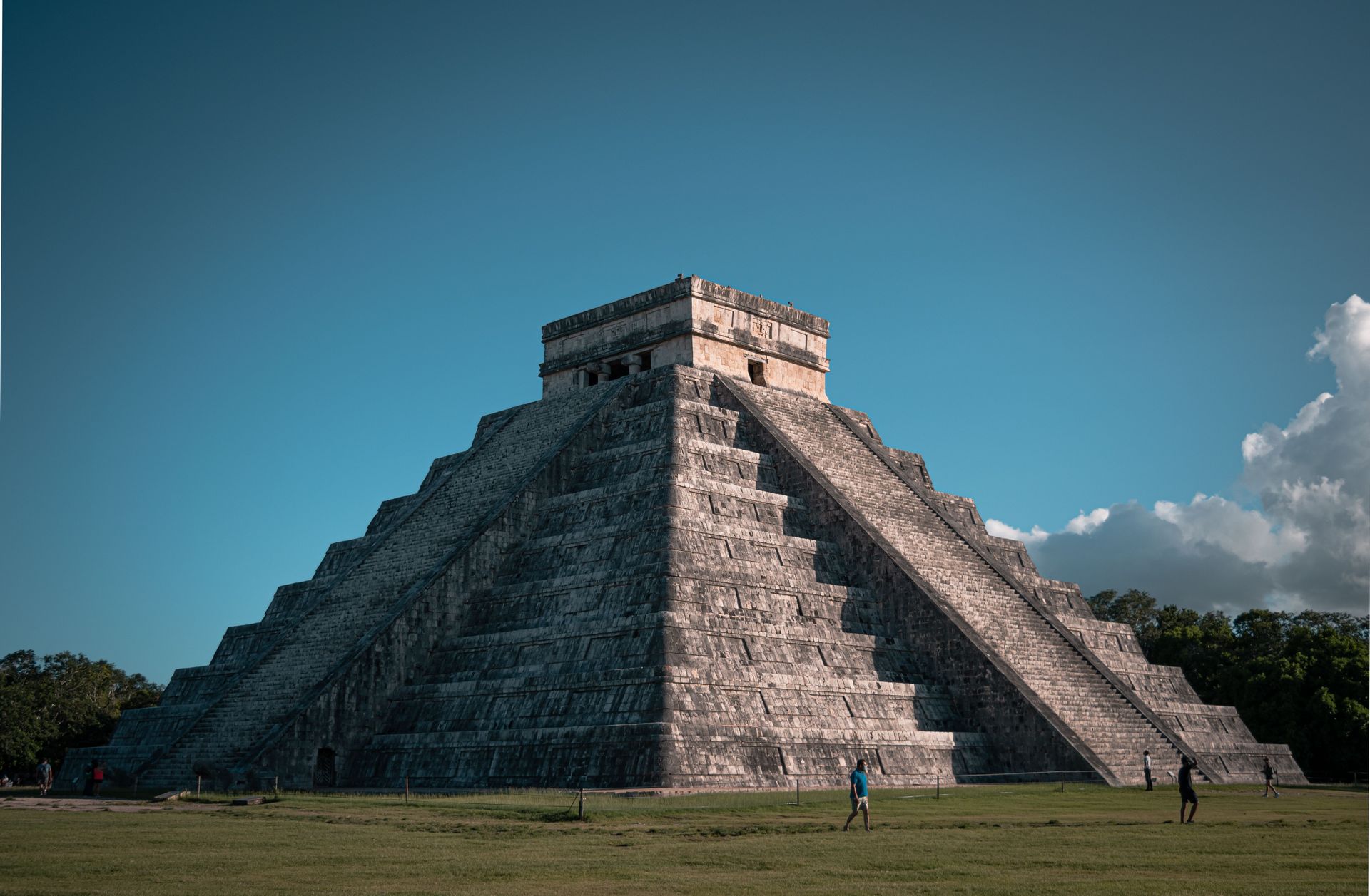
Chichén Itzá was one of the largest and most powerful cities of the Maya civilization, and it dominated the northern Yucatán Peninsula from roughly the seventh through the 13th centuries CE. It is a complex site in the literal sense: different zones of the city show different architectural traditions, reflecting either distinct periods of construction or the presence of different cultural groups — the relationship between the Maya and the Toltec, whose influence appears strongly in the later architectural phases, remains debated among archaeologists.
El Castillo, also known as the Temple of Kukulcán, is the dominant structure: a step pyramid with four staircases of 91 steps each, plus the top platform, totaling 365 steps — one for each day of the solar year. During the spring and autumn equinoxes, the shadow cast by the pyramid's terraces creates the appearance of a serpent descending the northern staircase, with the carved stone serpent heads at the base serving as the body's terminus. This alignment with the solar calendar is deliberately engineered into the structure's geometry.
The Great Ball Court at Chichén Itzá is the largest ball court in Mesoamerica, measuring roughly 168 meters long and 70 meters wide. The rules of the ballgame played there are not fully understood, though the stone rings set high on the court walls were clearly goals of some kind. The carvings on the court's walls show scenes of decapitation, which has been interpreted as evidence of ritual sacrifice connected to the game, though whether victims were the losers or winners of the game is still debated.
The Sacred Cenote — a natural sinkhole roughly 60 meters in diameter and 27 meters deep — was used as a site of ritual offering. Dredging operations in the early 20th century recovered gold, jade, rubber, and human skeletal remains from its depths. Modern archaeological analysis of the skeletal material has provided information about the demographics of those sacrificed.
The site receives more than three million visitors per year, making it the second most visited archaeological site in Mexico after Teotihuacan.
Credit: Julia Taubitz / Unsplash
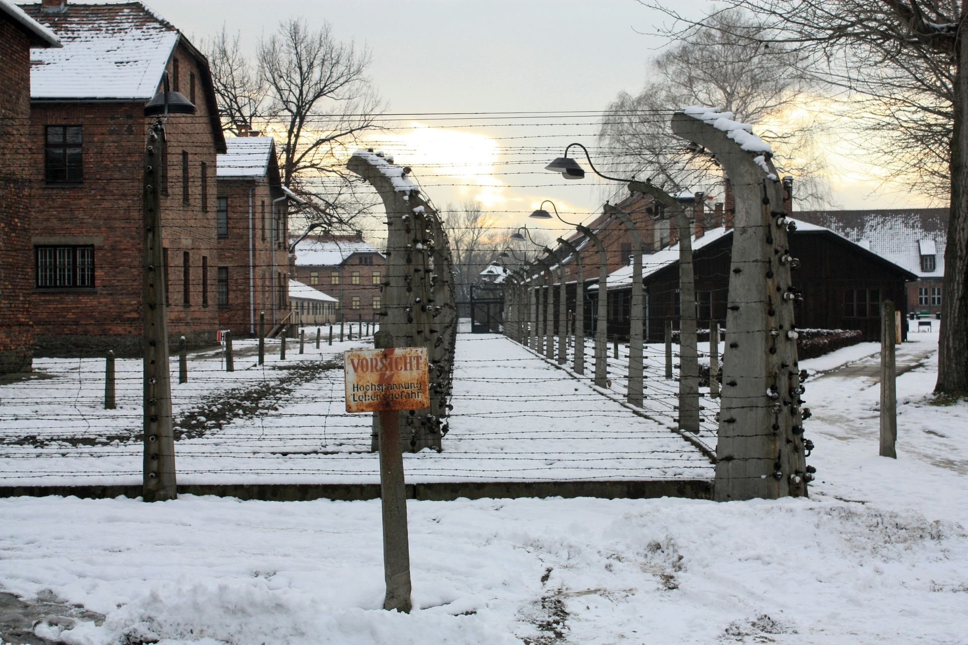
Auschwitz Birkenau — the complex of concentration and extermination camps operated by Nazi Germany in occupied Poland — was inscribed on the World Heritage List in 1979, an early and deliberate statement that the list would include sites of atrocity as well as achievement. The full name of the inscription is "Auschwitz Birkenau German Nazi Concentration and Extermination Camp (1940–1945)," with the nationality of the perpetrators explicitly named in the designation.
The site comprises two main areas: the original Auschwitz I camp, opened in May 1940 in converted Polish army barracks, and the much larger Birkenau (Auschwitz II) camp, built roughly three kilometers away beginning in 1941. At its operational peak, Birkenau covered 175 hectares and held more than 100,000 prisoners. The total number of people killed at the Auschwitz complex — primarily Jews from across occupied Europe, along with Poles, Roma, Soviet prisoners of war, and others — is estimated at between 1.1 and 1.5 million.
The physical remains of the site are explicit in what they document. The ruins of the four crematoria at Birkenau, destroyed by the SS in the final weeks before liberation as Soviet forces approached, are preserved in place. The barracks at Auschwitz I — repurposed to house exhibitions — contain, among other things, several tons of human hair recovered from prisoners, which the Germans were using for industrial purposes. The scale of material evidence is such that the site functions less as a memorial and more as a document.
The challenge of maintaining Auschwitz Birkenau as a site of historical testimony rather than allowing it to become either a spectacle or to deteriorate into illegibility is ongoing. The Auschwitz-Birkenau Memorial and Museum manages access and interpretation. In recent years, concerns about social media behavior at the site — photography for personal display purposes, inappropriate poses — have prompted the museum to develop visitor guidelines specifically addressing conduct.
Approximately two million people visit the site annually. The question of how to honor the memory of victims while enabling education and historical understanding for successive generations is not one the inscription resolves; it only names the site as something humanity must continue to reckon with.
Credit: Maitheli Maitra / Unsplash
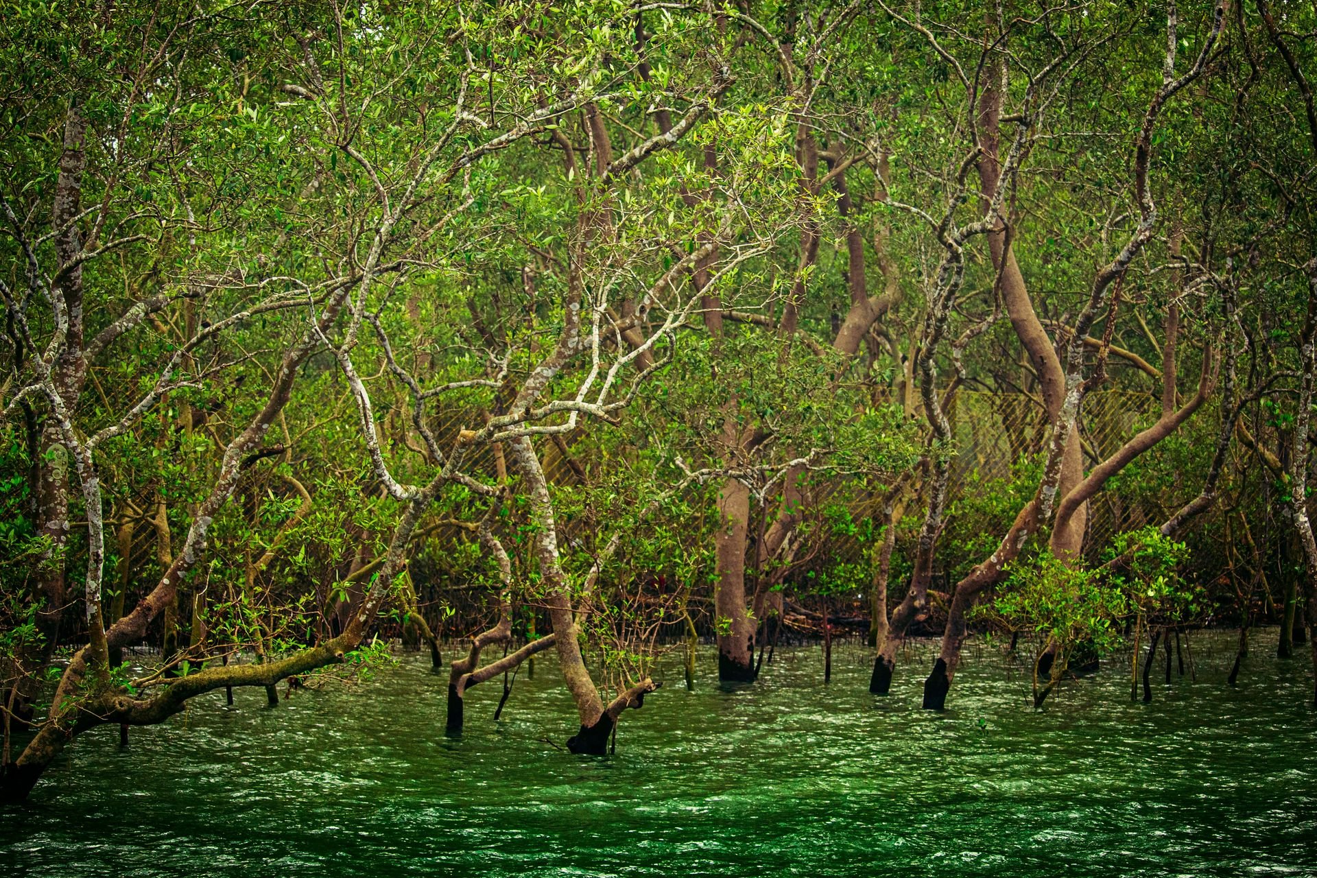
The Sundarbans is the largest mangrove forest on Earth, covering roughly 10,000 square kilometers across the delta of the Ganges, Brahmaputra, and Meghna rivers at the Bay of Bengal. The forest straddles the border between India and Bangladesh: the Indian portion, covering roughly 2,585 square kilometers, was inscribed as a UNESCO World Heritage Site in 1987. The Bangladeshi portion was inscribed separately, also in 1987.
The Sundarbans is defined by its tidal nature. The forest is interlaced with hundreds of waterways, canals, and tributaries that flood with seawater at high tide and drain at low tide, creating conditions that most trees cannot tolerate. The mangroves that have adapted to this environment have specialized root systems — pneumatophores (aerial roots) that allow gas exchange when the soil is saturated — and the capacity to tolerate high salinity. The word "sundarban" is generally understood to mean "beautiful forest" in Bengali, likely a reference to the Sundari tree (Heritiera fomes), which dominates much of the canopy.
The Sundarbans is the primary remaining habitat of the Bengal tiger. The population there is estimated at between 100 and 130 individuals in the Indian portion — precise counts are difficult in dense tidal forest. The Sundarbans tigers are notable for their reported behavior of swimming between islands and, in some cases, preying on humans. The villagers living on the periphery of the forest, who enter it for fishing, honey collection, and wood, have historically faced tiger attacks at rates that are unusually high compared to other tiger habitats.
The ecosystem is under severe pressure from climate change. The Sundarbans lies at sea level, and rising ocean water threatens to inundate significant portions of the forest. The freshwater input that the forest depends on — from the great river systems to the north — is declining as upstream dams and irrigation diversion reduce flow. Salinity is increasing in areas that previously received more freshwater, stressing vegetation and reducing the food available for the ecosystem.
Credit: Tom Hermans / Pexels
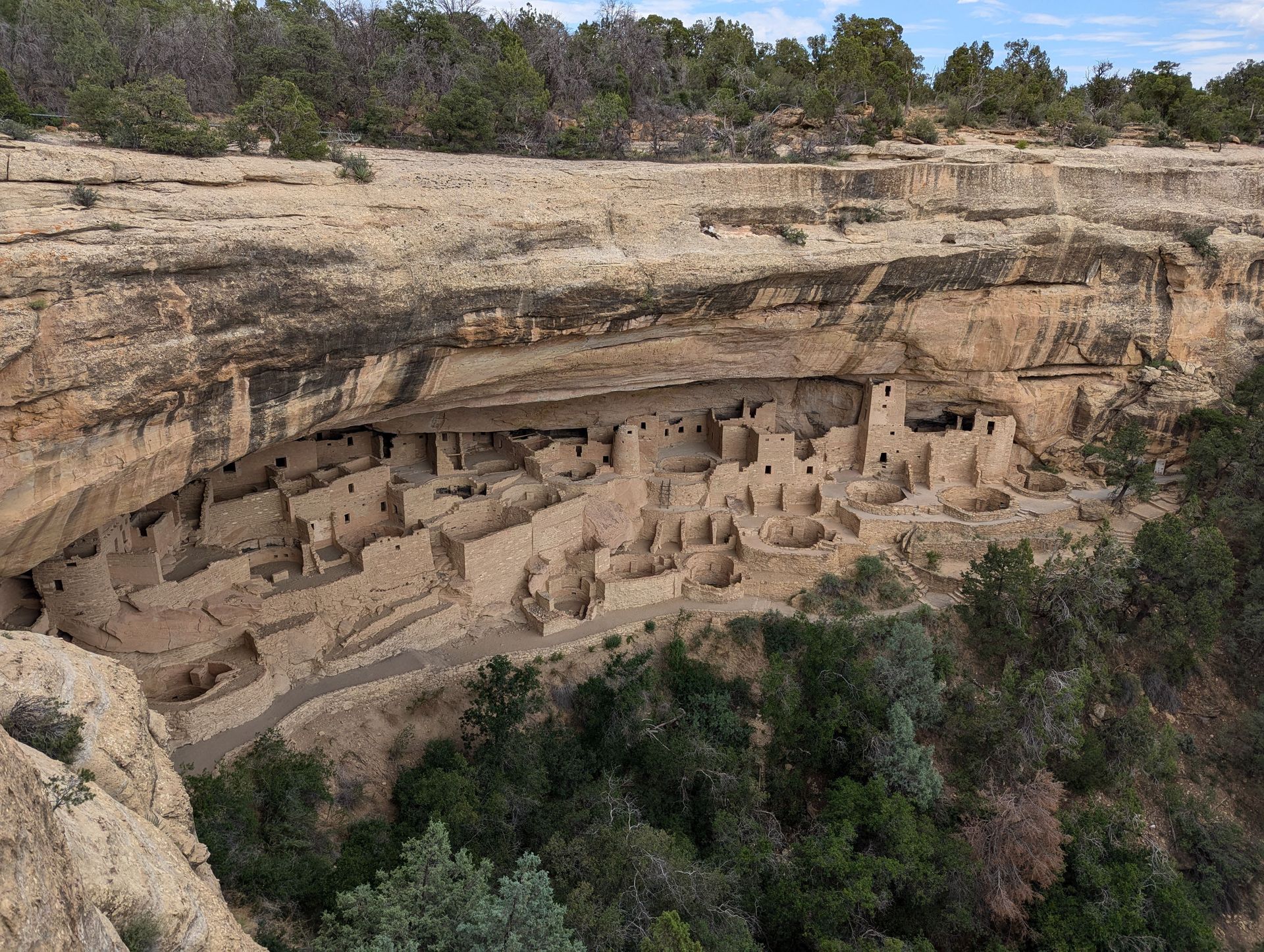
Mesa Verde, in the southwestern corner of Colorado, contains the most extensive and best-preserved assemblage of ancestral Puebloan cliff dwellings in North America. The site was inscribed in 1978, making it one of the first UNESCO sites in the U.S., and it covers approximately 211 square kilometers of mesa and canyon landscape.
The structures that define Mesa Verde were built primarily during the 13th century CE, though the region had been occupied by agricultural communities for at least 700 years before that. The cliff dwellings — carved into natural alcoves in the sandstone cliffs along the canyon walls — were inhabited for less than 100 years before being abandoned around 1300 CE. The reason for the abandonment is not fully understood but likely involved a combination of prolonged drought, environmental degradation from centuries of intensive land use, and social pressures.
Cliff Palace, the largest cliff dwelling in North America, contains approximately 150 rooms and 23 kivas (circular ceremonial structures) and could have housed between 100 and 150 people at its peak. The site is not reconstructed — it is largely as found, with stabilization work done to prevent further deterioration. Visitors can tour Cliff Palace by descending into the canyon on guided tours that include climbing a series of wooden ladders to reach the structure.
The architectural achievement of Mesa Verde is significant not just aesthetically but technically. The builders had no metal tools. They quarried sandstone blocks using stone tools, shaped them with water and abrasion, and mortared them with a mud mixture. The structures include multi-story towers, storage rooms, living quarters, and ceremonial spaces organized in arrangements that suggest sophisticated social organization.
The Ute Mountain Ute and Pueblo peoples who are the cultural descendants of the Mesa Verde inhabitants maintain connections to the site and are involved in its interpretation and management. The site's interpretation has shifted over the decades toward including Indigenous perspectives more explicitly.
Credit: Mehmet Turgut Kirkgoz / Pexels
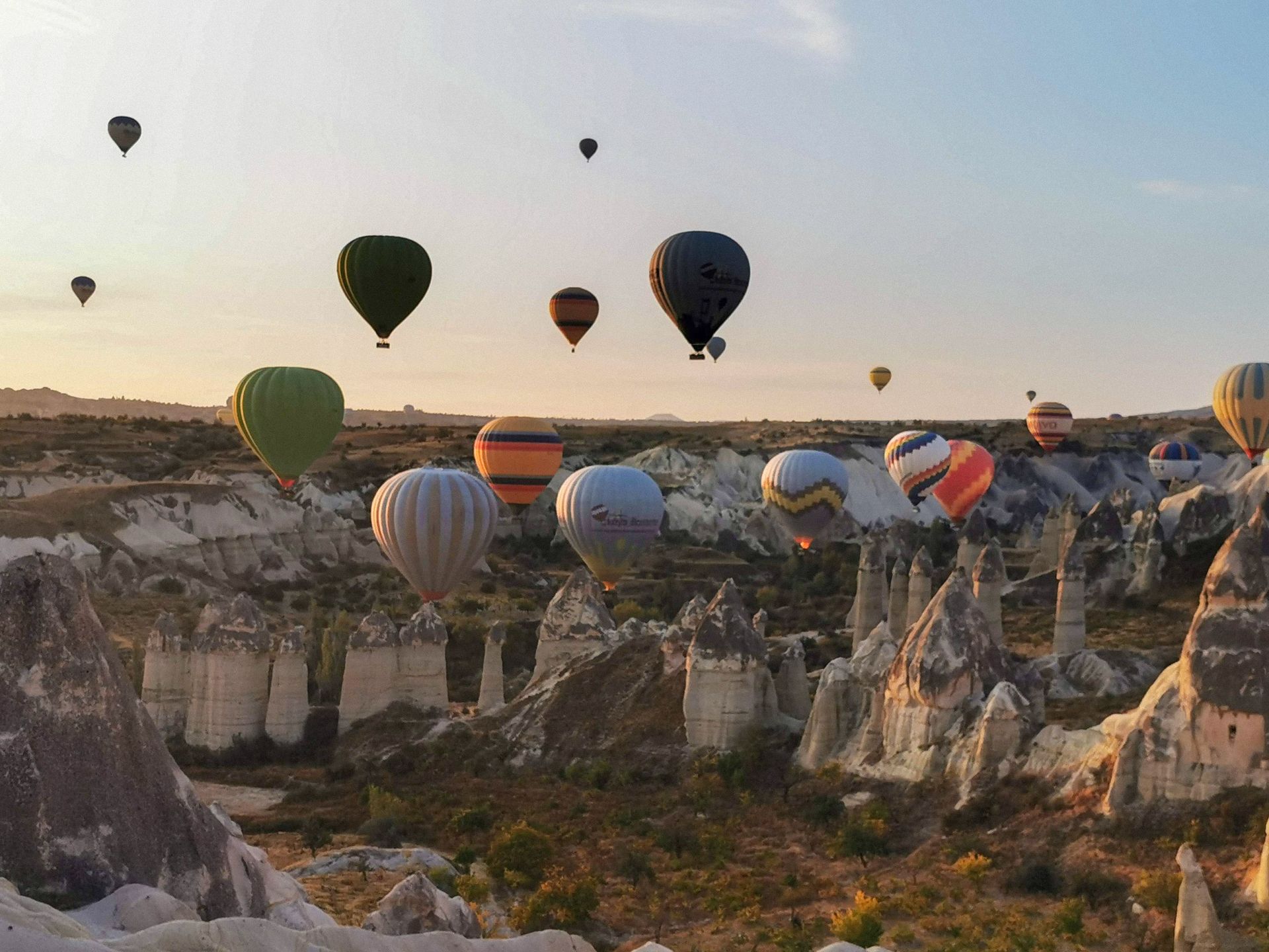
Cappadocia is a region of central Turkey where millions of years of volcanic eruption, followed by slow erosion by wind and water, produced a landscape of conical rock formations — locally called "fairy chimneys" — carved valleys, and natural cave systems. This geological peculiarity allowed human communities over many centuries to carve dwellings, churches, monasteries, and entire underground cities directly into the soft volcanic rock, creating a landscape that looks unlike anywhere else on Earth.
The UNESCO inscription from 1985 covers both the Göreme National Park and the broader Rock Sites of Cappadocia. The region's rock-cut architecture spans from the Bronze Age through the Byzantine period into the Ottoman era. The most significant concentration of rock-cut Byzantine art is in the valley of Göreme, where roughly 30 rock-cut churches preserve frescoes dating from the 9th through the 13th centuries. These frescoes include representations of the entire New Testament narrative in a style that shows both Byzantine formalism and regional idiosyncrasies.
The underground cities of Cappadocia are a separate phenomenon. Derinkuyu, the deepest excavated, extends to roughly 85 meters below ground and was capable of sheltering tens of thousands of people with their livestock, along with food storage, wine presses, oil presses, meeting halls, and ventilation shafts. These cities were used primarily as refuges during periods of military threat, including the Arab raids of the 7th and 8th centuries.
The hot air balloon industry that now defines the Cappadocia visitor experience is a 20th-century addition to this ancient landscape. The flights, most popular at dawn over the fairy chimney formations, have become one of the most photographed tourism experiences in Turkey. The region receives millions of visitors per year, and balloon regulation has been a recurring challenge — the Turkish government has tightened licensing requirements following accidents.
Credit: Hoi Wai / Pexels
The Hiroshima Peace Memorial (Genbaku Dome) was inscribed in 1996 over the objections of Japan's two closest allies: the United States, which voted against the inscription, and China, which abstained. The U.S. objection was based on concerns about historical context — the view that the site could be used to promote a one-sided narrative of the bombing without reference to the broader context of the Pacific War and Japanese aggression that preceded it. The inscription was adopted regardless, reflecting the views of the majority of UNESCO member states.
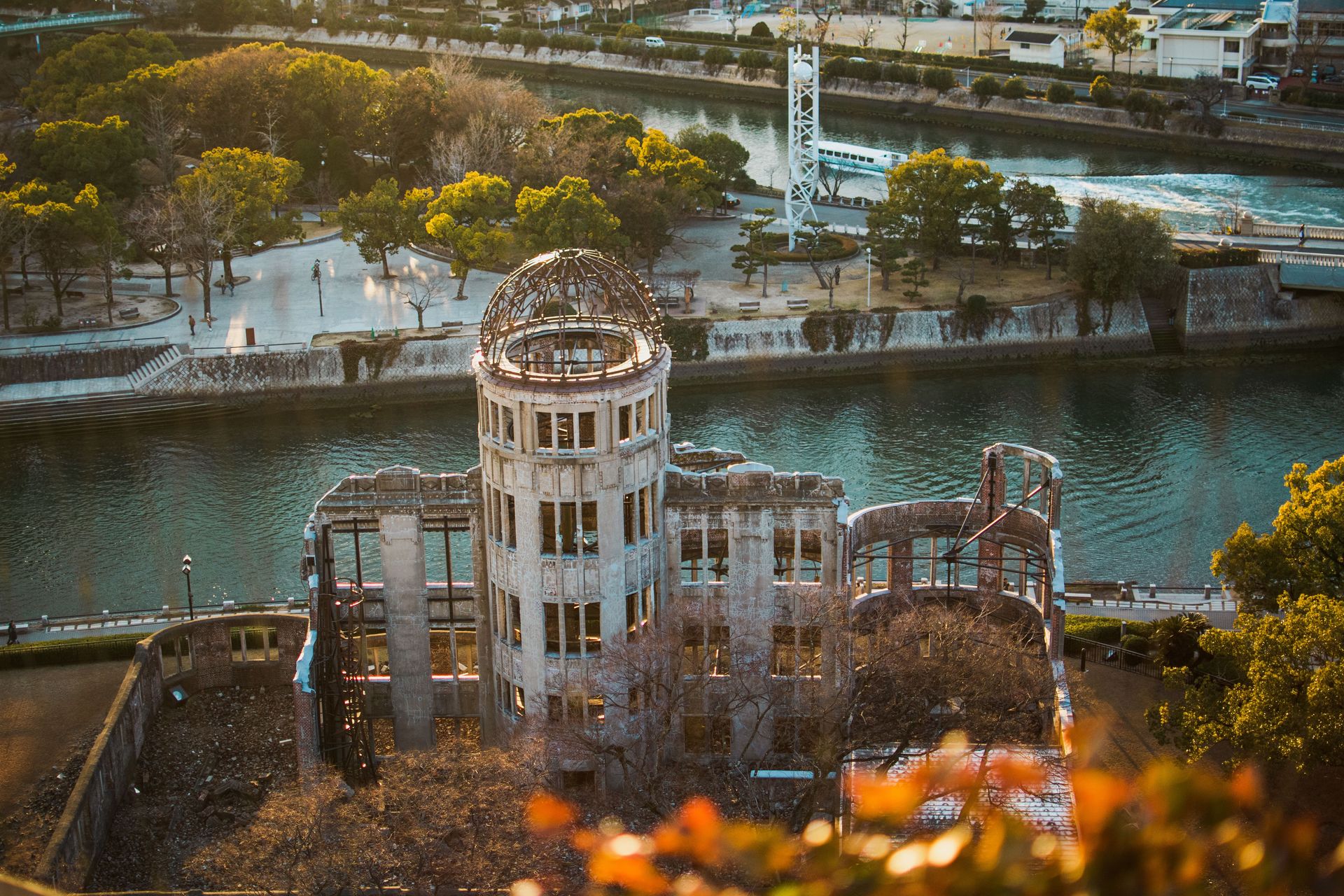
The building that stands — or rather, the ruin that stands — is the Industrial Promotion Hall, designed by Czech architect Jan Letzel and completed in 1915. When the atomic bomb was dropped on Hiroshima on August 6, 1945, the building was nearly directly below the detonation point, roughly 160 meters from the hypocenter. The near-vertical angle of the explosion meant that the downward force passed almost straight through the dome rather than the lateral force that destroyed most of the surrounding city. The skeletal dome frame and the outer walls survived while everything within the building was destroyed and 70,000 to 80,000 people were killed almost instantly.
The building was left as it was — or rather, as it was after the explosion — as a deliberate act of preservation. Annual engineering assessments monitor the stability of the remaining structure, which requires ongoing work to prevent further deterioration. The ruin stands within Hiroshima Peace Memorial Park, established on land that had been a dense commercial district before the bombing.
The Dome is a monument not to a battle or a victory but to a specific moment in which technology crossed a threshold from which there was no return. Nuclear weapons had been used in warfare for the first and, so far, only time. The UNESCO inscription recognized the site as representing, in universal terms, the hope for peace and the elimination of nuclear weapons.
Credit: Stijn Dijkstra / Pexels
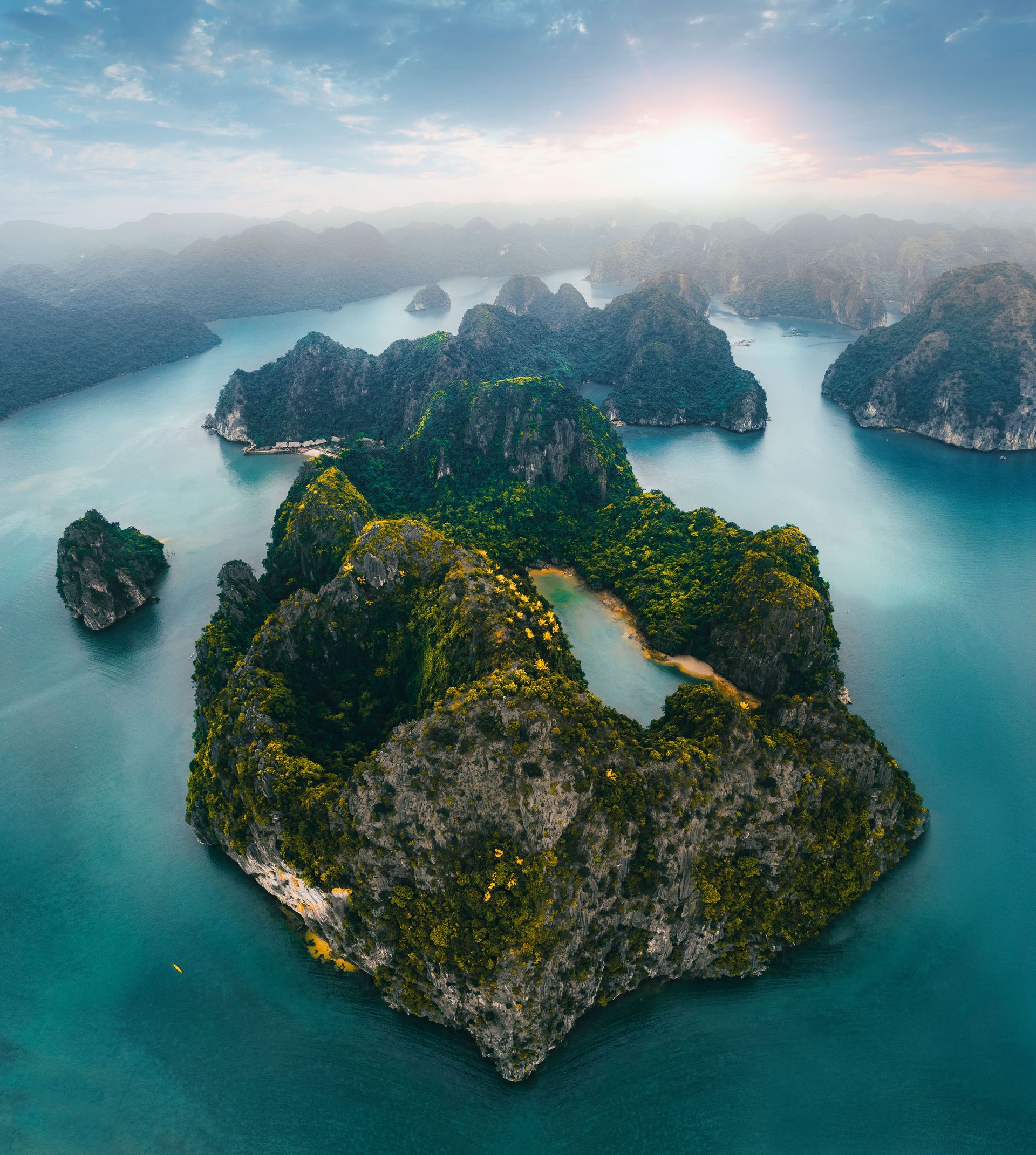
Ha Long Bay, in northeastern Vietnam's Quảng Ninh province, is a seascape of approximately 1,600 limestone islands and islets rising from the Gulf of Tonkin. The formation was created over hundreds of millions of years by the dissolution of limestone by rainwater and sea water, producing a karst landscape of towers, caves, and enclosed lagoons. The UNESCO inscription from 1994 recognized the aesthetic and geological significance of the bay; a 2000 extension added recognition for biological diversity.
The limestone towers, which rise to heights of up to 100 meters, create an environment of unusual visual drama — vertical walls of rock dropping straight into calm water, with fishing villages and small beaches occupying narrow shores within the islands' natural coves. The scale of the bay — covering roughly 1,553 square kilometers — means that despite high visitor numbers, it is possible to reach sections of the bay that are relatively uncrowded, particularly in the Lan Ha Bay area to the south.
The caves within the limestone towers are among the largest in the world. Hang Sơn Đoòng, in the nearby Phong Nha-Kẻ Bàng National Park (itself a UNESCO site), is the world's largest known cave by volume. The caves in Ha Long Bay itself, while smaller, are significant: Hang Đầu Gỗ contains chambers large enough to have served as a Vietnamese weapons depot during the 13th-century resistance against Mongol invasion.
Tourism pressure on Ha Long Bay has been severe. Hundreds of cruise boats operate in the bay, and the disposal of waste from these operations directly into the water has been a documented problem. The Vietnamese government has introduced regulation of boat operations and numbers, suspended new licenses for cruise operators, and invested in waste management infrastructure, though enforcement has been inconsistent.
The bay is also under pressure from coal mining operations in adjacent areas of Quảng Ninh province. Air quality in the region, and the deposition of particulate matter on the limestone surfaces, has been identified as a concern by conservation specialists.
Credit: Canva Images
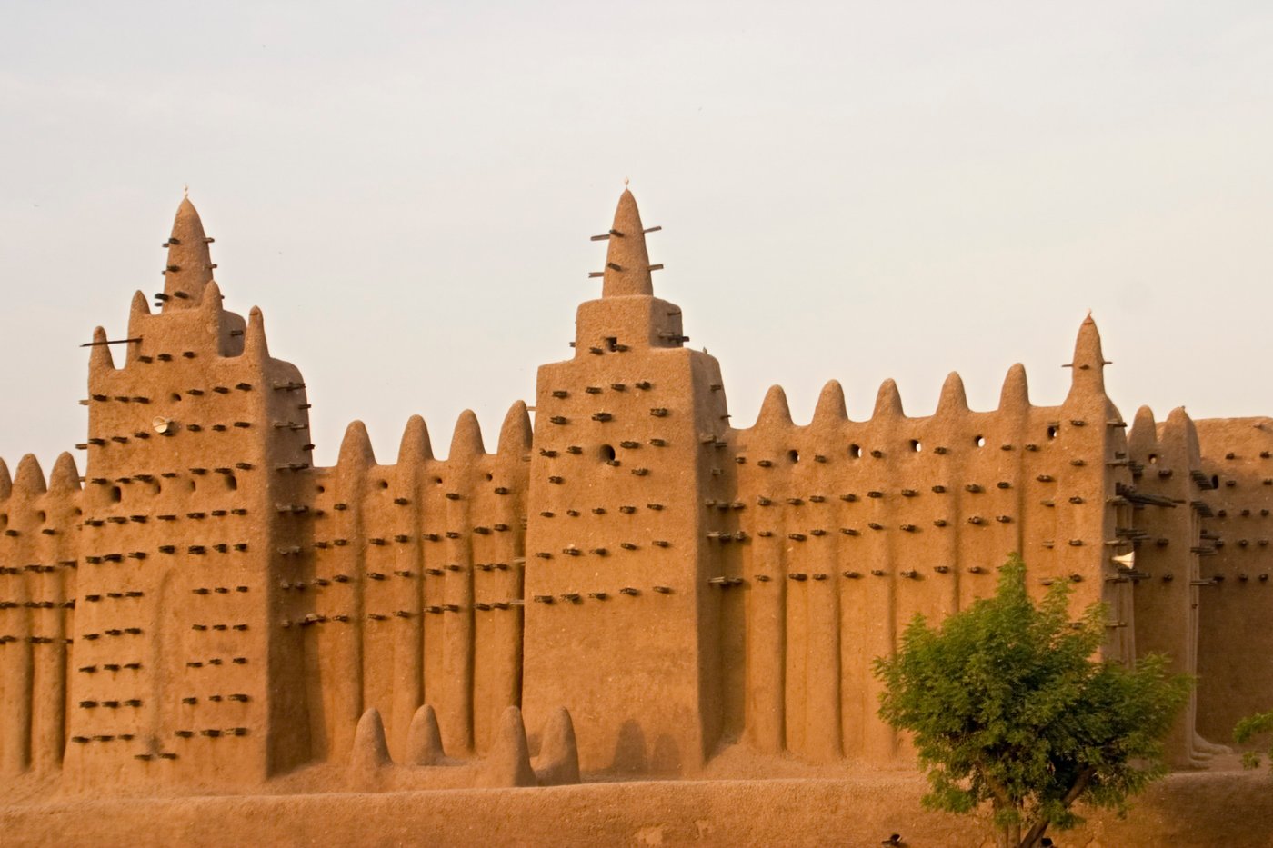
Timbuktu sits at the southern edge of the Sahara in what is now northern Mali, and it reached its greatest significance between the 14th and 17th centuries as a center of Islamic scholarship, trade, and culture. At its height, the city was home to three major mosques and a university at the Sankore mosque that drew students and scholars from across the Islamic world. The library holdings of Timbuktu — hundreds of thousands of manuscripts covering theology, mathematics, astronomy, medicine, and history — represent one of the great accumulations of medieval African knowledge.
The three great mosques — Djinguereber, Sankore, and Sidi Yahia — form the core of the UNESCO inscription, along with 16 cemeteries and mausolea. They were built in the Sudano-Sahelian architectural style, using banco (a mixture of clay, water, and organic material) as the primary construction material. This technique produces buildings of earthen color that blend with the surrounding desert landscape, with wooden beams protruding from the walls — the beams serve as permanent scaffolding, since banco requires annual repair and replastering after the rainy season.
The site has been on the "in danger" list since 2012, when armed extremist groups affiliated with al-Qaeda took control of northern Mali. During the occupation, which lasted several months before French military intervention, occupying forces destroyed 14 of the 16 mausolea, which they considered idolatrous under their interpretation of Islamic law. They also removed library manuscripts from the Ahmed Baba Institute — an institution dedicated to the preservation and digitization of the manuscripts — before its staff had evacuated many of the most significant items.
The mausolea have since been rebuilt using traditional materials and techniques, with local artisans playing a central role in restoration. The rebuilding project was notable for being the first time the International Criminal Court prosecuted the destruction of cultural heritage as a war crime. Ahmad al-Faqi al-Mahdi pleaded guilty in 2016 and was sentenced to nine years in prison.
Credit: Palu Malerba / Pexels
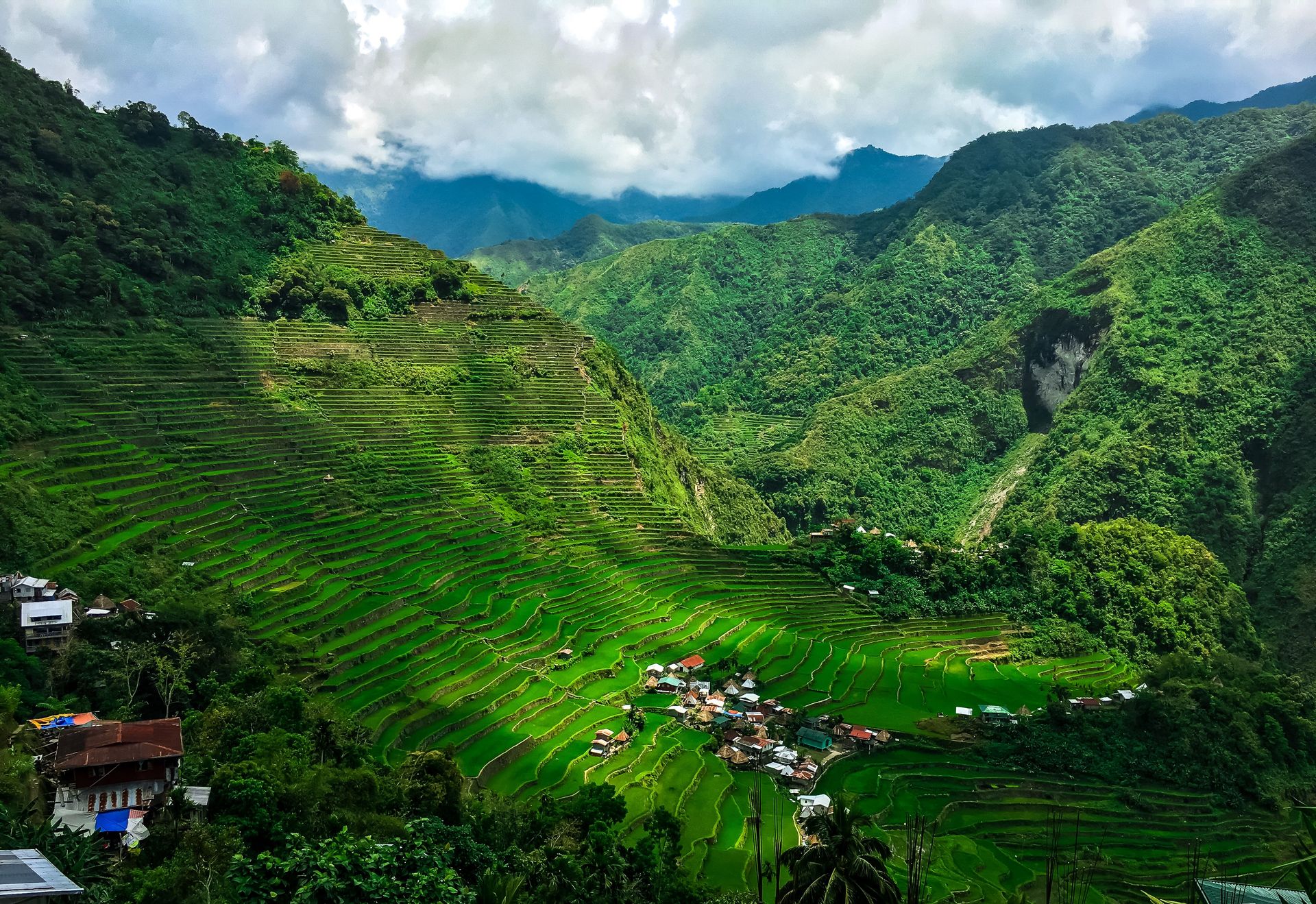
The rice terraces of the Cordillera mountains in northern Luzon are not a single site but a living agricultural landscape carved across five clusters in the Ifugao province — Batad, Bangaan, Hungduan, Kiangan, and the Nagacadan terraces in Mayoyao. UNESCO inscribed them in 1995, recognizing both their engineering significance and their status as a continuously maintained cultural landscape. The Ifugao people have farmed these slopes for approximately 2,000 years, and the terraces remain in active use today.
The scale of the engineering is difficult to grasp from the ground. The terraces step down mountainsides at gradients that would make flat agriculture impossible, retaining narrow strips of level soil through stone and mud walls — some reaching heights of five meters — that follow the natural contours of the terrain. If the walls of the Ifugao terraces were laid end to end, estimates place the total length at roughly 20,000 kilometers. The system was built and is maintained entirely without machinery, using hand tools and collective labor practices that have been passed down across generations.
What makes the terraces function is not just the walls but the water system embedded within them. A network of channels, wooden pipes, and strategically placed dikes draws water from mountain forests above the terraces and distributes it across the paddies in a sequence timed to the growing cycle. The forest cover at the top of the mountains is deliberately maintained by Ifugao communities because it regulates water flow — clearing it would destroy the hydrological balance that the entire agricultural system depends on.
The Ifugao knowledge system governing terrace maintenance, water distribution, and rice cultivation is codified not in written documents but in oral tradition, ritual practice, and the muyong — a privately owned woodlot above each family's terraces that provides timber, water regulation, and forest products. The muyong system is a form of community-based resource management that has sustained the landscape for two millennia.
The site was placed on UNESCO's "in danger" list in 2001 due to declining agricultural productivity, the migration of younger Ifugao generations to urban centers, and the deterioration of terraces left unmaintained as the farming population aged. It was removed from the danger list in 2012 after the Philippine government and local communities demonstrated measurable progress in terrace restoration and the revitalization of traditional farming practices.
The primary ongoing threat is generational. Maintaining the terraces requires intensive year-round labor — clearing channels, repairing walls after heavy rain, managing the muyong, and coordinating water distribution with neighboring families. As younger Ifugao find employment in cities, the number of people with both the knowledge and the willingness to do this work is declining. The terraces that visitors photograph from the viewpoints above Batad are maintained by a community that is actively working to keep a 2,000-year-old system from going silent.
Credit: Canva Images
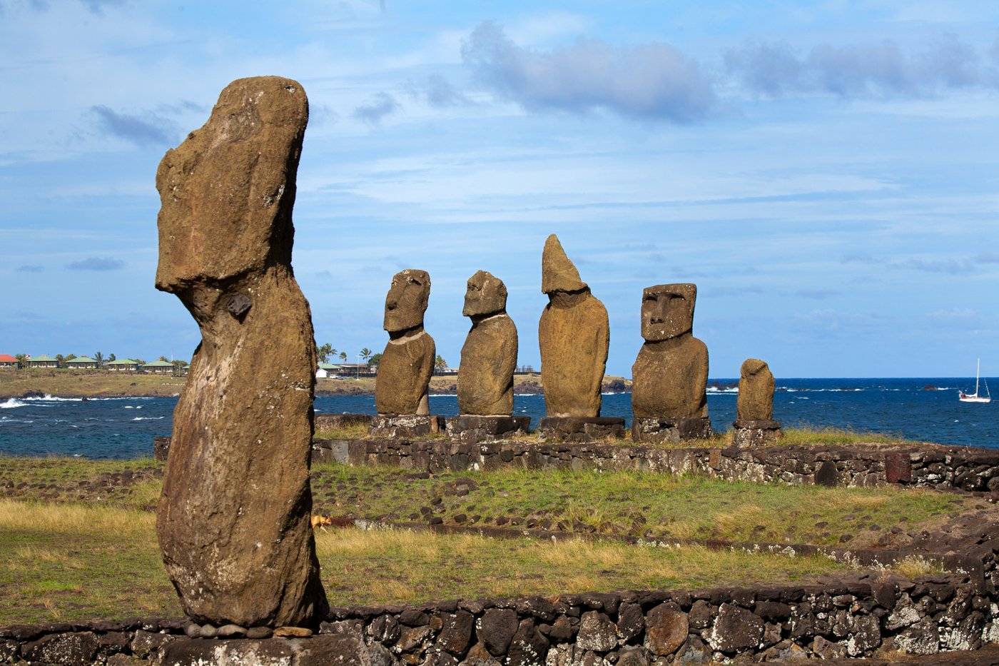
Easter Island (Rapa Nui in the indigenous Polynesian language) sits in the southeastern Pacific Ocean roughly 3,700 kilometers west of Chile's coast and 2,000 kilometers from the nearest inhabited island. It is one of the most remote permanently inhabited places on Earth, and the civilization that developed there produced the moai — the massive carved stone heads (and bodies, most of which remain buried) — that make Rapa Nui one of the most recognizable archaeological landscapes anywhere.
Approximately 900 moai were carved from the volcanic tuff of Rano Raraku, a volcanic crater that served as the principal quarry. The statues range in height from roughly two meters to 10 meters, with some unfinished examples in the quarry that would have reached 20 meters. They were transported across the island and erected on stone platforms called ahu, typically facing inland — looking back over the communities they were meant to protect rather than toward the sea.
The method of moai transport has been studied intensively. The conventional image of the statues being dragged horizontally on wooden sledges has been questioned by research suggesting they were moved upright, "walked" using ropes attached to their sides in a controlled rocking motion. Experimental archaeology has demonstrated the feasibility of this method, and oral traditions on the island support the idea of the moai being made to "walk."
The civilization that built the moai experienced a dramatic collapse, likely linked to resource depletion — the island was once forested and the trees were cleared over time, removing the resources needed for canoe-building and, potentially, statue transport. European contact beginning in the 18th century brought disease, slave raiding, and sheep farming that further diminished the indigenous population. The Rapa Nui people, who are the cultural descendants of the statue-builders, today constitute a majority on the island.
The moai are facing accelerated erosion from climate change, with increased rainfall and coastal flooding damaging platforms and statue surfaces. Chile's National Monuments Council and the Rapa Nui community are engaged in ongoing stabilization work.
