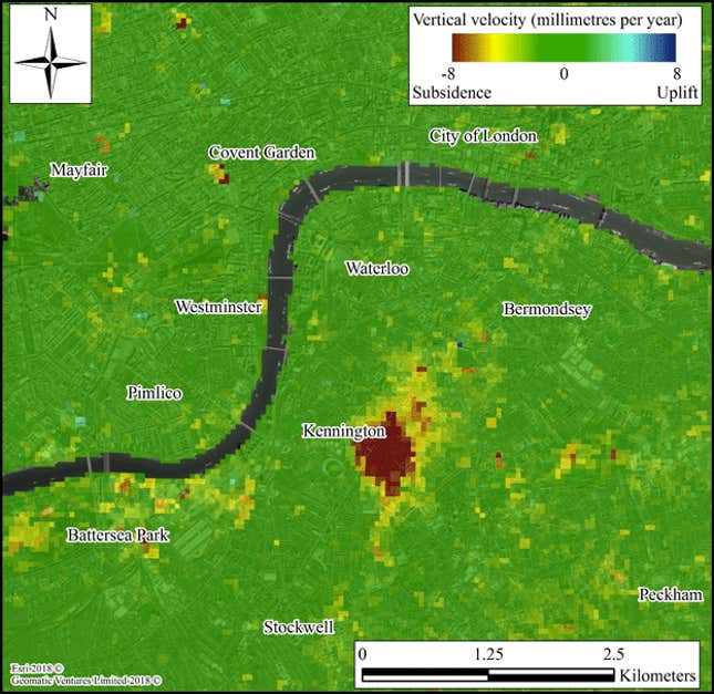
When a European weather satellite took images of a region in south London, it made a surprising discovery: The neighborhood of Kennington has sunk about 1 cm in the past year.

The Sentinel-1 weather satellite is armed with radar that can detect tiny movements up and down of the Earth’s surface. Its job is to help policymakers and industries understand the risks and effects of big infrastructure projects. Geomatic Ventures used Sentinel-1’s data—which was collected between 2015 and 2017—to build a map of the UK, marking out regions of unusual uplift (raising) and subsidence (sinking).
The company says the most likely reason for Kennington’s subsidence is the sinking of shaft—the digging of a vertical tunnel—that was completed in November, as part of an extension of the Northern line on the London Underground. The subsidence occurs as the ground around a freshly dug tunnel settles into its new position.
Though the image looks dramatic, city’s infrastructure is able to deal with a whole area sinking just a little. Where troubles can occur is if some parts go deeper and others don’t. The BBC documented the difficulty of such tunneling work underneath a crowded city during the construction of a new London Underground line called the Elizabeth Line. To tackle the problem, construction companies employ a smart monitoring system that ensures any subsidence is managed carefully.
Other regions in the UK monitored by the Sentinel-1 show larger changes. Some abandoned coal mines in northern England are rebounding, causing an uplift of as much as 1 cm per year, since water pumps were shut in the 1980s and groundwater levels continue to rise. In other places, coal mines are still collapsing and causing subsidence of about the same magnitude as uplift in other places. These movements are important to monitor because parts of the UK’s most expensive rail line—the HS2—will pass on top of old coal mines.
The most surprising find was a place called Willand in the region of Devon that has been rising more than 2 cm per year. “We’ve spoken to the Environment Agency and the British Geological Survey, and right now we can’t explain it,” Andy Sowter, Geomatic’s chief technology officer, told the BBC.
You can expect to hear more surprising news out the ups and downs of the Earth’s surface, as the Sentinel fleet of satellites is set to grow from six currently in orbit to 20, within the next decade.
