Most current-day economists agree that trade leads to growth. A study published by the National Bureau of Economic Research suggests that was also the case during the Iron Age.
Four economists from the Universities of Oxford, Konstanz (Germany), and the London School of Economics, studied communities along the Mediterranean 3,000 years ago. They found those most likely to trade also were likely to be more developed.
There are no import and export statistics from back then. As a proxy, the researchers looked at connectivity: how many markets merchants could reach (at that time, trade distances were dramatically increasing due to sailing ships). To measure growth, the study counted archeological remains, assuming that a more active economy results in more towns and cities.
“We find a pronounced relationship between connectivity and development in our dataset for the Iron Age around 750 BC, when the Phoenicians began to systematically traverse the open sea,” the authors write.
“Our results could be driven by migration or the spread of ideas as well, and when we talk about ‘trade’ we interpret it in this broad sense,” they added. One sign of that spread of people and ideas: thehouse mouse, which traveled as a castaway in Phoenician ships. In a matter of a few centuries, it went from being non-existent west of Greece to settling throughout the central and western Mediterranean, hence the paper’s title: “Of Mice and Merchants: Trade and Growth in the Iron Age.”
World trade
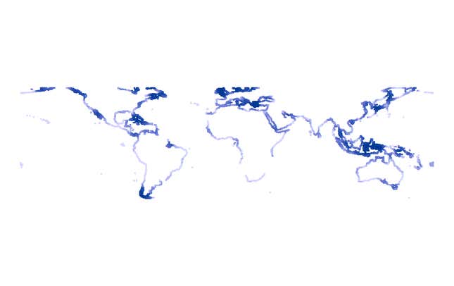
The researchers did the same analysis for other parts of the world, this time using population density as a proxy for growth, and found similar results. Here’s the map of the most connected areas based on their geography, in darker blue. (To measure connectivity, the researchers laid a grid over the coastal areas, and calculated how many other “coast” cells could be reached by traveling up to 500 kilometers— around 310 miles.)

To be sure, conditions have changed dramatically since those days. Today geography does not limit traders in the same way as before thanks to fuel, airplanes, and the internet. But looking at the past is useful “to understand where we are, why trade has shaped human wealth, human geography, and where humans settle for a long time,” said Stephan Maurer, one of the paper’s co-authors.
Some of the dark blue areas in the map remain among the most developed today.
