In 2018, 106 rockets left Earth’s atmosphere carrying over 120 satellites in total. They joined the ranks of the already 1,768 orbiting instruments relaying communications, studying stars, and looking back down at earth. With more satellites comes more frequent views of the Earth, making it simpler than ever to track and report on world events. Sometimes the satellite images break the news itself. We asked experts to tell us what they thought were the most important images to come from outer space this year.
In 2018, 106 rockets left Earth’s atmosphere carrying over 120 satellites in total. They joined the ranks of the already 1,768 orbiting instruments relaying communications, studying stars, and looking back down at earth. With more satellites comes more frequent views of the Earth, making it simpler than ever to track and report on world events. Sometimes the satellite images break the news itself. We asked experts to tell us what they thought were the most important images to come from outer space this year.
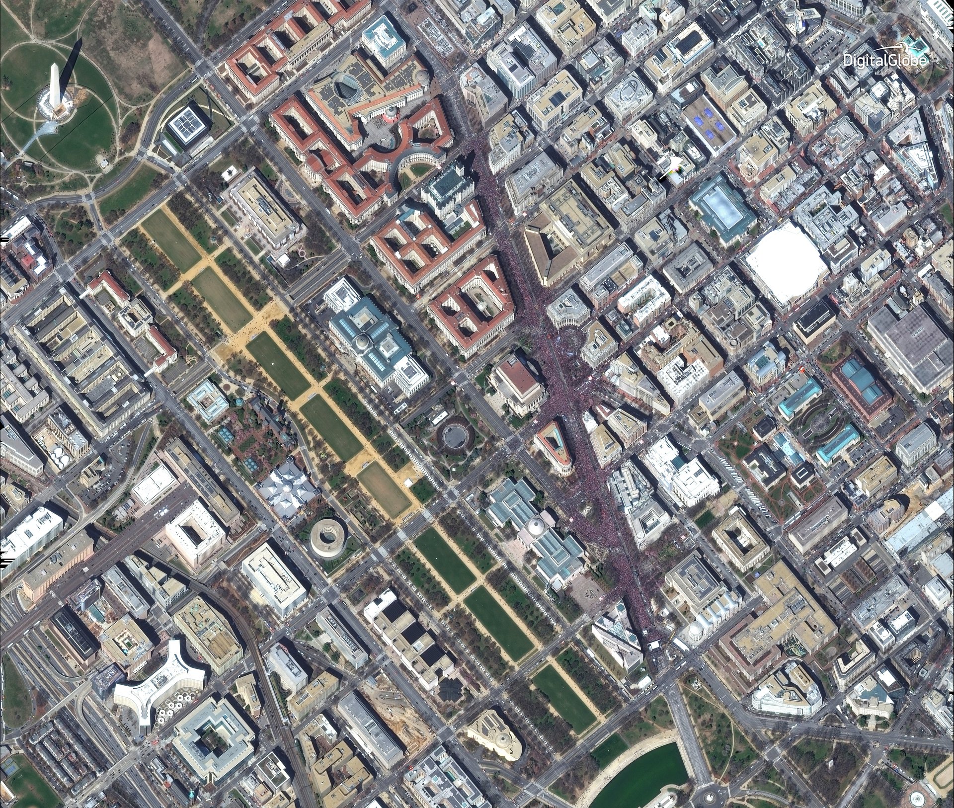
Despite what Hollywood might make you believe, few satellites can discern individual people from space. On occasion, however, satellites can detect large groups of people. While it might not see the crowds at president Trump’s inauguration, because of their sheer numbers and density we can observe the protestors participating in “March for Our Lives.”
Join 500,000+ readers who start their day with Quartz.
By subscribing, you agree to our Terms of Service and Privacy Policy.
“These images were collected by DigitalGlobe’s WorldView-2 satellite, shortly before noon on March 24. The ‘March for Our Lives’ student-led demonstration took place in Washington D.C. … to rally against gun violence following the school shooting at Marjory Stoneman Douglas High School in Parkland, Florida. Thousands of people marched along Pennsylvania Avenue in Washington DC and can be seen in these dramatic satellite images.”
—Stephen Wood, Senior analyst at DigitalGlobe
California experienced its deadliest wildfire in its history, the Camp fire. Ultimately burning over 150,000 acres—engulfing the entire town of Paradise—the fires lasted seventeen days. Satellite imagery provided timely information on a blaze that grew 50% of its size within the first 24 hours.
“The Camp Fire started on November 8th at 6:30am, and Planet captured a first look at the fire at 10:30am the same day. We shared this image with California’s Office of Emergency Services and it helped CalOES document the scale and impact of the fire and request a declaration of a state of emergency, which opened up access to federal resources. The Camp Fire was incredibly devastating and sad, and we were humbled to be able to offer any support.”
—Brittany Zajic, Disaster Response Operations Lead at Planet
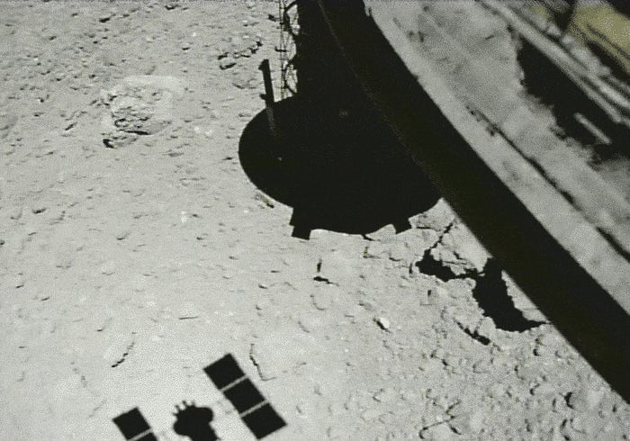
A detour from the Earth for a minute: in September, over 180 million miles away (289 million km), the JAXA asteroid explorer, Hayabusa2 landed on the asteroid Ryugu. The images taken from its onboard camera animates the Japanese spacecraft’s retreat from the rocky surface below.
“[The animation] shows how much work goes into missions like these—years of planning and practice before the grand event. Even 180 million miles away, we are still prepping for the final sample return. This image shows the spacecraft ascending from the surface of Ryugu after running a touchdown test. When you’ve spent years of lives and millions of dollars, you want to make sure you do it right!”
—Dr. Tanya Harrison, Director of Research of ASU’s NewSpace Initiative
During the summer, while the US and North Korean leaders discussed nuclear arms reduction, commercially-owned satellites revealed ICBM transportation at a facility not too far from Pyongyang. The Washington Post reported that spy agencies believe North Korea is continuing its ICBM development.
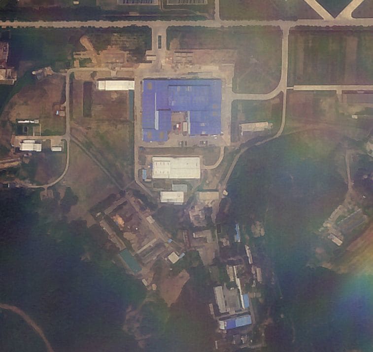
Image: Sanum-dong missile assembly facility, North Korea
“The biggest story in arms control during 2018 was the Singapore Summit. Trump has claimed that Kim Jong Un agreed to abandon his nuclear weapons, while most experts (including yours truly) have pointed that Kim has said nothing of the kind. The image of vehicles arriving at North Korea’s missile production facility in Sanum-dong, taken by Planet… shows that North Korea is continuing to build ICBMs that can threaten the United States.”
—Dr. Jeffrey Lewis, Director of the East Asia Nonproliferation Program at CNS
ESA’s Sentinel-2 satellites offer broad range and frequent imagery of the Earth’s surface. As a government-funded agency, their imagery is free to the public. These wide area photos contributed to reporting on the 2018 heatwave experienced across the northern hemisphere.
Image: United Kingdom
“These images show how weather can have an influence on our daily life. The extremely dry summer had an impact on the people, agriculture, shipping and many other areas. It led to higher gas and wheat prices and demonstrates what climate change could do to the future summer weather in central Europe. It is still weather, which changes from year to year. Even though we know that what we see in the images is only a comparison between 2 years, it is still impressive how different the same region can look.”
—Robert Meisner, Earth Observation communication program officer at ESA
This image shows the manmade structures on an ephemeral tidal island outside of Bangladesh. According to a Reuters report, the Bangladesh government intends to house 100,000 Rohingya refugees here.
“Early in 2018, our partners at Human Rights Watch used Planet data to carefully document the bulldozing of Rohingya villages by the Burmese government in the isolated Maungdaw province of Myanmar. With daily satellite imagery of everywhere on earth, organizations like HRW can track and mitigate human rights violations in remote and dangerous parts of the world from much safer locations.”
—Andrew Zolli, VP of Global Impact at Planet
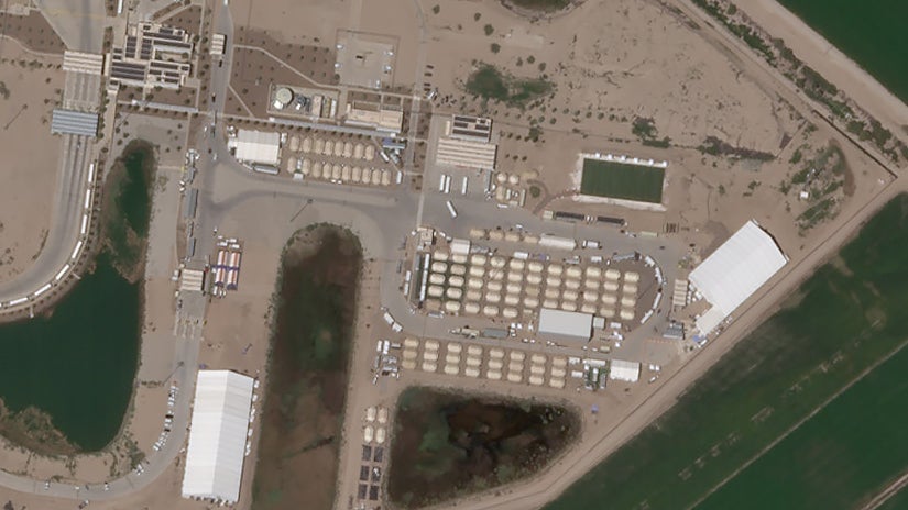
In June, the Washington Post reported the appearance of temporary housing for migrant children seized at the border. At one facility in Tornillo, Texas, the tents only grew in number as the summer turned to fall.
“In mid-June, at the height of the family separations crisis, a tent city for migrant children sprung up in the Chihuahuan Desert in the West Texas town of Tornillo. The “shelter”—as the feds call it—was erected in response to an influx of children being separated from their parents at the border. But 6 months after Trump terminated his family separations policy, the facility continues to hold some 2,700 kids. That’s the result of another Trump initiative: a crackdown on undocumented adults trying to sponsor migrant kids. On Tuesday, a week before Christmas, Trump walked back part of that crackdown—spurring hopes the tent city might soon vanish from the desert.”
—Gus Bova, Reporter at the Texas Observer, covering U.S. immigration
Satellite imagery identified detention centers in the northwest region of Xinjiang, China. The photos corroborated reports that the Chinese government forcibly moved ethnic Uighur Muslims into camps.
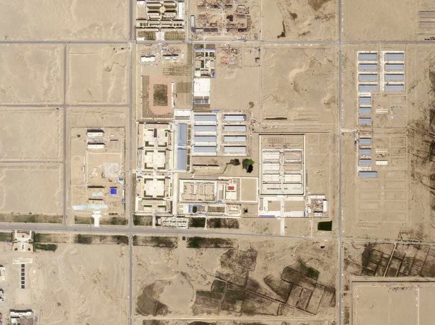
Image: Hotan, China
“The availability of satellite images has been crucial for increasing the impact of reporting on Xinjiang’s political re-education camps. Firstly, they enabled us to verify the existence of these camps, based on specifications contained in other documents, such as government construction and procurement bids. Secondly, satellite images of such facilities create a strong visual impact among the general public, especially when they show construction progress over time. Vast structures emerge out of nowhere. This has helped to visualize the scale of China’s internment drive in Xinjiang.”
—Adrian Zenz, Expert on China’s minority policy.
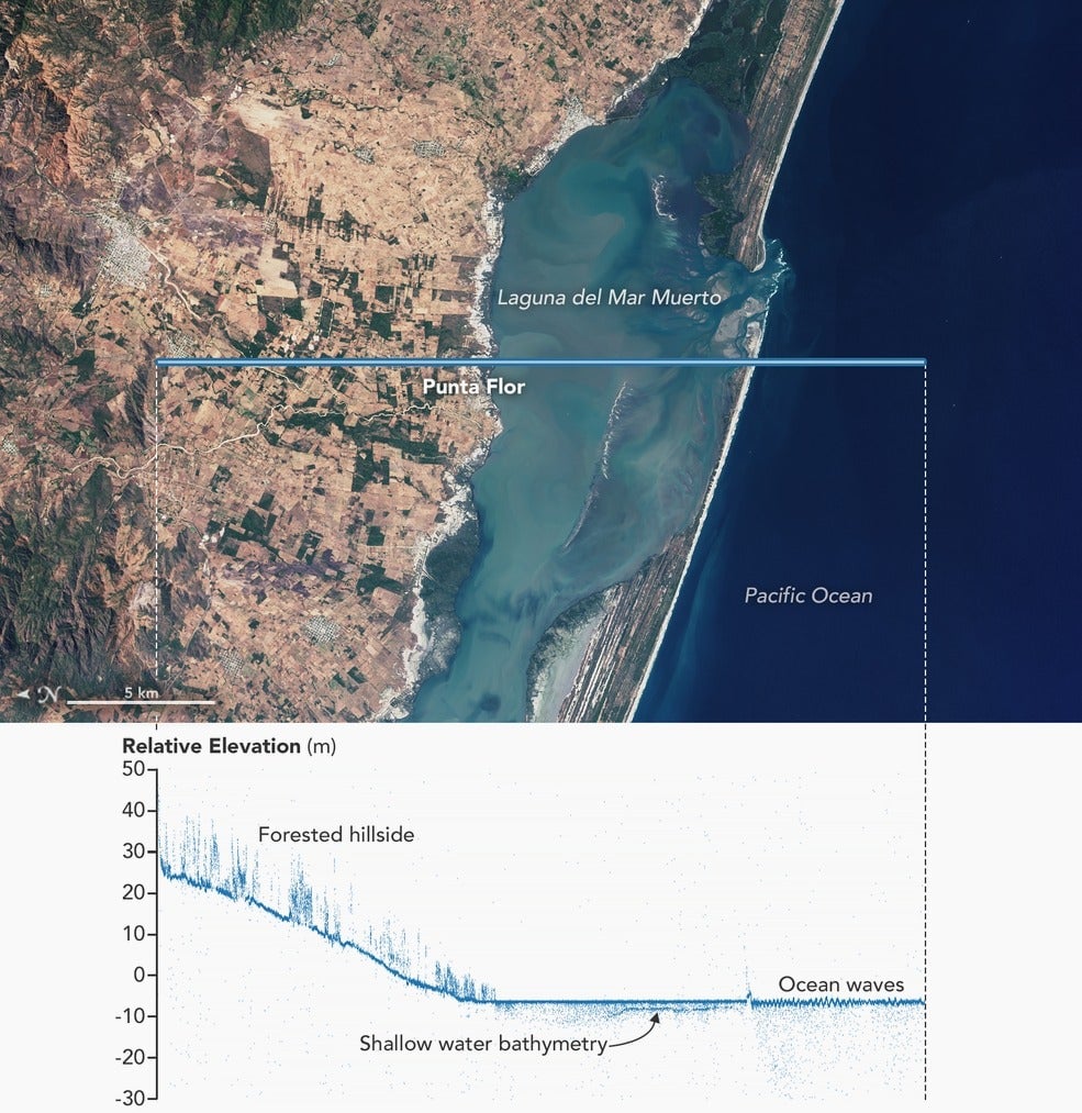
The Ice, Cloud and land Elevation Satellite-2, or ICESat-2 measures within an inch of accuracy the elevation of land, sea, and ice using a single laser to gauge the Earth’s surface. Launched this year, the satellite is “exceeding scientist’s expectations,” with more of its data to be released in 2019, according to NASA.
“IceSat-2 is designed to record fine-grained changes in the planet’s cryosphere – our glaciers and ice caps. By measuring the time of the [laser] light pulses’ returns … we can use this data to see minuscule changes in things like the thickness of arctic sea ice. But IceSat-2’s cross-section maps can also see vegetation, and down into shallow water! Shallows are particularly interesting because they’re poorly mapped, worldwide… Yet for photosynthesis, reef ecosystems, flood control, and other reasons, shallows are particularly important in the environment. So an ice-oriented satellite may end up giving us insights about tropical lagoons.”
—Charlie Loyd, Satellite imagery specialist at Mapbox
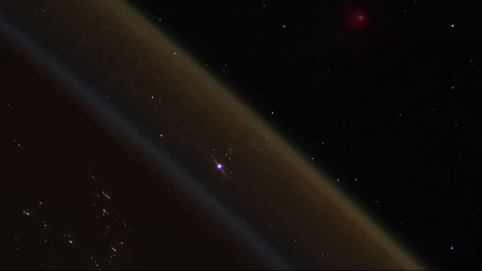
After awhile, fractal suburban developments, the circular patterns of center-pivot irrigated fields, or epic sky scrapers casting shadows on the surrounding sprawl, begins to feel stale. However this year produced a view from above, on par with Voyager 1’s famous dust-like image of earth, which astronomer and physicist Carl Sagan famously called the “pale blue dot.”
In this video shot aboard the ISS, we see a Russian vessel reach escape velocity from Earth’s gravity on a resupply mission to the space station. The sum of humankind’s scientific achievements are seen as red and palish blue spec streaking out from the luminous planet below it. Take a look for yourself, gain some perspective, and have an excellent new year.
Image: Somewhere above Kazakhstan in low Earth orbit